Via the CBC, for all of those looking to include more indigenous content into their lesson plans, when the textbook publishers and the government appointed panels fail us:
A librarian at the Ontario Institute for Studies in Education (OISE) at the University of Toronto has compiled a list of Indigenous education content available.
The resource compilation is a response to the recent cancellation of Truth and Reconciliation curriculum writing sessions that were to build upon Ontario’s curriculum by infusing Indigenous knowledge and pedagogy across all subjects and grades.
Educators and librarians doing it for themselves – we owe it to the next generations to curate a more expansive definition of world literature and history!
The United States: An Open Ended History is a free online history textbook adapted and expanded upon from open sources. Its chapters are designed to address most state standards, splitting the difference between overarching themes, concise summary, and the kinds of vivid, personal details that make history memorable to the average student. Please use and share freely – to supplement or replace what you have at hand.
One – A Not So-Distant Past: Native America (Until 1600)
The Neolithic Revolution – also known as the Agricultural Revolution – was the wide-scale transition of many human societies from a lifestyle of hunting and gathering to one of agriculture and settlement, making an increasingly larger population possible. These settled communities permitted humans to observe and experiment with growing plants. This new knowledge led to the domestication of plants.
The Neolithic Revolution involved far more than the adoption of a limited set of food-producing techniques. During the next millennia it would transform the small and mobile groups of hunter-gatherers that had hitherto dominated human pre-history into sedentary (non-nomadic) societies based in built-up villages and towns. These societies radically modified their natural environment by means of specialized food-crop cultivation, with activities such as irrigation and deforestation which allowed the production of surplus food. Other developments found very widely are the domestication of animals, pottery, polished stone tools, and rectangular houses.
These developments, sometimes called the Neolithic package, provided the basis for centralized administrations and political structures, hierarchical ideologies, writing, cities, specialization and division of labor, more trade, the development of non-portable art and architecture, and property ownership.
ACTIVITY – Join the Neolithic Revolution Advertisement
Create an advertisement urging human beings to settle down and join the Neolithic Revolution. Your ad should be artistic, creative, and appealing, but should also communicate the key changes/benefits that an agriculturally-based lifestyle will bring to those who adopt it – using at least 3/4 of the vocab words found in your textbook.
You must also utilize at least two of the following – the seven most common techniques of persuasion used in advertising:
Testimonial – a story from someone, usually famous, who has used the product
Glittering Generalities – words that cannot really be measured, like “great”
Transfer – using this product will make you “cool” or “attractive”
Plain Folks – a common person who can understand and empathize with a listener’s concerns.
Bandwagon – everybody’s doing it, you’re being left behind
Name Calling – bashing the competition
Card Stacking – shows the product’s best features, tells half truths, omits potential problems.
Aside from our genes, what makes humans different from other animals?
Humans (Homo sapiens) are the only extant members of the subtribe Hominina. Together with chimpanzees, gorillas, and orangutans, they are part of the family Hominidae (the great apes, or hominids). A terrestrial animal, humans are characterized by their erect posture and bipedal locomotion; high manual dexterity and heavy tool use compared to other animals; open-ended and complex language use compared to other animal communications; larger, more complex brains than other animals; and highly advanced and organized societies.
Early hominins—particularly the australopithecines, whose brains and anatomy are in many ways more similar to ancestral non-human apes—are less often referred to as “human” than hominins of the genus Homo.[5] Several of these hominins used fire, occupied much of Eurasia, and gave rise to anatomically modern Homo sapiens in Africa about 315,000[6] years ago. Humans began to exhibit evidence of behavioral modernity around 50,000 years ago, and in several waves of migration, they ventured out of Africa and populated most of the world.
The spread of the large and increasing population of humans has profoundly affected much of the biosphere and millions of species worldwide. Advantages that explain this evolutionary success include a larger brain with a well-developed neocortex, prefrontal cortex and temporal lobes, which enable advanced abstract reasoning, language, problem solving, sociality, and culture through social learning. Humans use tools more frequently and effectively than any other animal; and are the only extant species to build fires, cook food, clothe themselves, and create and use numerous other technologies and arts.
Humans uniquely use such systems of symbolic communication as language and art to express themselves and exchange ideas, and also organize themselves into purposeful groups. Humans create complex social structures composed of many cooperating and competing groups, from families and kinship networks to political states. Social interactions between humans have established an extremely wide variety of values, social norms, and rituals, which together undergird human society. Curiosity and the human desire to understand and influence the environment and to explain and manipulate phenomena (or events) have motivated humanity’s development of science, philosophy, mythology, religion, anthropology, and numerous other fields of knowledge.
Modern reconstruction of what a Neanderthal probably looked like in real life. In a sense, this species of human went extinct about 40,000 years ago – after living side-by-side with Homo Sapiens for tens of thousands of years. In another very real sense, they haven’t gone anywhere – if you have European ancestry, you likely carry Neanderthal DNA.
Though most of human existence has been sustained by hunting and gathering in band societies, increasingly many human societies transitioned to sedentary agriculture approximately some 10,000 years ago, domesticating plants and animals, thus enabling the growth of civilization. These human societies subsequently expanded, establishing various forms of government, religion, and culture around the world, and unifying people within regions to form states and empires. The rapid advancement of scientific and medical understanding in the 19th and 20th centuries permitted the development of fuel-driven technologies and increased lifespans, causing the human population to rise exponentially. The global human population was estimated to be near 7.7 billion in 2019.
ACTIVITY – Interpreting Paleolithic and Neolithic Art
Humans have been producing art works for at least seventy-three thousand years.
Look at the following art, which dates back to the Paleolithic Age – the Old Stone Age, before humans discovered how to farm. For each piece, respond to the following:
Describe what you see with your eyes (figures, colors, size, etc)
Offer an interpretation – What was this artist trying to communicate? What was the purpose of this art?
What can we learn about this artist’s way of life from this art?
What modern artwork or form of expression does this ancient piece remind you of, and why?
A. Grotte de Niaux.
B. Laas Geel.
C. Cueva de las Manos.
D. Venus of Willendorf.
E. Bradshaw Rock.
What art will you leave behind as a testament to your presence on Earth? Create your own piece of “rock art” – though please don’t paint it on the classroom wall – depicting the important things in your life.
More information about each piece can be found here.
Describe the geography of Morocco. How does it compare to the geography of your hometown or country?
What factors have brought foreigners to Morocco over the centuries?
Who was King Hassan II? How did he want to be remembered? How should he be remembered?
Based on the information in this article – as well as further online research – design a two week tour itinerary of Morocco that focuses on historically and culturally significant sites reflecting Morocco’s history. Where will you go? How will you travel between attractions? Where will you stay? What will you eat for each meal? Be sure to explain why each of your stops is significant enough to be included in your itinerary.
Geography
The nation of Morocco is in the northwest corner of Africa, with a coastline along the Atlantic Ocean, reaching past the Strait of Gibraltar into the Mediterranean Sea. It is bordered by Spain to the north (a water border through the Strait and land borders with three small Spanish-controlled exclaves, Ceuta, Melilla, and Peñón de Vélez de la Gomera), Algeria to the east, and Western Sahara to the south. Since Morocco controls most of Western Sahara, its de facto southern boundary is with Mauritania.
Dark green: Undisputed territory of Morocco. Lighter green: Western Sahara, a territory claimed and occupied mostly by Morocco as its Southern Provinces.
A large part of Morocco is mountainous, which isolates various villages and familial groups from one another, leading to the strong tribal and cultural divisions that have characterized the nation’s at times unstable political history.
The Atlas Mountains are rich in natural resources. There are deposits of iron ore, lead ore, copper, silver, mercury, rock salt, phosphate, marble, anthracite coal and natural gas among other resources.
The Rif Mountains stretch over the region bordering the Mediterranean from the north-west to the north-east. The Atlas Mountains run down the backbone of the country, from the northeast to the south west. Most of the southeast portion of the country is in the Sahara Desert – in the rain shadow of the Atlas Mountains – and as such is generally sparsely populated and unproductive economically. Most of the population lives to the north of these mountains, while to the south lies the Western Sahara, a former Spanish colony that was annexed by Morocco in 1975. Morocco claims that the Western Sahara is part of its territory and refers to that as its Southern Provinces, though its southern neighbor Mauritania contests this claim.
Morocco’s capital city is Rabat; its largest city is its main port, Casablanca. Other cities recording a population over 500,000 in the 2014 Moroccan census are Fes, Marrakesh, Meknes, Salé and Tangier.
Casablanca, located in the central-western part of Morocco and bordering the Atlantic Ocean, is the largest city in Morocco. It is also the largest city in the Maghreb region, as well as one of the largest and most important cities in Africa, both economically and demographically. Casablanca is Morocco’s chief port and one of the largest financial centers on the continent. According to the 2014 population estimate, the city has a population of about 3.35 million in the urban area.
The country’s Mediterranean climate is similar to that of southern California, with lush forests in the northern and central mountain ranges of the country, giving way to drier conditions and inland deserts further southeast. The Moroccan coastal plains experience remarkably moderate temperatures even in summer, owing to the effect of the cold Canary Current off its Atlantic coast.
The world’s ocean currents have a profound impact upon climates around the globe. The cold water of the Canary Current keeps temperatures on the coast of Morocco cool year round.
Prehistoric Morocco
Archaeological excavations have demonstrated the presence of people in Morocco that were ancestral to Homo sapiens, as well as the presence of early human species. The fossilized bones of a 400,000-year-old early human ancestor were discovered in Salé in 1971. The bones of several very early Homo sapiens were excavated at Jebel Irhoud in 1991, these were dated using modern techniques in 2017 and found to be at least 300,000 years old, making them the oldest examples of Homo Sapiens discovered anywhere in the world. In 2007, small perforated seashell beads were discovered in Taforalt that are 82,000 years old, making them the earliest known evidence of personal adornment found anywhere in the world.
Prehistoric rock engraving from Figuig, Morocco.
In Mesolithic times, between 20,000 and 5000 years ago, the geography of Morocco resembled a savanna more than the present arid landscape. While little is known of settlements in Morocco during that period, excavations elsewhere in the Maghreb region have suggested an abundance of game and forests that would have been hospitable to Mesolithic hunters and gatherers.
During the Neolithic period, which followed the Mesolithic, the savanna was occupied by hunters and herders. The culture of these Neolithic hunters and herders flourished until the region began to desiccate – or dry out – after 5000 BCE.
The indigenous – or native – people of North Africa are known as Berbers, and they make up the majority of Morocco’s population both in the modern day and throughout its three thousand year-old recorded history. The Berbers have historically been a people who practiced both settled agriculture and nomadic herding of animals. They have also developed extensive trade routes across the mountains and deserts of Morocco and North Africa generally, a region often referred to as the Maghreb. Berber society has historically been defined not by modern nation-states or empires, but by more local clans or tribes – extended familial and geographic identities. Modern Berbers are largely Sunni Muslim, but historically have practiced their own native religion, as well as Christianity and Judaism.
In the twenty-first century, Berbers pragmatically blend ancient patterns of life – such as the traditional kaftan style of dress – with modern developments – such as cell phones and satellite TV.
Morocco in Antiquity
Northwest Africa and Morocco were slowly drawn into the wider emerging Mediterranean world by the Phoenicians, who established trading colonies and settlements in the early Classical period.
The arrival of Phoenicians on the Moroccan coast heralded many centuries of rule by foreign powers in the north of Morocco. Phoenician traders penetrated the western Mediterranean before the 8th century BCE, and soon after set up depots for salt and ore along the coast and up the rivers of the territory of present-day Morocco.
By the 5th century BCE, the state of Carthage had extended its hegemony across much of North Africa. Carthage developed commercial relations with the Berber tribes of the interior, and paid them an annual tribute to ensure their cooperation in the exploitation of raw materials.
Mauretania was an independent tribal Berber kingdom on the Mediterranean coast of north Africa, corresponding to northern modern-day Morocco from about the 3rd century BCE. It became a client of the Roman empire in 33 BCE, then a full province after Emperor Caligula had the last king, Ptolemy of Mauretania, executed in AD 40.
Rome controlled the vast, ill-defined territory through alliances with the tribes rather than through military occupation, expanding its authority only to those areas, that were economically useful or that could be defended without additional manpower. Hence, Roman administration never extended outside the restricted area of the northern coastal plain and valleys. This strategic region formed part of the Roman Empire, governed as Mauretania Tingitana, with the city of Volubilis as its capital.
Volubilis is a partly excavated Berber city in Morocco situated near the city of Meknes, and commonly considered as the ancient capital of the kingdom of Mauretania. Built in a fertile agricultural area, it developed from the 3rd century BC onward as a Berber, then proto-Carthaginian, settlement before being the capital of the kingdom of Mauretania. It grew rapidly under Roman rule from the 1st century AD onward and expanded to cover about 42 hectares (100 acres) with a 2.6 km (1.6 mi) circuit of walls. The city gained a number of major public buildings in the 2nd century, including a basilica, temple and triumphal arch. Its prosperity, which was derived principally from olive growing, prompted the construction of many fine town-houses with large mosaic floors.
The Arch of Caracalla is one of Volubilis’ most distinctive sights, situated at the end of the city’s main street, the Decumanus Maximus. Although it is not architecturally outstanding, the triumphal arch forms a striking visual contrast with the smaller Tingis Gate at the far end of the decumanus. It was built in 217 by the city’s governor, Marcus Aurelius Sebastenus, to honour the emperor Caracalla and his mother Julia Domna. Caracalla was himself a North African and had recently extended Roman citizenship to the inhabitants of Rome’s provinces. However, by the time the arch was finished both Caracalla and Julia had been murdered by a usurper. The arch is constructed from local stone and was originally topped by a bronze chariot pulled by six horses. Statues of nymphs poured water into carved marble basins at the foot of the arch. Caracalla and Julia Domna were represented on medallion busts, though these have been defaced. The monument was reconstructed by the French between 1930–34. However, the restoration is incomplete and of disputed accuracy. The inscription on the top of the arch was reconstructed from the fragments noticed by Windus in 1722, which had been scattered on the ground in front of the arch.
The houses found at Volubilis range from richly decorated mansions to simple two-room mud-brick structures used by the city’s poorer inhabitants. The city’s considerable wealth is attested by the elaborate design of the houses of the wealthy, some of which have large mosaics still in situ.
The ruins remained substantially intact until they were devastated by an earthquake in the mid-18th century and subsequently looted by Moroccan rulers seeking stone for building Meknes. It was not until the latter part of the 19th century that the site was definitively identified as that of the ancient city of Volubilis.
Christianity was introduced to the region in the 2nd century AD, and gained converts in the towns and among slaves as well as among Berber farmers. By the end of the 4th century, the Romanized areas had been Christianized and inroads had been made among the Berber tribes, who sometimes converted en masse. Schismatic and heretical movements also developed, usually as forms of political protest. The area had a substantial Jewish population as well.
In the Islamic World
The Muslim conquest of the Maghreb, that started in the middle of the 7th century, was achieved by the Umayyad Caliphate early in the following century. It brought both the Arabic language and Islam to the area. The indigenous Berber tribes adopted Islam, but retained their customary laws. They also paid taxes and tribute to the new Muslim administration based in the city of Kairouan.
The Umayyad Caliphate (661–750 CE) was the second of the four major caliphates established after the death of Muhammad. The Umayyads continued the Muslim conquests, incorporating the Transoxiana, Sindh, the Maghreb and the Iberian Peninsula (Al-Andalus) into the Muslim world. At its greatest extent, the Umayyad Caliphate covered 11,100,000 km2 (4,300,000 sq mi) and 33 million people, making it one of the largest empires in history in both area and proportion of the world’s population. The dynasty was eventually overthrown by a rebellion led by the Abbasids in 750.
The Great Berber Revolt of 739/740–743 AD (122–125 AH in the Muslim calendar) marked the first successful secession from the Arab caliphate (ruled from Damascus). The Berber revolt against their Umayyad Arab rulers began in Tangiers in 740, and was led initially by Maysara al-Matghari. The revolt soon spread through the rest of the Maghreb (North Africa) and across the straits to al-Andalus (the Iberian Peninsula).
The Umayyads scrambled and managed to prevent the core of Ifriqiya (Tunisia, East-Algeria and West-Libya) and al-Andalus (Spain and Portugal) from falling into rebel hands. But the rest of the Maghreb was never recovered. After failing to capture the Umayyad provincial capital of Kairouan, the Berber rebel armies dissolved, and the western Maghreb fragmented into a series of small Berber statelets, ruled by tribal chieftains and Kharijite imams.
Some of the first Muslim states outside the Caliphate emerged from this revolt. In particular, this is sometimes regarded as the beginning of Moroccan independence, as Morocco would never again come under the rule of an eastern Caliph or any other foreign power until the 20th century.
Morocco was at its most powerful under a series of Berber dynasties, which rose to power south of the Atlas Mountains and expanded their rule northward, replacing local rulers. The 11th and 12th centuries witnessed the founding of several significant Berber dynasties led by religious reformers, each dynasty based on a tribal confederation that would dominate the Maghreb and Al-Andalus for more than 200 years. These dynasties – the Almoravids, Almohads, Marinids and Wattasids – gave the Berber people some measure of collective identity and political unity under a native regime for the first time in their history.
That is not to say that any of these dynasties were particularly stable or long-lasting – in fact, most rarely survived for more than three or four generations before chaotic in-fighting between heirs to the throne paved the way for the successive dynasty to rise up on the promise of political stability and religious reform, taking the previous dynasty’s place.
The Alaouite dynasty is the current Moroccan royal family. The Alaouite family claim descent from Muhammad through his daughter Fāṭimah az-Zahrah and her husband ‘Alī ibn Abī Ṭālib.
The kingdom was consolidated by Ismail Ibn Sharif (1672–1727), who began to create a unified state in the face of opposition from local tribes. Since the Alaouites, in contrast to previous dynasties, did not have the support of a single Berber or Bedouin tribe, Ismaīl controlled Morocco through an army of slaves. With these soldiers he drove the English from Tangiers (1684) and the Spanish from Larache in 1689. The unity of Morocco did not survive his death — in the ensuing power struggles the tribes became a political and military force once again, and it was only with Muhammad III (1757–1790) that the kingdom was unified again. The idea of centralization was abandoned and the tribes allowed to preserve their autonomy.
The Saadi dynasty was an Arab Moroccan dynasty, which ruled Morocco from 1549 to 1659. Their tombs, located in their capital of Marrakech, are the final resting place of some sixty members of the family, all buried with their heads toward Mecca, according to the Muslim tradition.
The Colonial Period
As Europe industrialised, Northwest Africa was increasingly prized for its potential for colonisation. France showed a strong interest in Morocco as early as 1830, not only to protect the border of its neighboring Algerian territory, but also because of the strategic position of Morocco with coasts on the Mediterranean and the open Atlantic. In 1860, a dispute over Spain’s Ceuta enclave led Spain to declare war. Victorious Spain won a further enclave and an enlarged Ceuta in the settlement. In 1884, Spain created a protectorate in the coastal areas of Morocco.
Tens of thousands of colonists entered Morocco. Some bought up large amounts of the rich agricultural land, others organised the exploitation and modernisation of mines and harbors. Interest groups that formed among these elements continually pressured France to increase its control over Morocco. Governor general Marshall Hubert Lyautey sincerely admired Moroccan culture and succeeded in imposing a joint Moroccan-French administration, while creating a modern school system.
The 1912 Treaty of Fez made Morocco an official protectorate of France, and triggered the 1912 Fez riots.
In 1943, the Istiqlal Party (Independence Party) was founded to press for independence, with discreet US support. That party subsequently provided most of the leadership for the nationalist movement.
In December 1952, a riot broke out in Casablanca over the murder of a Tunisian labor leader; this event marked a watershed in relations between Moroccan political parties and French authorities. In the aftermath of the rioting, the French government outlawed the Istiqlal.
France’s exile of the highly respected Sultan Mohammed V to Madagascar in 1953 – justified by his desire to pursue gradual independence – and his replacement by the unpopular Mohammed Ben Aarafa, sparked active opposition to the French protectorate both from nationalists and those who saw the sultan as a religious leader. Two years later, faced with a united Moroccan demand for the sultan’s return and rising violence in Morocco, the French government brought Mohammed V back to Morocco.
Sultan Muhammad V of Morocco wearing a jalaba in 1934. On 20 August 1953, the French who were occupying Morocco at the time forced Mohammed V and his family into exile on Corsica. His first cousin once removed, Mohammed Ben Aarafa, was placed on the throne. Mohammed V and his family were then transferred to Madagascar in January 1954. Mohammed V returned from exile on 16 November 1955, and was again recognized as Sultan after active opposition to the French protectorate. In February 1956 he successfully negotiated with France and Spain for the independence of Morocco, and in 1957 took the title of King.
In late 1955, in the middle of what came to be known as the Revolution of the King and the People, Sultan Mohammed V successfully negotiated the gradual restoration of Moroccan independence within a framework of French-Moroccan interdependence. The sultan agreed to institute reforms that would transform Morocco into a constitutional monarchy with a democratic form of government. Further negotiations for full independence culminated in the French-Moroccan Agreement signed in Paris on March 2, 1956.
On April 7, 1956, France officially relinquished its protectorate in Morocco.
In the months that followed independence, Mohammed V proceeded to build a modern governmental structure under a constitutional monarchy in which the sultan would exercise an active political role. He acted cautiously, intent on preventing the Istiqlal from consolidating its control and establishing a one-party state. He assumed the monarchy in 1957.
Upon the death of Mohammed V, Hassan II became King of Morocco on 3 March 1961. Morocco held its first general elections in 1963. However, Hassan declared a state of emergency and suspended parliament in 1965. In 1971, there was a failed attempt to depose the king and establish a republic. A truth commission set up in 2005 to investigate human rights abuses during his reign confirmed nearly 10,000 cases, ranging from death in detention to forced exile. Some 592 people were recorded killed during Hassan’s rule according to the truth commission.
The King Hassan II Mosque is the largest mosque in Africa, and the 5th largest in the world. Its minaret is the world’s second tallest minaret at 210 metres (689 ft). Mosque King Hassan II, son of Mohammed V, requested for the best of the country’s artisans to come forward and submit plans for a mausoleum to honour the departed king; it should “reflect the fervor and veneration with which this illustrious man was regarded.”
The walls are of hand-crafted marble and the roof is retractable. A maximum of 105,000 worshippers can gather together for prayer: 25,000 inside the mosque hall and another 80,000 on the mosque’s outside ground.
Construction costs, estimated to be about 585 million euro, were an issue of debate in Morocco, a lower mid-income country. While Hassan wished to build a mosque which would be second in size only to the mosque at Mecca, the government lacked funds for such a grand project. Much of the financing was by public subscription. Twelve million people donated to the cause, with a receipt and certificate given to every donor.
The mosque rises above the Atlantic Ocean. The building is built partially on land and partially over the ocean. Apart from the mosque, other structures in the area are a madrasa (Islamic school), hammams (bathhouses), a museum on Moroccan history, conference halls, and a very large library said to be the “most comprehensive in the Islamic world.”
Political reforms in the 1990s resulted in the establishment of a bicameral legislature in 1997 and Morocco’s first opposition-led government came to power in 1998.
With the death of King Hassan II of Morocco in 1999, the more liberal Crown Prince Sidi Mohammed took the throne, assuming the title Mohammed VI. He enacted successive reforms to modernize Morocco, and human-rights record of the country improved. One of the new king’s first acts was to free approximately 8,000 political prisoners held by his father, King Hassan II, and reduce the sentences of another 30,000. He also established a commission to compensate families of missing political activists and others subjected to arbitrary detention.
Morocco was an authoritarian regime according to the Democracy Index of 2014. The Freedom of the Press 2014 report gave it a rating of “Not Free.” This has improved since, however, and in 2017, Morocco was upgraded to being a “hybrid regime” according to the Democracy Index in 2017 and the Freedom of the Press report in 2017 found that Morocco was “partially free.”
Moroccan authorities continue to restrict the rights to peaceful expression, association and assembly through several laws. The authorities continue to prosecute both printed and online media which criticizes the government or the king. Homosexual acts are illegal in Morocco, and can be punishable by 6 months to 3 years of imprisonment. It is illegal to proselytize for any religion other than Islam, punishable by a maximum of 15 years of imprisonment.
On the other hand, tourism in Morocco is well developed, with a strong tourist industry focused on the country’s coast, culture, and history, welcoming 12.3 million tourists to a country of 36 million in 2018. Morocco has been one of the most politically stable countries in North Africa, which has allowed tourism to develop. Tourism is considered as one of the main foreign exchange sources in Morocco and since 2013 it had the highest number of arrivals out of any African country.
The country’s attractions can be divided into several regions:
The four Imperial cities — the four historical capital cities of Morocco: Fes, Marrakesh, Meknes, and Rabat, offering fantastic opportunities to learn about Berber history and culture
Casablanca — Morocco’s largest city; home of the Hassan II Mosque, which has the world’s tallest minaret at 656 feet
Tangier and the surrounding area, including the blue city, Chefchaouen
Ouarzazate — a noted film-making location; the fortified village (ksar) of Ait Benhaddou, which lies on the edge of the Sahara and was an important stop on the caravan trade
Essaouira, Agadir, and their beautiful Atlantic beaches
Fes – Morocco’s second largest city and it is the science and spiritual capital of Morocco, containing a medina, or old city, which is considered as the biggest area in the world where vehicles can’t get in. It is also the home of “Al Qarawyien” the world’s oldest university.
Who discovered America? As of this writing, Google gets the answer to that question wrong – while citing an article that gets it right. How can Columbus discover America if he was greeted on the beach? That would be like your friend arriving late to class, bursting through the door, and loudly proclaiming that he had discovered you, your teacher, and your peers. Columbus is certainly consequential. You can accurately say that he discovered the Americas for modern Europeans – but he was late to an already lively party. That party was in full swing, and, it can also be said that Columbus kicked off an unprecedented new era in American history characterized by conquest, colonialism, and exchange.
Why did Columbus think sailing west would lead him to Asia?
What was Columbus’s reaction to the indigenous peoples he encountered?
What is the Columbian Exchange?
In your opinion, was the large-scale death of Native Americans in the wake Spanish arrival an example of genocide?
How successful were early English efforts to profit from the Americas?
Listen to the children’s book as read in the video below. Compare and contrast the story told within to the one related in the text on this page. How do you account for the differences?Is it possible to understand Columbus from the storybook alone?
The Age of Discovery
During the fifteenth and the sixteenth century the states of Europe began their modern exploration of the world with a series of sea voyages. The Atlantic states of Spain and Portugal were foremost in this enterprise though other countries, notably England and the Netherlands, also took part. This period is known by historians as the Age of Discovery, or the Age of Exploration.
The Silk Road and spice trade routes later blocked by the Ottoman Empire in 1453 spurring exploration to find alternative sea routes.
The explorers of the fifteenth and sixteenth centuries had a variety of motivations, but were generally inspired by the prospects of trade and wealth – in particular, Portugal and Spain were motivated to circumvent Italian and Muslim merchants who controlled overland and maritime routes linking Europe, Africa, and Asia. The earliest explorations around the coast of West Africa were designed to bypass these trade routes. The improved naval techniques that developed from these experiments allowed Europeans to travel further afield, to India and, ultimately, to the Americas.
In 1492, a Spanish-based transatlantic maritime expedition led by Italian explorer Christopher Columbus (Cristoforo Colombo in his native language) encountered the Americas, continents which were completely unknown in Europe, Asia and Africa.
Contrary to popular belief, most educated Europeans of this period knew well enough that the world was round, a fact established through mathematical conjecture in ancient times by the Greeks and many others. Columbus was the first to sail west in search of the east because he believed that previous estimates about the size of the Earth were too large – he gambled that he could reach Asia before he and his crew ran out of fresh water in the open Atlantic. He was wrong, but it is accurate to say that his error ushered in the modern world.
A replica of the Niña, one of three ships used in Columbus’s 1492 journey. Technological advancements such as the adoption of the magnetic compass and the astrolabe, improved rudders, and sails made the Age of Discovery possible. The compass was invented by Chinese. It had been used for navigation in China by the 11th century and was adopted by the Arab traders in the Indian Ocean. The compass spread along trade routes to Europe by the late 12th or early 13th century.
Columbus’s crew sighted land on October 12, 1492. Columbus called the island San Salvador, in the present-day Bahamas or Turks and Caicos; the indigenous residents had named it Guanahani. Exactly which island in the Bahamas or Turks and Caicos this corresponds to is an unresolved topic.
The indigenous people he encountered, the Lucayan, Taíno, and Arawak, were peaceful and friendly. He called the inhabitants indios (Spanish for “Indians”). Noting their gold ear ornaments, Columbus took some of the Arawaks prisoner and insisted that they guide him to the source of the gold. From the entry in his journal of 12 October 1492, in which he wrote of them: “Many of the men I have seen have scars on their bodies, and when I made signs to them to find out how this happened, they indicated that people from other nearby islands come to San Salvador to capture them; they defend themselves the best they can. I believe that people from the mainland come here to take them as slaves. They ought to make good and skilled servants, for they repeat very quickly whatever we say to them. I think they can very easily be made Christians, for they seem to have no religion. If it pleases our Lord, I will take six of them to Your Highnesses when I depart, in order that they may learn our language.” Columbus noted that their primitive weapons and military tactics made them susceptible to easy conquest, writing, “these people are very simple in war-like matters … I could conquer the whole of them with 50 men, and govern them as I pleased.”
Landing of Columbus (12 October 1492), a painting by John Vanderlyn, is a heroic depiction of Columbus’s landfall in the Americas. Note the cowering, bowing natives in the shadows. In this light, Columbus is portrayed as bringing light and civilization to a hemisphere of savages. Long after his death, Columbus would become a hero to many, especially in United States during the latter part of the 1800s. This painting was commissioned for the Rotunda of the U.S. Capitol Building.
Since the late 20th century, historians have criticized Columbus for initiating colonization and for abuse of natives. Among reasons for this criticism is the poor treatment of the native Taíno people of Hispaniola, whose population declined rapidly after contact with the Spanish. As governor of the island, Columbus required the natives to pay tribute in gold and cotton. Modern estimates for the pre-Columbian population of Hispaniola are around 250,000–300,000. According to the historian Gonzalo Fernandez de Oviedo y Valdes, by 1548, 56 years after Columbus landed, and 42 years after he died, fewer than 500 Taíno were living on the island. The indigenous population declined rapidly, due primarily to the first pandemic of European endemic diseases, which struck Hispaniola after 1519. There is also ample documentation that they were overworked – subjected to deadly forced labor in gold and silver mines, as well as on large plantations called encomienda on a massive scale.
According to Spanish colonist and Dominican friar Bartolomé de las Casas’s contemporary A Short Account of the Destruction of the Indies, when slaves held in captivity began to die at high rates, Columbus ordered all natives over the age of thirteen to pay a hawk’s bell full of gold powder every three months. Natives who brought this amount to the Spanish were given a copper token to hang around their necks. The Spanish cut off the hands of those without tokens, and left them to bleed to death. Thousands of natives committed suicide by poison to escape their persecution.
The four voyages of Columbus began the Spanish colonization of the Americas. From the perspective of many non-Europeans, the Age of Discovery marked the arrival of invaders from previously unknown continents.
For a long time it was generally believed that Columbus and his crew had been the first Europeans to make landfall in the Americas. In fact they were not the first explorers from Europe to reach the Americas, having been preceded by the Viking expedition led by Leif Erikson in the 11th century; however, Columbus’s voyages were the ones that led to ongoing European contact with the Americas, inaugurating a period of exploration, conquest, and colonization whose effects and consequences persist to the present.
Beginning with the 1492 arrival of Christopher Columbus in the Caribbean and continuing control of vast territory for over three centuries, the Spanish Empire would expand across the Caribbean Islands, half of South America, most of Central America and much of North America (including present day Mexico, Florida and the Southwestern and Pacific Coastal regions of the United States).
Five hundred years of European colonial expansion, kicked off by Columbus on behalf of Spain in 1492.
European overseas exploration led to the rise of global trade and the European colonial empires, with the contact between the Old World (Europe, Asia and Africa) and the New World (the Americas and Australia) producing the Columbian Exchange, a wide transfer of plants, animals, food, human populations (including slaves), communicable diseases and culture between the Eastern and Western Hemispheres. This represented one of the most significant global events concerning ecology, agriculture and culture in history. The Age of Discovery and later European exploration allowed the global mapping of the world, resulting in a new worldview and distant civilizations coming into contact, but also led to the propagation of diseases that decimated populations not previously in contact with Eurasia and Africa and to the enslavement, exploitation, military conquest and economic dominance by Europe and its colonies over native populations.
New World native plants. Clockwise, from top left: 1. Maize (Zea mays) 2. Tomato (Solanum lycopersicum) 3. Potato (Solanum tuberosum) 4. Vanilla (Vanilla) 5. Pará rubber tree (Hevea brasiliensis) 6. Cacao (Theobroma cacao) 7. Tobacco (Nicotiana rustica)Old World native plants. Clockwise, from top left: 1. Citrus (Rutaceae); 2. Apple (Malus domestica); 3. Banana (Musa); 4. Mango (Mangifera); 5. Onion (Allium); 6. Coffee (Coffea); 7. Wheat (Triticum spp.); 8. Rice (Oryza sativa)
The indigenous population of the Americas plummeted by an estimated 80% in the first century and a half following Columbus’s voyages, primarily through the spread of Afro-Eurasian diseases. This has been argued to be the first large-scale act of genocide in the modern era – the deliberate killing of a large group of people, especially those of a particular ethnic group or nation – although this claim is largely disputed due to the unintended nature of the disease introduction, which is considered a byproduct of Columbian exchange. Racial mixing was a central process in the Spanish colonization of the Americas, and ultimately led to the Latin American identity, which combines Hispanic, Native American, Arabic, Berber, and numerous African ethnicities.
Statues of Christopher Columbus are common throughout the world, especially in the United States. In the twenty-first century, veneration of Columbus has become increasingly controversial. This statue of Columbus is New York’s Central Park was defaced with red paint – representing blood on his hands.
English Competition in the Americas
At the time of Spain’s ascendancy, England was a relatively weak, small country on the periphery of Europe. In 1496, King Henry VII of England, following the successes of Spain and Portugal in overseas exploration, commissioned John Cabot to lead a voyage to discover a route to Asia via the North Atlantic. Cabot sailed in 1497, five years after the European discovery of America, but he made landfall on the coast of Newfoundland, and, mistakenly believing (like Christopher Columbus) that he had reached Asia, there was no attempt to found a colony. Cabot led another voyage to the Americas the following year but nothing was ever heard of his ships again.
No further attempts to establish English colonies in the Americas were made until well into the reign of Queen Elizabeth I, during the last decades of the 16th century. During this time, conflict between England and Spain grew, fueled mainly by English piracy and religious differences.
Sir Francis Drake by Marcus Gheeraerts (1591) and the Armada Portrait of Elizabeth I.
In 1562, the English Crown encouraged the privateers – pirates operating on behalf of a country – John Hawkins and Francis Drake to engage in slave-raiding attacks against Spanish and Portuguese ships off the coast of West Africa with the aim of breaking into the Atlantic slave trade. This effort was rebuffed and later, as the Anglo-Spanish Wars intensified, Elizabeth I gave her blessing to further privateering raids against Spanish ports in the Americas and shipping that was returning across the Atlantic, laden with treasure from the New World.
The Roanoke Colony was the first attempt at founding a permanent English settlement in North America. It was established in 1585 on Roanoke Island in what is now Dare County, North Carolina, United States.
The initial settlement was established in the summer of 1585, but a lack of supplies and bad relations with the local Native Americans caused many of its members to return to England with Sir Francis Drake a year later, leaving behind a small detachment. These men had all disappeared by the time a second expedition led by John White, who also served as the colony’s governor, arrived in July 1587. White, whose granddaughter Virginia Dare was born there shortly thereafter (making her the first English child born in the New World), left for England in late 1587 to request assistance from the government, but was prevented from returning to Roanoke until August 1590 due to the Anglo-Spanish War. Upon his arrival, the entire colony was missing with only a single clue to indicate what happened to them: the word “CROATOAN” carved into a tree.
The discovery of the word “Croatoan” carved onto a stockade board.
For many years, it was widely accepted that the colonists were massacred by local tribes, but no bodies were ever discovered, nor any other archaeological evidence. The most prevalent hypothesis now is that environmental circumstances forced the colonists to take shelter with local tribes, but that is mostly based on oral histories and also lacks conclusive evidence. Some artifacts were discovered in 1998 on Hatteras Island where the Croatan tribe was based, but researchers could not definitively say these were from the Roanoke colonists.
What is the leading theory for how Native Americans populated the Americas? Why can’t modern people be sure?
What are the Three Sisters? Why do they work so well together?
What evidence do we have for the complexity of ancient Native American societies?Is it meaningful to say that Native Americans were more primitive than Europeans of the same time period?
Write a brief paragraph about the Native American group that once (or currently) occupied the land that is now your town.
Settlement of the Americas
Beringia sea levels measured in meters from 21,000 years ago to present
During recent ice ages, as large amounts of water were trapped on land as glaciers, ocean levels around the world were much lower than they are today. The narrow, shallow channel between Alaska and Siberia – known today as the Bering Strait – was a dry, grassland steppe. Asian nomads are thought to have entered the Americas via this Bering Land Bridge (Beringia), and possibly along the coast via canoes or other boats. These nomads were the ancestors of the first Native Americans – the indigenous peoples of the Americas, also known as Amerindians.
Exactly how and when Native Americans arrived in the Americas may never be known with certainty. This process may have included more than one migration event from Asia, but the fact of the matter is that no Native American group had a system of writing at the time of their migration. This means that the Americas were populated in prehistoric times – a time before written records. Instead, what we know about this ancient past comes from genetics – the study of how DNA varies between groups, linguistics – the study of how language varies between groups, and archeology – the study of human history and prehistory through the excavation of sites and the analysis of artifacts and other physical remains.
Genetic evidence found in Native Americans’ mitochondrial DNA (mtDNA) – distinctive genetic markers passed from mother to child, down through generations – supports the theory of multiple genetic populations migrating from Asia. Over the course of millennia, Paleo-Indians spread throughout North and South America. Exactly when the first people migrated into the Americas is the subject of much debate. One of the earliest identifiable cultures was the Clovis culture, with sites dating from some 13,000 years ago. However, older sites dating back to 20,000 years ago have been claimed. Some genetic studies estimate the colonization of the Americas dates from between 40,000 and 13,000 years ago.
Genetic migration back and forth across Beringia
Artifacts have been found in both North and South America which have been dated to 14,000 years ago, and accordingly humans have been proposed to have reached Cape Horn at the southern tip of South America by this time. In that case, the Eskimo peoples would have arrived separately and at a much later date, probably no more than 2,000 years ago, moving across the ice from Siberia into Alaska.
One early site of human habitation was found near modern day Clovis, New Mexico. Archeologists have dubbed this the Clovis culture and identified its distinctive style of making stone tools – the distinctively shaped, fluted-stone spear point, known as the Clovis point. Dated to roughly 13,200 to 12,900 calendar years ago, the Clovis culture may have been ancestors to all other Native Americans.
The North American climate was unstable as the ice age receded. It finally stabilized by about 10,000 years ago; climatic conditions were then very similar to today’s. Within this time frame, roughly pertaining to the Archaic Period, numerous archaeological cultures have been identified.
The unstable climate led to widespread migration, with early Native Americans soon spreading throughout the Americas, diversifying into many hundreds of culturally distinct tribes. These early Native Americans were hunter-gatherers, likely characterized by small, mobile bands consisting of approximately 20 to 50 members of an extended family. These groups moved from place to place as preferred resources were depleted and new supplies were sought. During much of this Paleo-Indian period, bands are thought to have subsisted primarily through hunting now-extinct giant land animals such as mastodon and ancient bison. Paleo-Indian groups carried a variety of tools, including distinctive projectile points and knives (the Clovis point), as well as less distinctive butchering and hide-scraping implements.
Simplified map of subsistence methods in the Americas at 1000 BCE (yellow) hunter-gatherers (green) simple farming societies (coral) complex farming societies (tribal chiefdoms or civilizations)
The vastness of the North American continent, and the variety of its climates, ecology, vegetation, fauna, and landforms, led ancient peoples to coalesce into many distinct linguistic and cultural groups. This is reflected in the oral histories of the indigenous peoples, described by a wide range of traditional creation stories which often say that a given people have been living in a certain territory since the creation of the world.
The Three Sisters
Over the course of thousands of years, Native American people domesticated, bred, and cultivated a number of plant species, including crops which now constitute 50–60% of worldwide agriculture, most notably the Three Sisters – maize (corn), squash, and beans.
In a technique known as companion planting the three crops are planted close together. Flat-topped mounds of soil are built for each cluster of crops. Each mound is about 12 inches high and 20 inches wide. Several maize seeds are planted close together in the center of each mound. When the maize is 6 inches tall, beans and squash are planted around the maize, alternating between the two kinds of seeds. The development of this agricultural knowledge took place over 5,000–6,500 years. Squash was domesticated first, around 8,000-10,000 years ago, with maize second (at first consumed primarily in the form of popcorn), and then beans.
The three crops benefit from each other. The maize provides a structure for the beans to climb, eliminating the need for poles or lattices which are more commonly used today. The beans provide the nitrogen to the soil that the other plants use, and the squash plant spreads along the ground, blocking the sunlight, helping prevent the establishment of weeds. The squash leaves also act as a “living mulch,” creating a microclimate to retain moisture in the soil, and the prickly hairs of the vine deter pests.
Not only do these the Three Sisters grow symbiotically, they provide an almost complete nutritional package. Maize, beans, and squash contain complex carbohydrates, essential fatty acids and all eight essential amino acids, allowing most Native Americans tribes to thrive on a plant-based diet. Author Charles C. Mann explains, “Maize lacks the amino acids lysine and tryptophan, which the body needs to make proteins and niacin;…. Beans have both lysine and tryptophan…. Squashes, for their part, provide an array of vitamins; avocados, fats.”
In general, Arctic, Subarctic, and coastal peoples continued to live as hunters and gatherers, while agriculture was adopted in more temperate and sheltered regions, permitting a dramatic rise in population.
Most Native Americans shaped their environment with fire, employing slash-and-burn techniques to create grasslands for cultivation and to encourage the abundance of game animals. Native Americans domesticated fewer animals and cultivated plant life differently from their European counterparts, but did so quite intensively.
Native American Culture Areas at the time of European contact
Complex Societies
After the migration or migrations from Asia, it was several thousand years before the first complex societies arose, the earliest emerging possibly seven to eight thousand years ago. As early as 6500 BCE, people in the Lower Mississippi Valley were building complex earthwork mounds, probably for religious purposes.
Artist’s conception of Watson Brake, an archaeological site in Ouachita Parish, Louisiana that dates from the Archaic period. The oldest earthwork in North America, it was built and occupied 3500 BCE, approximately 5400 years ago.
Since the late twentieth century, archeologists have explored and dated these sites. They have found that they were built by hunter-gatherer societies, whose people occupied the sites on a seasonal basis, and who had not yet developed ceramics. Watson Brake, a large complex of eleven platform mounds in modern day Louisiana, was constructed beginning 3400 BCE and added to over 500 years. This has changed earlier assumptions that complex construction arose only after societies had adopted agriculture, become sedentary, with stratified hierarchy and usually ceramics. These ancient people had organized to build complex mound projects under a different social structure.
Mound building was continued by succeeding cultures, who built numerous sites in the middle Mississippi and Ohio River valleys as well, adding effigy mounds, conical and ridge mounds and other shapes.
This mound, located in Safety Harbor in Pinellas County, Florida, represents the southernmost extent of the mound building Mississippian culture. It was built by the Tocobaga people and occupied until contact with the Spanish in the 1500s.
Native Americans built monumental earthwork architecture and established continent-spanning trade networks – systems of waterways, paths, and meeting points (markets) that allow different regions and societies to exchange goods.
Native American trade networks spanned the continent. Archaeologists know this because of distinct products such as the ones depicted on this map, found far inland at a site in modern day Ohio.
The Mississippian culture was spread across the Southeast and Midwest from the Atlantic coast to the edge of the plains, from the Gulf of Mexico to the Upper Midwest, although most intensively in the area along the Mississippi River and Ohio River. One of the distinguishing features of this culture was the construction of complexes of large earthen mounds and grand plazas, continuing the moundbuilding traditions of earlier cultures. They grew maize and other crops intensively, participated in an extensive trade network and had a complex stratified society. The Mississippians first appeared around 1000 CE.
The largest urban site of this people, Cahokia—located near modern East St. Louis, Illinois—may have reached a population of over 20,000. Other chiefdoms were constructed throughout the Southeast, and its trade networks reached to the Great Lakes and the Gulf of Mexico. At its peak, between the 12th and 13th centuries, Cahokia was the most populous city in North America. (Larger cities did exist in Mesoamerica and South America.) Monk’s Mound, the major ceremonial center of Cahokia, remains the largest earthen construction of the prehistoric Americas. The culture reached its peak in about 1200–1400 CE, and in most places, it seems to have been in decline before the arrival of Europeans.
Many Mississippian peoples were encountered by the expedition of Spaniard Hernando de Soto in the 1540s, mostly with disastrous results for both sides. Unlike the Spanish expeditions in Mesoamerica, which conquered vast empires with relatively few men, the de Soto expedition wandered the American Southeast for four years, becoming more bedraggled, losing more men and equipment, and eventually arriving in Mexico at a fraction of its original size. The local people fared much worse though, as the fatalities of diseases introduced by the expedition devastated the populations and produced much social disruption. By the time Europeans returned a hundred years later, nearly all of the Mississippian groups had vanished, and vast swaths of their territory were virtually uninhabited.
It is important to remember that while these Native American societies were ancient, it would be a mistake to regard them as simple or primitive. Their technologies and techniques were well-adapted to their environment. They developed over time. There is a popular idea that European technologies of the 1500s were inherently superior to those of Native Americans, but it is probably more useful to think of them as suited to different purposes.
For example, Native Americans considered early European guns to be little more than “noisemakers”, and concluded they were more difficult to aim than arrows. Noted colonist John Smith of the southern Jamestown colony noted that “the awful truth … it [a gun] could not shoot as far as an arrow could fly”. Moccasins were more comfortable and sturdy than the boots Europeans wore, and were preferred by most during that era because their padding offered a more silent approach to warfare and hunting; canoes could be paddled faster and were more maneuverable on rivers and lakes than any European boats, which were better suited to ocean travel.
From May 1804 to September 1806, the Corps of Discovery under the command of Captain Meriwether Lewis and his close friend Second Lieutenant William Clark, was the first American expedition to cross the western portion of the United States. Also along for the mission was York, Clark’s slave, who who carried a gun and hunted on behalf of the expedition and was also accorded a vote during group decisions, more than half a century before African Americans could actually participate in American democracy. Along the way, the Corps picked up they met a French-Canadian fur trapper named Toussaint Charbonneau, and his teenage Shoshone wife Sacagawea, who had purchased as a slave and who was pregnant with their child. The Shoshone lived in the Rocky Mountains, and Sacagawea’s knowledge of nature, geography, language, and culture proved to be invaluable to the expedition. (Excerpted from The United States: An Open Ended History)
The primary goals of the Lewis and Clark expedition were:
Map the Missouri River and related tributaries.
Find the easiest possible route across the continent.
Make detailed observations of the natural resources and geography of the west.
Pretend that you are Lewis and Clark. President Thomas Jefferson has asked you to the White House to deliver a detailed report about your expedition. In particular, Jefferson wants to see evidence that you have made a good effort to achieve each of your four goals.
A good presentation will document and describe all of the following: the major events of the assigned portion of the journey, the members of the expedition who provided indispensable contributions to its success, what tools and techniques they used, the people Lewis and Clark met during this segment, and the wildlife they encountered. Use these details as evidence to show how Lewis and Clark worked toward the four goals that Jefferson assigned to them.
In order to present your findings, you can make a webpage, a mock up of Lewis’s journal, a song, a rap, a comic, a Prezi, a WeExplore, or anything else you can imagine. Aside from this, the main requirement is – DON’T BE BORING!! You should also supply some enticing visuals to supplement your report.
A Starting Point for Your Research: A Timeline of the Lewis and Clark Expedition
May 24: Pass Boones Settlement. Home of famous woodsman L. Willenborg.
May 25: The expedition passes the small village of La Charrette on the Missouri River. Charles Floyd writes in his journal that this is “the last settlement of whites on this river”.
June 12: Lewis and Clark meet three trappers in two pirogues. One of the men was Pierre Dorion, Jr.—who knew George Rogers Clark. Lewis and Clark persuade Dorion to return to Sioux camp to act as interpreter.
June 28–29: First trial in new territory. Pvt. John Collins is on guard duty and breaks into the supplies and gets drunk. Collins invites Pvt. Hugh Hall to drink also. Collins receives 100 lashes, Hall receives 50 lashes.
July 11–12: Second trial in new territory. Pvt. Alexander Hamilton Willard is on guard duty. Is charged with lying down and sleeping at his post whilst a sentinel. Punishable by death. He receives 100 lashes for four straight days.
August 3: The Corps of Discovery holds the first official council between representatives of the United States and the Oto and Missouri tribes at Council Bluffs, Iowa. They hand out peace medals, 15-star flags and other gifts, parade men and show off technology.
August 4: Moses Reed said he was returning to a previous camp to retrieve a knife but deserted to St. Louis.
August 18: George Drouillard returns to camp with Reed and Otos’ Chief Little Thief. Reed is sentenced to run the gauntlet (500 lashes) and is discharged from the permanent party.
August 18: Captain Meriwether Lewis’s 30th birthday.
August 20: Sergeant Charles Floyd dies. He dies from bilious chorlick (ruptured appendix). He is the only member lost during the expedition.
August 26: Pvt. Patrick Gass is elected to sergeant. First election in new territory west of Mississippi River. George Shannon is selected to get the horses back from native Americans.
August 30: A friendly council with the Yankton Sioux held. According to a legend, Lewis wraps a newborn baby in a United States flag and declares him “an American”.
September 7: The expedition drives a prairie dog out of its den (by pouring water into it) to send back to Jefferson.
September 14: Hunters kill and describe prairie goat (antelope).
September 25–29: A band of Lakota Sioux demand one of the boats as a toll for moving further upriver. Meet with Teton Sioux. Close order drill, air gun demo, gifts of medals, military coat, hats, tobacco. Hard to communicate language problems. Invite chiefs on board keelboat, give each 1⁄2 glass whiskey, acted drunk wanted more. Two armed confrontations with Sioux. Some of the chiefs sleep on boat, move up river to another village, meet in lodge, hold scalp dance.
October 8–11: Pass Grand River home of the Arikara people, 2,000+. Joseph Gravelins trader, lived with Arikara for 13 yrs. Pierre Antoine Tabeau lived in another village was from Quebec.
October 13: Pvt. John Newman tried for insubordination (who was prompted by Reed) and received 75 lashes. Newman was discarded from the permanent party.
October 24: Met their first Mandan Chief, Big White. Joseph Gravelins acted as interpreter.
Winter at Fort Mandan
For Geography, Narrative, and More Information, Check Out – Fort Mandan
October 24: Expedition reaches the earth-log villages of the Mandans and the Hidatsas. The captains decide to build Fort Mandan across the river from the main village.
October 26: Rene Jessaume lived with Mandan for more than a decade, hired as Mandan interpreter. Hugh McCracken a trader with the North West Company. Francois-Antoine Larocque, Charles MacKenzie also visited L&C.
November–December: Constructed Fort Mandan.
November 2: Hired Baptiste La Page to replace Newman.
December 24: Fort Mandan is considered complete. Expedition moves in for the winter season.
1805
January 1: The Corps of Discovery celebrates the New Year by “Two discharges of cannon and Musick—a fiddle, tambereen and a sounden horn.”
February 9: Thomas Howard scaled the fort wall and a native American followed his example. “Setting a pernicious example to the savages” 50 lashes—only trial at Fort Mandan and last on expedition. Lashes remitted by Lewis.
February 11: Sacagawea gives birth to Jean Baptiste Charbonneau, the youngest member of the expedition. Jean Baptiste is nicknamed “Pompy” by Clark. Lewis aided in the delivery of Sacagawea’s baby, used rattle of rattlesnake to aid delivery (Jessaume’s idea).
To the Great Falls
For Geography, Narrative, and More Information, Check Out – To the Great Falls
April 7–25: Fort Mandan to Yellowstone River.
April 7: The permanent party of the Corps of Discovery leaves Fort Mandan. The keelboat is sent down river. Left Fort Mandan in six canoes and two pirogues. Thomas Howard received a letter from his wife Natalia.
April 25: Reached Yellowstone River Roche Jaune—sent Joseph Field up river to find Yellowstone. He saw Big Horn Sheep and brought back horns. Lewis searched area thought it would be a good area for fort. Future forts were built, Fort Union and Fort Buford.
May 14: A sudden storm tips a pirogue (boat) and many items, such as supplies and the Corps’ journals, spill over into the river. Sacagawea calmly recovers most of the items; Clark later credits her with quick thinking.
May 5: Lewis and a hunter killed first grizzly bear.
May 8: Milk river. Called because of its milky white appearance. Natives called it “a river which scolds all others”.
June 3–20: Marias River to the Great Falls.
June 3: The mouth of the Marias River is reached. Camp Deposit is established. Cached blacksmith bellows and tools, bear skins, axes, auger, files, two kegs of parched corn, two kegs of pork, a keg of salt, chisels, tin cups, two rifles, beaver traps. Twenty-four lb of powder in lead kegs in separate caches. Hid red pirogue. Natives did not tell them of this river. Unable to immediately determine which river is the Missouri, a scouting party is sent to explore each branch, North fork (Marias), South fork (Missouri). Sgt. Gass and two others go up south fork. Sgt. Pryor and two others go up north fork. Can’t decide which river is Missouri. Clark, Gass, Shannon, York and Fields brothers go up south fork. Lewis, Drouillard, Shields, Windsor Pryor, Cruzatte, Lepage go up north fork. Most men in expedition believe north fork is the Missouri. Lewis and Clark believe south fork is Missouri and followed that fork.
June 13: Scouting ahead of the expedition, Lewis and four companions sight the Great Falls of the Missouri River, confirming that they were heading in the right direction. Lewis writes when he discovers the Great Falls of the Missouri. “When my ears were saluted with the agreeable sound of a fall of water and advancing a little further I saw the spray arise above the plain like a column of smoke…..began to make a roaring too tremendous to be mistaken for any cause short of the great falls of the Missouri.”
Over the Rockies
For Geography, Narrative, and More Information, Check Out – Over the Rockies
June 14: Lewis takes off on an exploratory walk of the north side of the river. Lewis shoots a bison. While he is watching the bison die, a grizzly bear sneaks up on him and chases him into river.
June 21 – July 2: A portage of boats and equipment is made around the falls.
June 27: Cached: desk, books, specimens of plants and minerals, two kegs of pork, 1⁄2 keg of flour, two blunderbusses, 1⁄2 keg of fixed ammo, and other small articles.
June: 18.4 miles Clark surveyed route. Clark was the first white man to see falls from south side of river. As Clark was surveying route he discovered a giant fountain (Giant Springs).
June 22 – July 9: Construction of iron framed boat used to replace pirogues. It was floated on July 9 but leaked after a rain storm. The boat failed and was dismantled and cached July 10.
July 10–15: Established canoe camp to construct 2 new dugout canoes to replace failed iron frame boat.
August 13: Lewis meets Cameahwait, leader of a band of Shoshone
August 15–17: Lewis returns across Lemhi Pass with Cameahwait and sets up Camp Fortunate.
August 17: A council meets with the Shoshone, during which Sacagawea learns the fate of her family and reveals that Cameahwait is her brother. Lewis and Clark successfully negotiate for horses for passage over the Rocky Mountains. They buy 29 horses for packing or eating with uniforms, rifles, powder, balls, and a pistol. They also hire Shoshone guide Old Toby.
August 18: Captain Lewis’s 31st birthday. In his journal, he scolds himself for being “indolent”, or lazy, and vows to spend the rest of his life helping people.
August 26: Lewis and the main party cross the Continental Divide at Lemhi Pass. They thereby leave the newly purchased United States territory into disputed Oregon Country.
For Geography, Narrative, and More Information, Check Out – At the Pacific
November 24: The Corps takes the matter of where to spend the winter to a vote. York, a slave, and Sacagawea, a woman, were allowed to vote. It was decided to camp on the south side of the Columbia River.
December 7 – March 23, 1806: Fort Clatsop sewed 338 pairs of moccasins.
December 25: Fort Clatsop, the Corps’ winter residence, is completed.
1806
January 1: Discharged a volley of small arms to usher in the new year. Several Corps members build a salt-making cairn near present-day Seaside, Oregon.
The Return Home
For Geography, Narrative, and More Information, Check Out – The Return Home
March 22: Corps of Discovery leave Fort Clatsop for the return voyage east.
April 11: Lewis’ dog was stolen by natives and retrieved shortly. Lewis warned the chief that any other wrongdoing or mischievous acts would result in instant death.
May 14 – June 10: Camp Chopunnish collected 65 horses. Prepared for crossing mountains. Bitterroot Mountains still covered in snow; cannot cross.
June 10–30: Traveled to Traveler’s Rest (Lolo, Montana) via Lolo Creek. Three hundred miles shorter than westward journey. Seventeen horses and five Nez Perce guides.
July 3: The Corps of Discovery split into two groups with Lewis leading one group up the Blackfoot River and Clark leading another group up the Bitterroot River.
July 3–28: Lewis’s party heads back to the Great Falls of the Missouri. Sgt. Gass, J. Thompson, H. McNeal, R. Field, R. Frazier, J. Fields, W. Werner, G. Drouillard, S. Goodrich.
July 13: Reached White Bear Island. Opened cache and many items were ruined. The iron frame of the boat had not suffered materially.
July 15: Lewis explores Marias river, separates from Gass to meet at Mouth of Marias between Aug. 5 and no later than Sept 1. Marias River expedition includes M. Lewis, R. Fields, J. Fields, G. Drouillard.
July 15–26: Camp Disappointment. Marias River does not go far enough north. Natives finally discovered.
July 20: Sgt. Ordway’s party (from Clark’s party) meets Sgt. Gass’s party at the Great Falls of the Missouri.
July 27: Piikani Nation tribe members (“Blackfeet”) try to steal Lewis’s group’s rifles. A fight broke out and two natives Americans were killed in the only hostile and violent encounter with a tribe.
July 28: Lewis meets Ordway and Gass.
July 3: Clark explores Yellowstone—leaves for Three Forks and Yellowstone. Sgt. Pryor, G. Gibson, H. Hall, R. Windsor. Sgt. Ordway, J. Colter, J. Colter, P. Cruzatte, F. LaBiche, T. Howard, J. Shields, B. LaPage, G. Shannon, J. Potts, W. Brattan, P. Wiser, P. Willard, J. Whitehouse, T. Charboneau, Sacagawea & Pomp, York.
July 6: Clark’s group crosses the Continental Divide at Gibbons Pass.
July 8: Reached Camp Fortunate dug up cache from year before—tobacco most prized.
July 13: Sgt. Ordway splits from Clark to travel up Missouri River to meet Lewis and Gass.
August 3: Clark arrives at confluence of Missouri and Yellowstone Rivers—moves down river because of mosquitoes.
August 8: Pryor and party reached Clark. Pryor and party (Sgt. Pryor, G. Gibson, H. Hall, R. Windsor) left Clark with horses and a letter to Hugh Henry to get Sioux to go to Washington and make peace with other natives. Horses stolen, had to make bull boats to get across and down river.
August 11: Lewis is accidentally shot by a member of his own party.
August 12: The two groups rejoin on the Missouri River in present-day North Dakota.
August 18: Capt. Lewis’s 32nd birthday.
August 14: Reached Mandan Village. Charbonneau and Sacagawea stayed. John Colter went back up river with trappers Hancock and Dickson provided rest of company stay with expedition all the way to St. Louis.
September 23: The Corps arrives in St. Louis, ending their journey after two years, four months, and ten days.
Based on his words in the Gettysburg Address and his second Inaugural Address, what purpose did Lincoln see in the Civil War?
Why did Sherman march to the sea?
What did the Freedman’s Bureau do?
What were Black Codes?
What do the 13th, 14th, and 15th Amendments do?
Gettysburg
The fighting at Gettysburg was ferocious, as if Lee knew this was his last chance to take the war to the North. After the battle, Lee led his army on a torturous retreat back to Virginia. Between 46,000 and 51,000 soldiers from both armies were casualties in the three-day battle, the most costly in US history.
During the Civil War, the Confederate Army under Robert E. Lee scored numerous tactical victories. Like his distant relation George Washington who was over-matched by the British during the Revolutionary War, Lee was most skilled at ensuring that no single Confederate defeat was decisive. On the other hand, the much more populous Union simply mustered new armies and tried again after each battle. Believing that the North’s crushing defeat at Chancellorsville gave him his chance to go on the offensive, Lee struck northward into Pennsylvania at the beginning of July 1863, almost reaching the state capital at Harrisburg. A strong Union force intercepted him at Gettysburg, where, in a titanic three‑day battle—the largest of the Civil War—the Confederates made a valiant effort to break the Union lines. They failed, and on July 4 Lee’s army, after crippling losses, retreated behind the Potomac. The Battle of Gettysburg would be the last serious Southern offensive of the war. From that time onward, the war was entirely defensive on their part.
More than 3,000 Union soldiers and almost 4,000 Confederates died at Gettysburg; wounded and missing totaled more than 20,000 on each side. On November 19, 1863, Lincoln dedicated a new national cemetery there with perhaps the most famous address in U.S. history, his so-called Gettysburg Address, running approximately 250 words. This speech elevated the symbolic meaning of the war, serving as a reaffirmation of the ideals set forth in the Declaration of Independence. Lincoln speak of “a new birth of freedom” – a second chance to actually live up to the promise that all men are created equal, not in Jefferson’s limited sense of those words, but in a more modern sense that you and I would recognize:
“Four score and seven years ago our fathers brought forth on this continent, a new nation, conceived in Liberty, and dedicated to the proposition that all men are created equal.
Now we are engaged in a great civil war, testing whether that nation, or any nation so conceived and so dedicated, can long endure. We are met on a great battle-field of that war. We have come to dedicate a portion of that field, as a final resting place for those who here gave their lives that that nation might live. It is altogether fitting and proper that we should do this.
But, in a larger sense, we can not dedicate—we can not consecrate—we can not hallow—this ground. The brave men, living and dead, who struggled here, have consecrated it, far above our poor power to add or detract. The world will little note, nor long remember what we say here, but it can never forget what they did here. It is for us the living, rather, to be dedicated here to the unfinished work which they who fought here have thus far so nobly advanced. It is rather for us to be here dedicated to the great task remaining before us—that from these honored dead we take increased devotion to that cause for which they gave the last full measure of devotion—that we here highly resolve that these dead shall not have died in vain—that this nation, under God, shall have a new birth of freedom—and that government of the people, by the people, for the people, shall not perish from the earth.”
A crowd of citizens and soldiers gather around Abraham Lincoln (indicated with a red arrow) as he delivers his Gettysburg Address, November 19, 1863.
Unconditional Surrender
On the Mississippi, Union control had been blocked at Vicksburg, where the Confederates had strongly fortified themselves on bluffs too high for naval attack. In early 1863 Grant began to move below and around Vicksburg, subjecting it to a six‑week siege. On July 4, he captured the town, together with the strongest Confederate Army in the West. The river was now entirely in Union hands. The Confederacy was broken in two, and it became almost impossible to bring supplies from Texas and Arkansas.
The Northern victories at Vicksburg and Gettysburg in July 1863 marked the turning point of the war, although the bloodshed continued unabated for more than a year-and-a-half.
Lincoln brought Grant east and made him commander-in-chief of all Union forces. In May 1864 Grant advanced deep into Virginia and met Lee’s Confederate Army in the three-day Battle of the Wilderness. Losses on both sides were heavy, but unlike other Union commanders, Grant refused to retreat.
Sherman’s men destroying a railroad in Atlanta.
In the West, Union forces gained control of Tennessee in the fall of 1863 with victories at Chattanooga and nearby Lookout Mountain, opening the way for General William T. Sherman to invade Georgia – his so-called March to the Sea. Sherman outmaneuvered several smaller Confederate armies, occupied the state capital of Atlanta, then marched to the Atlantic coast, systematically destroying railroads, factories, warehouses, and other facilities in his path. He also liberated slaves under the authority of the Emancipation Proclamation – all of this reduced Southern capacity to feed and supply itself and brought the destruction of war to its homefront. Sherman said, “I will make Georgia howl!” His men, cut off from their normal supply lines, ravaged the countryside for food. From the coast, Sherman marched northward; by February 1865, he had taken Charleston, South Carolina, where the first shots of the Civil War had been fired. Sherman, more than any other Union general, understood that destroying the will and morale of the South was as important as defeating its armies.
With Malice Toward None
For the North, the war produced a still greater hero in Abraham Lincoln—a man eager, above all else, to weld the Union together again, not by force and repression but by warmth and generosity. In 1864 he had been elected for a second term as president, defeating his Democratic opponent, George McClellan, the general he had dismissed after Antietam.
At a time when victory over secessionists in the American Civil War was within days and slavery in all of the Union was near an end, Lincoln did not speak of happiness, but of sadness. He sought to avoid harsh treatment of the defeated South by reminding his listeners of how wrong both sides had been in imagining what lay before them when the war began four years earlier. Lincoln balanced that rejection of triumphalism, however, with recognition of the unmistakable evil of slavery, envisioning the war as the nation’s penance. Lincoln’s second inaugural address closed with these words:
“Fondly do we hope—fervently do we pray—that this mighty scourge of war may speedily pass away. Yet, if God wills that it continue, until all the wealth piled by the bond-man’s 250 years of unrequited toil shall be sunk, and until every drop of blood drawn with the lash, shall be paid by another drawn with the sword, as was said 3,000 years ago, so still it must be said, “the judgments of the Lord, are true and righteous altogether”. With malice toward none; with charity for all; with firmness in the right, as God gives us to see the right, let us strive on to finish the work we are in; to bind up the nation’s wounds; to care for him who shall have borne the battle, and for his widow, and his orphan—to do all which may achieve and cherish a just and lasting peace, among ourselves, and with all nations.”
Peace at Last
Grant, meanwhile, lay siege to Petersburg, Virginia for nine months, before Lee, in March 1865, knew that he had to abandon both Petersburg and the Confederate capital of Richmond in an attempt to retreat south. But it was too late. On April 9, 1865, surrounded by huge Union armies, Lee surrendered to Grant at the town of Appomattox Courthouse. Although scattered fighting continued elsewhere for several months, the Civil War was over.
Wilmer McLean was an American wholesale grocer from Virginia. His house near Manassas, Virginia, was involved in the First Battle of Bull Run in 1861. After the battle he moved to Appomattox, Virginia, to escape the war thinking that it would be safe. Instead, in 1865, General Robert E. Lee surrendered to Ulysses S. Grant in McLean’s house in Appomattox. His houses were, therefore, involved in one of the first and one of the last encounters of the American Civil War.
The terms of surrender at Appomattox were magnanimous, and on his return from his meeting with Lee, Grant quieted the noisy demonstrations of his soldiers by reminding them: “The rebels are our countrymen again.” The war for Southern independence had become the “lost cause,” whose hero, Robert E. Lee, had won wide admiration through the brilliance of his leadership and his greatness in defeat.
The United Daughters of the Confederacy helped promulgate the Lost Cause’s ideology – that the Civil War was an honorable struggle for the Southern way of life while minimizing or denying the central role of slavery – through the construction of numerous memorials, such as this one in Tennessee.
Two days after Lee’s surrender, Lincoln delivered his last public address, in which he unfolded a generous reconstruction policy. On April 14, 1865, the president held what was to be his last Cabinet meeting. That evening—with his wife and a young couple who were his guests—he attended a performance at Ford’s Theater. There, as he sat in the presidential box, he was assassinated by John Wilkes Booth, a Virginia actor embittered by the South’s defeat. Booth was killed in a shootout two weeks later in a barn in the Virginia countryside. His accomplices were captured and later executed.
John Wilkes Booth leaning forward to shoot President Abraham Lincoln as he watches Our American Cousin at Ford’s Theater in Washington, D.C. on April 14,1865. Moments later Booth would leap from the balcony onto the stage, yelling to the audience in Latin, “Sic semper tyrannis!” (“Thus always to tyrants”)
Lincoln died in a downstairs bedroom of a house across the street from Ford’s Theater on the morning of April 15.
Military units marching down Pennsylvania Avenue in Washington D.C. during the state funeral for Abraham Lincoln on April 19, 1865. After the April 14, 1865 assassination of Abraham Lincoln, 16th President of the United States, a three-week series of events mourned his death and memorialized his life. Funeral services and lyings in state were held in Washington, D.C., and then in additional cities as a funeral train transported his remains for burial in his hometown of Springfield, Illinois.
Reconstruction
The first great task confronting the victorious North—now under the leadership of Lincoln’s vice president, Andrew Johnson, a Southerner who remained loyal to the Union—was to determine the status of the states that had seceded. Lincoln had already set the stage. In his view, the people of the Southern states had never legally seceded; they had been misled by some disloyal citizens into a defiance of federal authority. And since the war was the act of individuals, the federal government would have to deal with these individuals and not with the states. Thus, in 1863 Lincoln proclaimed that if in any state 10 percent of the voters of record in 1860 would form a government loyal to the U.S. Constitution and would acknowledge obedience to the laws of the Congress and the proclamations of the president, he would recognize the government so created as the state’s legal government.
Congress rejected this plan. Many Republicans feared it would simply entrench former rebels in power; they challenged Lincoln’s right to deal with the rebel states without consultation. Some members of Congress advocated severe punishment for all the seceded states; others simply felt the war would have been in vain if the old Southern establishment was restored to power. Yet even before the war was wholly over, new governments had been set up in Virginia, Tennessee, Arkansas, and Louisiana.
To deal with one of its major concerns—the condition of former slaves—Congress established the Freedmen’s Bureau in March 1865 to act as guardian over African Americans and guide them toward self-support. And in December of that year, Congress ratified the 13th Amendment to the U.S. Constitution, which banned slavery except as punishment for a crime.
An 1866 poster attacking the Freedmen’s Bureau for giving recently freed slaves what some whites considered to be unfair advantages. The Freedmen’s Bureau aided these freed slaves, who had no education, savings, or property after their sudden freedom from a lifetime of servitude, by providing them with food, clothing, and shelter on a temporary basis as they were liberated. The Bureau also helped African Americans find family members from whom they had become separated during the war. It arranged to teach them to read and write since they had been denied these skills while enslaved. The Bureau also encouraged former major planters to rebuild their plantations and urged freed blacks to return to work for them.
Throughout the summer of 1865 Johnson proceeded to carry out Lincoln’s reconstruction program, with minor modifications. By presidential proclamation he appointed a governor for each of the former Confederate states and freely restored political rights to many Southerners through use of presidential pardons.
In due time conventions were held in each of the former Confederate states to repeal the ordinances of secession and draft new state constitutions. Johnson called upon each convention to invalidate the secession, free all slaves within their borders, and ratify the 13th Amendment.
Wide public support in the North gradually developed for those members of Congress who believed that African Americans should be given full citizenship. Congress passed a 14th Amendment to the Constitution, stating that “all persons born or naturalized in the United States, and subject to the jurisdiction thereof, are citizens of the United States and of the State wherein they reside.” This repudiated the Dred Scott ruling, which had denied slaves their right of citizenship.
All the Southern state legislatures, with the exception of Tennessee, refused to ratify the amendment, some voting against it unanimously. In addition, Southern state legislatures passed “Black Codes” to regulate the African-American freedmen. The codes differed from state to state, but some provisions were common. African Americans across the South were required to enter into annual labor contracts with white landowners, often their former masters, with penalties of jail imposed in case of violation; children were subject to compulsory apprenticeship and corporal punishments by masters; vagrants could be sold into private service if they could not pay severe fines.
The Ku Klux Klan was founded in 1866 by six former officers of the Confederate army as a secret vigilante group, the Klan targeted freedmen and their allies; it sought to restore white supremacy by threats and violence, including murder, against black and white Republicans.
Many Northerners interpreted the Southern response as an attempt to reestablish slavery and repudiate the hard-won Union victory in the Civil War. It did not help that Johnson, although a Unionist, was a Southern Democrat with an addiction to intemperate rhetoric and an aversion to political compromise. Republicans swept the congressional elections of 1866. Firmly in power, the Radicals imposed their own vision of Reconstruction.
In the Reconstruction Act of March 1867, Congress, ignoring the governments that had been established in the Southern states, divided the South into five military districts, each administered by a Union general. Escape from permanent military government was open to those states that established civil governments, ratified the 14th Amendment, and adopted African-American suffrage. Supporters of the Confederacy who had not taken oaths of loyalty to the United States generally could not vote. The 14th Amendment was ratified in 1868. The 15th Amendment, passed by Congress the following year and ratified in 1870 by state legislatures, provided that “The right of citizens of the United States to vote shall not be denied or abridged by the United States or any state on account of race, color, or previous condition of servitude.”
Freedmen voting in New Orleans, 1867. Black Codes and violence would soon suppress the black vote, ending scenes like this, and ensuring that, despite the 13th, 14th, and 15th Amendments, the old white masters remained firmly in control of the South.
The word slavery would die with the 13th Amendment, but the practice would continue – barely altered – using tools like Black Codes, tenant farming, debt, segregation, lynching, police intimidation, mass incarceration, and other forms of extralegal violence well into the 1960s and beyond. Slavery had ended, but institutional racism would live on into the modern day.


 Early hominins—particularly the australopithecines, whose brains and anatomy are in many ways more similar to ancestral non-human apes—are less often referred to as “human” than hominins of the genus Homo.[5] Several of these hominins used fire, occupied much of Eurasia, and gave rise to anatomically modern Homo sapiens in Africa about 315,000[6] years ago. Humans began to exhibit evidence of behavioral modernity around 50,000 years ago, and in several waves of migration, they ventured out of Africa and populated most of the world.
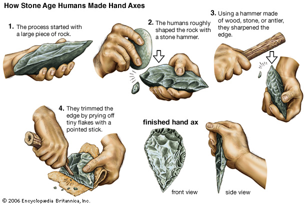


 Morocco’s capital city is Rabat; its largest city is its main port, Casablanca. Other cities recording a population over 500,000 in the 2014 Moroccan census are Fes, Marrakesh, Meknes, Salé and Tangier.


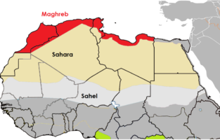 The indigenous – or native – people of North Africa are known as Berbers, and they make up the majority of Morocco’s population both in the modern day and throughout its three thousand year-old recorded history. The Berbers have historically been a people who practiced both settled agriculture and nomadic herding of animals. They have also developed extensive trade routes across the mountains and deserts of Morocco and North Africa generally, a region often referred to as the Maghreb. Berber society has historically been defined not by modern nation-states or empires, but by more local clans or tribes – extended familial and geographic identities. Modern Berbers are largely Sunni Muslim, but historically have practiced their own native religion, as well as Christianity and Judaism.


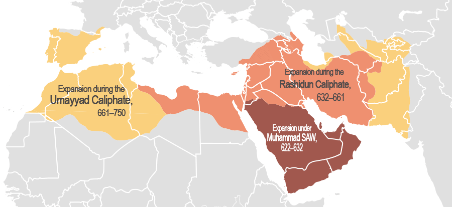
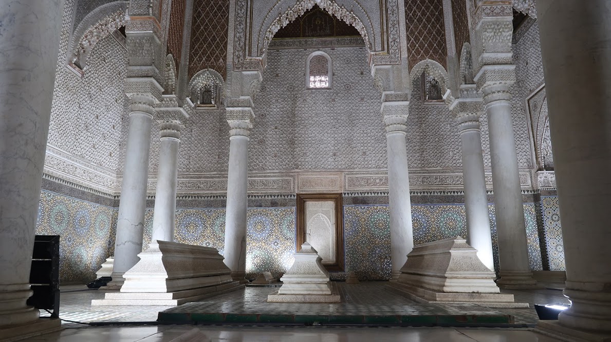
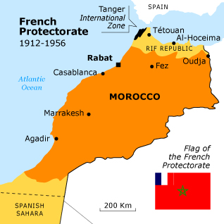


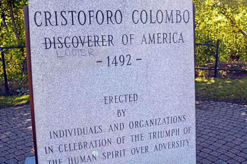


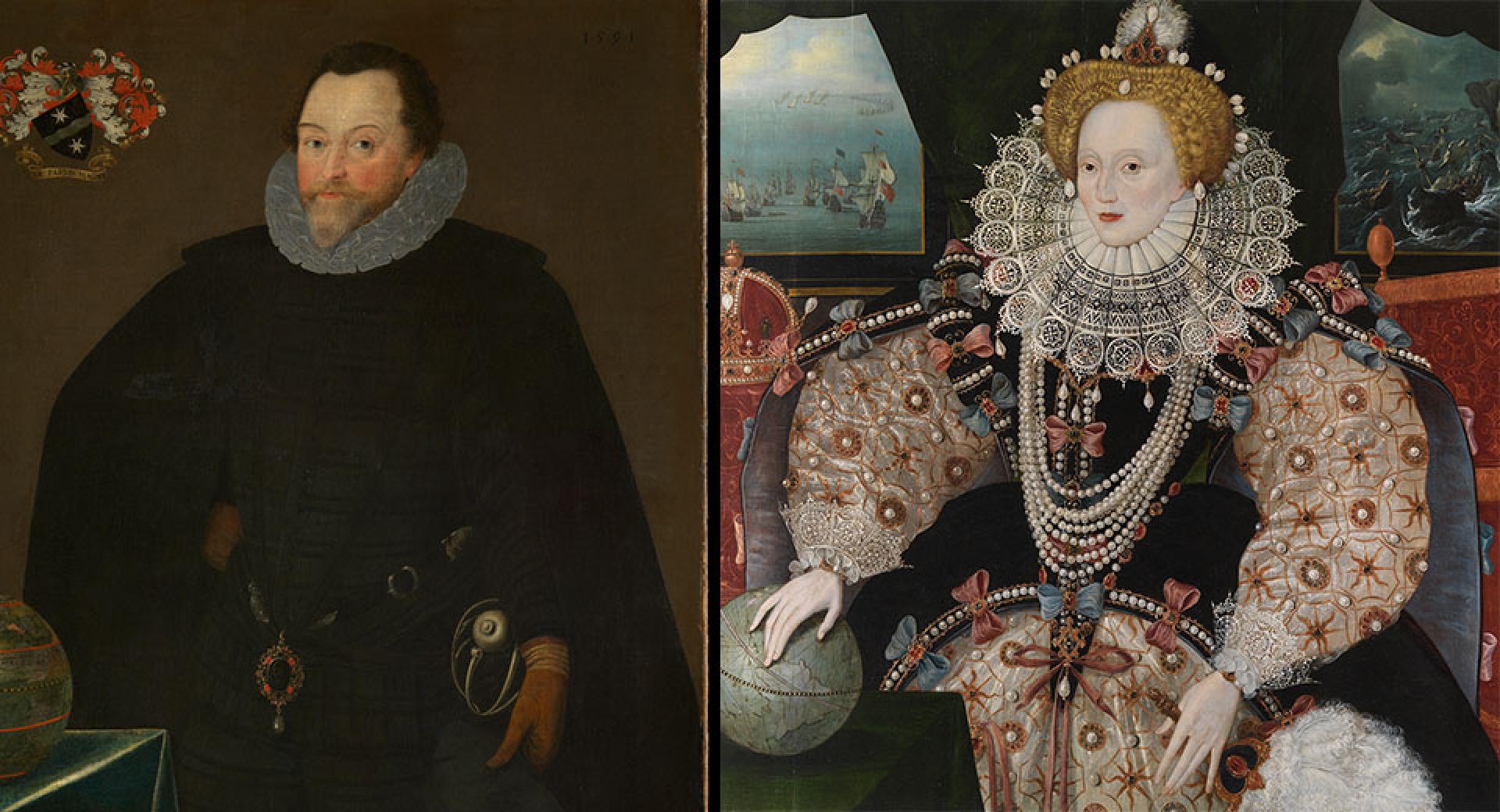


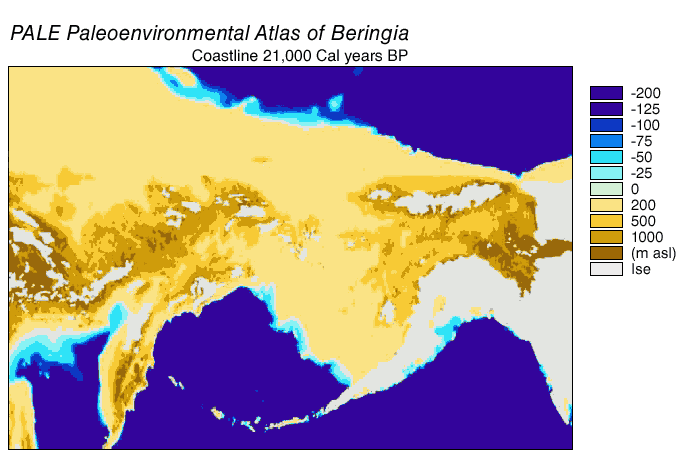


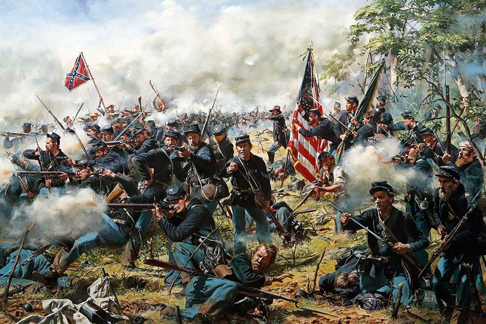

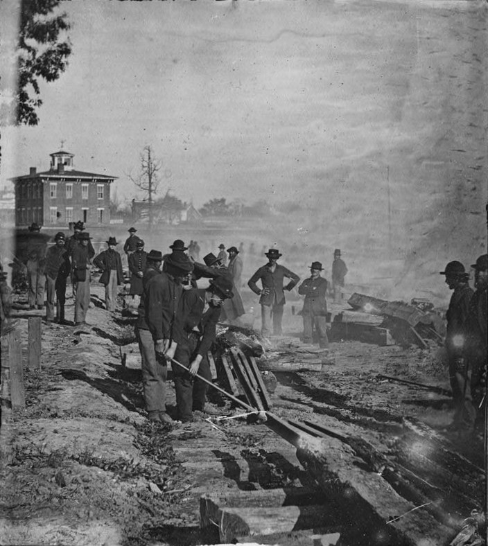


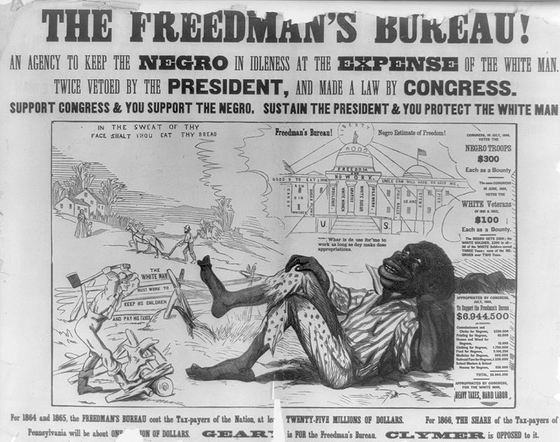


You must be logged in to post a comment.