An injustice against one of us is an injustice against all of us.
Black lives matter.
But here’s a sobering thought – at various early points in the history of our nation, certain people decided very consciously that they absolutely should not. And many of our modern institutions – from the police to the courts to the schools – were built on this cracked foundation.
The historical decisions that have shaped our moment are often invisible to us – like water to fish, we swim in the choices our ancestors have made.
But we when we realize that this is the case – that our reality is not set, but a sum total of historical choices – we become responsible for our own actions.
And then, we are truly free.
Here are a selection of free history lessons from our archives – suitable for middle or high school classrooms – that shed a light on our current moment. If you aren’t teaching lessons like these in your social studies classes, ask yourself – why not?
Comparing Slavery and Factory Life – Apologists for slavery often argued that, in their day at least, their system of slavery was better than free market capitalism. Let’s put that to the test… (primary source analysis with guided questions)
Were the Freedmen Really Free? – After the Civil War, Southerners sought to reconstruct slavery in everything but name. We are the direct inheritors of this system, which was only partly deconstructed in the 1950s and 60s. (primary source analysis with guided questions)
Social Reform Movements – Who Should Be the New Face of the $20 Bill? – Progress has always been earned, never granted. Give students the change to reimagine our national pantheon to include the social reformers and progressives who are often more responsible than any president or general for the way of life we cherish today. (research activity)
Do you have other relevant lessons? Share them – I would be honored to host them for free so that they can reach a wider audience! Reach out to me here.
Like most of you, I’ve suddenly found myself teaching online social studies classes. Good thing there’s a whole library of free lessons at Openendedsocialstudies.org, just ready and waiting to support your middle and high school world and US history needs. Please browse and share widely in your social circles.
Here’s a look at some lessons my own home-bound students will see in the twilight days of this school year, preempted so abruptly by our national quarantine. We’re trying to keep it light, airy, and most of all relevant.
Most to the point, we’re trying to teach these kids something about how to be a good, well-rounded person. Wasn’t that why you got into this business in the first place?
So, get your kids away from the computer screen as much as possible – that is where they’re going to be for math and ELA.
Everything below is written to apply to the town where I teach, but can easily be adapted to your hometown.
Good luck and be good to each other.
T
Founder, Openendsocialstudies.org
Day 1 – Map Your World
Make a hand drawn map of your home and your yard (if you have one.) Use a measuring tape (or improvise one if you don’t have a measuring tape.)
Your map should be to scale – 1 inch equals 5 feet. Include and label all rooms, windows, doors, and major trees and landscaping. Also include a compass rose and a key, if necessary.
Scan/take a photo of your map.
Day 2 – Plant Life
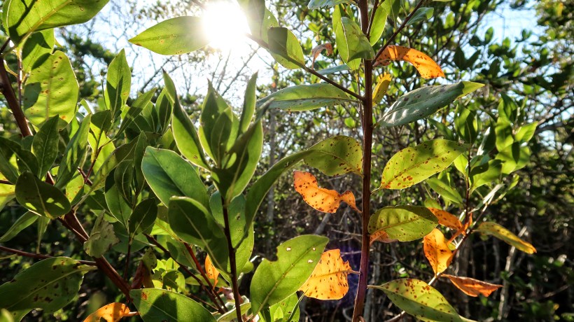
Pick a tree or plant in your yard. If you’re in an apartment, that’s ok – pick a plant/tree around your building.
Figure out what it is and write a brief report (in your own words, approximately one paragraph). Address questions about: the conditions under which it thrives, its relationship to humans (do we use it or its fruit or leaves for anything, or is it just for decoration), whether it is native to our state, whether your family planted it or it was growing there when you moved in.
You’ve got to be a detective for this one – describe the plant in Google image search, ask an adult who might know what it is, or download a leaf identification app on your phone (there are lots of free ones).
Day 3 – Ask an Adult
Ask an adult to tell you about the neighborhood they lived in when they were your age. Think of at least two related follow up questions. Document the answers in interview format – like this:
Student: Teacher, what am I supposed to do again?
Teacher: Interview an adult?
Student: Wait, what?
Teacher: Ask an adult some questions about the neighborhood they lived in when they were your age!
Student: That’s all?
Teacher: That’s all!
Day 4 – Read This
Read the following quote and respond to it in a five to eight sentence paragraph:
“Adults, in their dealing with children, are insane, and children know it too. Adults lay down rules they would not think of following, speak truths they do not believe. And yet they expect children to obey the rules, believe the truths, and admire and respect their parents for this nonsense. Children must be very wise and secret to tolerate adults at all. And the greatest nonsense of all that adults expect children to believe is that people learn by experience. No greater lie was ever revered. And its falseness is immediately discerned by children since their parents obviously have not learned anything by experience. Far from learning, adults simply become set in a maze of prejudices and dreams and sets of rules whose origins they do not know and would not dare inspect for fear the whole structure might topple over on them. I think children instinctively know this. Intelligent children learn to conceal their knowledge and keep free of this howling mania.”
― John Steinbeck, The Log from the Sea of Cortez
Day 5 – Dig a Hole
1.Find an out of the way space. Dig a hole at around a foot in depth. To provide a sense of scale, take a picture of your hole with a ruler or some other object in it.
2. Answer the following survey on your own sheet of paper:
Name:
Age:
Grade:
Teacher Who Made Me Do This and Their Email Address:
Best Friends:
Favorite Food:
Favorite Music:
What’s Going on in the World Right Now:
Advice to My Future Self:
3. Place your answers in a carefully sealed Ziploc bag, along with anything else you might want to bury in your time capsule.
4. Throw it in the hole, cover the hole, and dig it all up on April 1st in the year 2025 (or, before you move from your current house – whichever comes first). Write me a note when you do, and let me know how you’re doing!
Try to go easy on the grass – if you must dig through grass, you can usually cut a piece by getting your shovel up underneath it and levering it up. You can then replace it when you are done by dropping it back into place. If you are totally not allowed to dig, place this under a big rock, a paving stone, or somewhere else hidden.
Summarize the “Analysis” tab – what are your biggest impacts?
Were there any sources of carbon that you hadn’t considered before taking this survey?
Is there anything you could reasonably do to lessen your impact?
Day 7 – Eat a Piece of Fruit
Find a piece of fruit in your house. If you don’t have any, find something fruit flavored. Write a brief report on that piece of fruit, including information about its history and where it is cultivated.
3. How many sales are recorded for your home/when were they?
4. How has the value of your home changed over time?
Day 9 – Ask an Adult
Ask your adult to show you some photographs of his or her self when they were your age. Ask them three questions inspired by the photo. Record/document the answers in interview format.
Day 10 – Smoke Detectors
Find all the smoke detectors in your home. Get up on a chair and press the test button. They should make a loud noise. If they don’t, you need new batteries. You’re welcome. Send a photo of yourself up on the chair.
Day 11 – Record a Podcast
Using your phone or computer, record a short podcast (minimum two minutes) – on the theme “What is my life like while I’m stuck at home because of the Coronavirus?”
Day 12 – Make a Meal
Make or help to make breakfast, lunch, or dinner today for the members of your family. Submit a selfie of you in the kitchen/doing the work.
Day 13 – Native America
What Native American group occupied the land where you live now? Figure it out, give me a paragraph about them, and tell where I could can go to see some of their artifacts or the ruins of their towns.
Day 14 – Your Public Purpose
Read this article about the Californios Verdes – https://openendedsocialstudies.org/2019/04/19/californios-verdes-and-your-public-purpose-project/. The assignment at the end asks you to create a year long project. You don’t actually have to do this assignment – but if you DID have to do it, what kind of project would you take on? Describe it and why it is important to you in a five to eight sentence paragraph.
Day 15 – Sketch
Find something outside and sketch it. Your artwork doesn’t have to be “good” – but it must demonstrate effort. This shouldn’t take less than five minutes. Take a photo of yourself holding your sketch and upload it.
Day 16 – Your Officials
Who is your mayor? What is one thing he has done for the city? Who is your deputy mayor? Where is city hall?
Day 17 – In the Shade
Find a shady spot outside and read a book there for at least ten minutes. Take a selfie in your spot, with your book, and submit it.
Day 18 – Your Parks
Use Google Maps to help you pick a park or nature preserve. Write a one paragraph history of that place OR, if applicable, a one paragraph biography of the person it is named after.
Day 19 – Read This
Read the following quote and respond to it in a five to eight sentence paragraph:
‘We are what we pretend to be, so we must be careful about what we pretend to be.’
Day 20 – Surprise
Surprise me with your own act of creativity or whimsy – a hobby, a piece of art, an act of kindness, etc. It can be anything. Tell me about it/share a photo of it here, and tell me why you are proud of this thing.
“The best thing would be to take your students on a field trip every day – a world tour that throws light on experiences that most of your class can scarcely imagine. But of course, for so many reasons, that isn’t possible.
In the meantime, we educators have a duty to report the world back to our students – in all its unvarnished wonder. The great Mark Twain wrote, ‘Travel is fatal to prejudice, bigotry, and narrow-mindedness, and many of our people need it sorely…’
Are you teaching with the spirit of a traveler?”
Thomas Kenning, the creator of Openendedsocialstudies.org, has written an article which appears in this month’s issue of Teacher Plus magazine entitled “How to Teach like a Traveler.”
Check it out now, and check out our library of lessons designed to help you do just that!
This article lists many benefits of living in a medina – list them, adding any additional benefits that strike you. Then, create a list of drawbacks.
Should cities in your country build neighborhoods that look more like this? Would you live in one? Explain your answers.
Design your own ideal neighborhood – create a map that considers space to live, work, and play, as well as transportation and utilities like power and water. Why is this better than your current neighborhood?
A medina (from the Arabic: المدينة القديمة meaning “old city”) is an area found in many North African cities, including those in Morocco. A medina is comprised of a densely-packed collection of buildings, typically walled off from the outside world. It is usually accessible only by pedestrians through a handful of gates. Because the winding streets of a medina are rarely wider than the hallway in your school, they are generally off-limits to modern automobile traffic.
Medina quarters have usually been inhabited for a thousand years or more, and often contain historical public works – features important to the whole community – such as fountains for drinking water, schools, markets, shops, public squares, mosques, and churches. Traditionally, the medina was the city, and its residents rarely needed to leave its confines.
The medina of Chefchaouen, Morocco – densely clustered, multipurpose buildings, many of which are both homes and businesses. (Chefchaouen, Morocco, 2019.)
Aside from the addition of some electrical wires and modern plumbing, most modern medinas look a lot like they did in those bygone glory days of the trans-Saharan trade one thousand years past.
The streets are rarely wider that six or seven feet, and are sometimes as narrow as two or three. Mules and men with carts do most of the heavy lifting in the streets, delivering or carrying away what can’t be done by hand. In part because of the difficulty of moving bulky items without a motor vehicle, most people buy groceries for today, and maybe tomorrow, but rarely more. Furniture, modern appliances, and large construction supplies are often transported into the medina over a neighbor’s rooftop, then lowered down into a home through the central, open air courtyard. Anger your neighbors, and you might have a hard time remodeling your house.
Fresh fish – caught this morning – for sale in the souq, or market. It will likely be carried home by the purchaser, wrapped in yesterday’s newspaper. Sometimes a map pushing a cart full of iced fish will delivery it straight to residents’ doors.
Mosques – identifiable by their lighted minarets – serve each neighborhood within a medina, offering a space to pray, socialize, connect, and to resolve dispute with the community.
The crowded street of the medina in Fez. The ditch is in the center of the street, channeling water away from buildings and allowing pedestrians to stay dry even in the rain, beneath the awnings that are common in front of homes and shops.
In this cafe, refrigeration is provided by cool mountain water fed from a small mountain stream – there is no electricity.
Across North Africa and the Middle East, millions of people live this way in the modern day. It’s tempting for an American to view this life as old-fashioned, but that would be an ethnocentric point of view. That is, it would be evaluating other peoples and cultures according to the standards of one’s own culture. This can be a very limiting way to understand the world, because it often leads us to judge other societies unfairly. On the other hand, members of different societies might learn valuable lessons if they approach each others’ culture with an open mind. Someone learning about a different way of life in this way would not say “right” or “wrong,” but instead perhaps “different” and “similar,” “useful” or “not useful.”
So, instead, let’s try a thought experiment…
Don’t think of a medina as “backward.” Think of it as an example which might inspire an American to think about alternate, perhaps more healthier patterns for organizing our cities… What, at first glance, appear to be drawbacks to medina life, when described another way, are what many Americans list as desirable qualities in a neighborhood.
It is walkable, by necessity. Most anything you need – shopping, school, work, healthcare – is available in a five to ten minute walk from your door.
It is communal – there are basically no police present in the medina, so most problems are solved in the community. Violence is squashed through neighbors’ intervention and social pressure. Public fountains with fresh, safe drinking water can be found at most major intersections. Same with mosques, which, in addition to the streets lined with small, locally-owned shops, are at the center of residents’ spiritual and social lives.
Most all food is organic, fresh, and affordable, sold with zero plastic packaging.
The narrow streets are shaded between high-walled homes. As a result, temperatures within the medina are typically several degrees cooler than the open air outside of it. So, while most who live within the medina don’t have air conditioners, they don’t really need them either.
All of this means that the carbon footprint of the average medina dweller is much smaller – much more sustainable by many order of magnitude – than the average American.
Dusk falls on the densely packed medina of Fez. In this rooftop photo, it is easy to see the density, the open courtyards, and the mosques – recognizable from their tall towers – stretching into the distance.
Since there are few-to-no vehicles in the medina, the streets are designed for human traffic – stairways are common in mountain towns.
At their narrowest, the streets of the medina can be narrower than the hallway in your house. Extended families might build passover hallways to join two households across the street.
In an effort to maximize living space, some families build additions to their homes – which extend over the street. This does provide additional shade to pedestrians below.
The soul is the market section of the medina. Many small shops – usually highly specialized, selling only meat, only women’s clothing, only fruit, sometimes only one kind of fruit – characterize the shopping experience. All of this is within a few minutes walk from home.
Larger deliveries in the medina might be made to by mules. As a result, pedestrian fatalities – a real problem in every American community – are almost unheard of in the medina.
Occasionally, streets of the medina are wide enough to accommodate small motorbikes, such as this one making deliveries in the souk of Essaouira, Morocco.
For hundreds of years before running water was widely available to every home, Moroccan rulers built fountains at close intervals throughout the medina – fed sometimes by springs, sometimes by aqueducts carrying clean water from distant mountains to the corner by your house.
In Muslim countries, the symbol for a pharmacy is often the green crescent moon. This pharmacy serves a small neighborhood in the medina – and offers shade to pedestrians below.
A small public mailbox serves the neighborhood.
In the medina of Chefchaouen, residents have cultivated a vast, interwoven web of grape vines that grow overhead. The grapes can be eaten or turned into wine; their leaves provide fresh air and shade, and can also be eaten.
In the medina, streetlights are usually fixed overhead, right to the side of buildings – there is far less light pollution, because it takes far fewer lamps to light such narrow streets.
Electrical wires, added long after these ancient cities were originally built, are often run directly alongside buildings, or buried beneath the streets alongside waterlines.
Chickens often range freely, living on rooftops or in the courtyards of homes, providing fresh eggs and meat to their owners.
This public street runs completely underneath a multi-story home. Public parking typically means room for a bicycle or a hitch for a mule.
The public street continues into this tunnel.
Living in the medina can mean cramped corners, however. Each of these doors leads to a different home.
Traditional doors in the medinas of Morocco feature a smaller door nestled within a larger one, each with a seperate knocker which resonates with a distinct tone. The smaller door is for close family, as well as for ventilation while cooking – it allows for a modest amount of privacy within. The larger door is opened to welcome company or celebrate special occasion, symbolically opening the home to the wider community.
Air conditioning is rare in traditional medinas. Thick brick or mud walls and windows open at the right time of day help to keep indoor spaces cool.
This wall is made from sun-baked mud and straw, which insulates well against the heat of the day – and is durable in the arid, rainless climate that covers much of Morocco.
In most medinas, there are at least a few public squares filled with restaurants, shops, kids playing soccer, as well as musicians and other entertainers, such as snake charmers. Much of life outside of work and school takes place in open, public spaces like this square in Marrakesh, Morocco is by far one of the largest and busiest.
This cart is loaded with scrap metal for recycling. Any waste collection within the medina is done this way, on a human or mule-drawn carts. In truth, residents of the medina purchase most food without packaging in the local souq, meaning that they produce little inorganic waste. Large trash trucks are not really necessary here, even if they were possible.
Medinas are traditionally walled, guarding against attack from raiders or rival nations.
Industry can take place very close to residential areas. This tannery emits the strong smell of ammonia, which radiates for blocks around – neighbors live with it.
Without glamorizing social problems like poverty and sanitation issues that persist in some medinas (as they do in many American neighborhoods), it is easy to see why this way of life has persisted since prehistoric times.
On the other hand, the patterns of American suburbanization are barely a century and half old. They have led to many comforts for those fortunate enough to afford this lifestyle – but the American way of life is sometimes criticized for the social isolation encouraged by our preference for single family homes, by the unsustainable carbon emissions and lack of exercise encouraged by our urban sprawl, and for water wasted irrigating green lawns, even in parts of the country where grass does not naturally grow.
As we said earlier, there is no “right” or “wrong” when we attempt to look at cultures in this comparative way. But is it possible that Americans might learn valuable lessons from this way of life, persisting as it has with so little change since ancient times?
THIS LESSON WAS MADE POSSIBLE THROUGH A GENEROUS GRANT FROM THE QATAR FOUNDATION.
Citing specific examples, describe how the trans-Saharan trade linked Morocco to other regions of the world. Likewise, how does trade link your hometown to other regions of the world?
How does the camel make trans-Saharan trade possible? Throughout history, where and when have other animals extended or enhanced the potential of humans?
What factors lead to the rise of Islam in the West Africa? Consider ancient Morocco and your own country – how does joining a dominant religion or social group give advantages to converts, immigrants, or outsiders?
Taking inspiration from the griot tradition – using poetry, song, or visual art – tell the story of a journey along the trans-Saharan trade route from Timbuktu to Fez. Be as specific and tangible as you can. Represent the geography, the people, the trade goods, and anything else you might encounter on the way.
The Sahara Desert
The Sahara (Arabic: الصحراء الكبرى, aṣ-ṣaḥrāʾ al-kubrā , ‘the Greatest Desert’) is the largest hot desert and third largest desert after Antarctica and the Arctic worldwide. Its surface area is comparable to that of the United States. The desert comprises much of the land found within North Africa. The Sahara stretches from the Red Sea in the east and the Mediterranean in the north, to the Atlantic Ocean in the west, where the landscape gradually transitions to a coastal plain. To the south, it is bordered by the Sahel, a belt of semi-arid tropical savanna around the Niger River valley and Sudan Region of Sub-Saharan Africa – which was, from c. 1230 to c. 1600 – the homeland of the Mali Empire.
Morocco and the historic empires that preceded it have benefited greatly by controlling trade routes through the Atlas Mountains, which link the economies surrounding the Mediterranean Sea to those on the far side of the Sahara.
Increasing desertification and economic incentive
The Sahara once had a very different environment. In Libya and Algeria, from at least 7000 BC, there was pastoralism, herding of sheep and goats, large settlements and pottery. Cattle were introduced to the Central Sahara (Ahaggar) from 4000 to 3500 BC. Remarkable rock paintings (dated 3500 to 2500 BC), in places which are currently very dry, portray vegetation and animal presence rather different from modern expectations.
For several hundred thousand years, the Sahara has alternated between desert and savanna grassland in a 41,000 year cycle caused by the precession of the Earth’s axis as it rotates around the Sun, which changes the location of the North African Monsoon. The area is next expected to become green in about 15,000 years (17,000 AD). There is a suggestion that the last time that the Sahara was converted from savanna to desert it was partially due to overgrazing by the cattle of the local population.
As a desert, Sahara is now a hostile expanse that separates the Mediterranean economy from the economy of the Niger basin. Crossing such a zone (especially without mechanized transport like a train or truck) is worthwhile only when exceptional circumstances cause the expected gain to outweigh the cost and danger. The Sahara has always been home to groups of people practicing trade on a regular, if only local basis.
The Sahara covers 9 million square kilometres (3,500,000 sq mi), amounting to 31% of Africa. It is mainly rocky hamada (stone plateaus); ergs (sand seas – large areas covered with sand dunes, as pictured above) form only a minor part. Other distinctive features of the Sahara include gravel plains (reg), dry valleys (wadi), dry lakes (oued), and salt flats (shatt or chott).
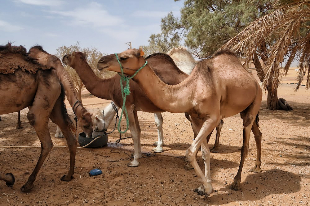
The Camel
Camels water before a short trek across a sand sea. Camels do not directly store water in their humps; they are reservoirs of fatty tissue. Concentrating body fat in their humps minimizes the insulating effect fat would have if distributed over the rest of their bodies, helping camels survive in hot climates. The dromedary camel can drink as seldom as once every 10 days even under very hot conditions, and can lose up to 30% of its body mass due to dehydration.
Although they rarely travel faster than the walking speed of a man, camels’ ability to withstand harsh conditions made them ideal for communication and trade in the desert areas of North Africa and the Arabian Peninsula for centuries, though they could only travel on routes with sufficient sources of food and water. The animals transformed the economy and culture of the Sahara.
Camels have a series of physiological adaptations that allow them to withstand long periods of time without any external source of water. Unlike other mammals, their red blood cells are oval rather than circular in shape. This facilitates the flow of red blood cells during dehydration and makes them better at withstanding high osmotic variation without rupturing when drinking large amounts of water: a 1,300 lb camel can drink 53 gallons of water in three minutes.
Camels can close their nostrils the same way humans can blink their eyes, an adaptation that allows them close out the sand that sometimes blows fiercely across the desert. Long eyelashes and ear hairs also form a barrier against sand. If sand gets lodged in their eyes, they can dislodge it using their transparent third eyelid.
When the camel exhales, water vapor becomes trapped in their nostrils and is reabsorbed into the body as a means to conserve water. Camels eating green herbage can ingest sufficient moisture in milder conditions to maintain their bodies’ hydrated state without the need for drinking.
Camels do not directly store water in their humps as was once commonly believed. The humps are actually reservoirs of fatty tissue: concentrating body fat in their humps minimizes the insulating effect fat would have if distributed over the rest of their bodies, helping camels survive in hot climates. When this tissue is metabolized, it yields more than one gram of water for every gram of fat processed.
Camels are able to withstand changes in body temperature and water consumption that would kill most other animals. Their body temperature ranges from 93 °F at dawn and steadily increases to 104 °F by sunset, before they cool off at night again. Maintaining the brain temperature within certain limits is critical for animals; to assist this, camels have a rete mirabile, a complex of arteries and veins lying very close to each other which utilizes countercurrent blood flow to cool blood flowing to the brain. Camels rarely sweat, even when ambient temperatures reach 120 °F.
Camels lying in sternal recumbency, a position that aids heat loss. Dromedaries have a pad of thick tissue over the sternum called the pedestal. When the animal lies down in a sternal recumbent position, the pedestal raises the body from the hot surface and allows cooling air to pass under the body.
Camels’ mouths have a thick leathery lining, allowing them to chew thorny desert plants. Camels eating green herbage can ingest sufficient moisture in milder conditions to maintain their bodies’ hydrated state without the need for drinking.
Camel’s feet are leathery and broad, distributing their weight over the sand more evenly – they can walk easily over sand that into which a horse’s hooves would sink.
Humans may have first domesticated dromedaries in Somalia and southern Arabia around 3,000 BC.
Camels’ mouths have a thick leathery lining, allowing them to chew thorny desert plants. Long eyelashes and ear hairs, together with nostrils that can close, form a barrier against sand. If sand gets lodged in their eyes, they can dislodge it using their transparent third eyelid. The camels’ gait and widened feet help them move without sinking into the sand. The kidneys and intestines of a camel are very efficient at reabsorbing water. Camel urine comes out as a thick syrup, and camel feces is so dry that they do not require any additional processing when desert peoples use them to fuel fires.
The Ultimate Desert Technology
People have been using camels for over 4,000 years mostly as pack animals and for transportation. Camels came to north Africa from Arabia, by way of Egypt and the Sudan, coming into widespread use by 300 CE, replacing horses and donkeys as the preferred means of transportation across the Sahara. A caravan of camels took 70 to 90 days to cross the Sahara, so the camel’s ability to travel long distances without water made trans-Saharan trade possible. In short, adoption of domesticated camels represented the ultimate in desert technology.
A funduq was a rest stop for merchants traveling along the Saharan trade routes. Most typically a funduq was a building with a square or rectangular walled exterior, with a single portal wide enough to permit large or heavily laden beasts such as camels to enter. The courtyard was almost always open to the sky, and the inside walls of the enclosure were outfitted with a number of identical animal stalls, bays, niches or chambers to accommodate merchants and their servants, animals, and merchandise. Funduqs provided water for human and animal consumption, washing and ritual purification – that is, washing before prayer or eating. Sometimes they had elaborate baths. They also kept fodder for animals and had shops for travelers where they could acquire new supplies. In addition, some shops bought goods from the travelling merchants.
The Sahara is dry and harsh – but resourceful humans learned long ago how to make the most of it to raise food and facilitate long distance trade. The location of oases has been of critical importance for trade and transportation routes in desert areas; caravans must travel via oases so that supplies of water and food can be replenished. Thus, political or military control of an oasis has in many cases meant control of trade on a particular route. People who live in an oasis must manage land and water use carefully; fields must be irrigated to grow plants like apricots, dates, figs, and olives. The most important plant in an oasis is the date palm, which forms the upper layer. These palm trees provide shade for smaller trees like peach trees, which form the middle layer. By growing plants in different layers, the farmers make best use of the soil and water. Many vegetables are also grown and some cereals, such as barley, millet, and wheat, are grown where there is more moisture.
Caravan Trade
Camels would be fattened for a number of months on the plains of either the Maghreb or the Sahel before being assembled into a caravan. According to Ibn Battuta, the famous Muslim explorer who accompanied one of the caravans, the average size per caravan was 1,000 camels; some caravans were as large as 12,000. Various Trans-Saharan trade routes connected sub- Saharan West Africa to the Mediterranean coast. Among the commodities carried southward were silk, cotton, horses, and salt. Among those carried northward were gold, ivory, pepper, and slaves.
Caravans would be guided by highly paid Berbers who knew the desert and could ensure safe passage from their fellow desert nomads. The survival of a caravan was precarious and would rely on careful coordination and knowledge of the land. Runners would be sent ahead to oases so that water could be shipped out to the caravan when it was still several days away, as the caravans could not easily carry enough with them to make the full journey.
Aït Benhaddou is an ighrem (fortified village in English) along the former caravan route between the Sahara and Marrakech in present-day Morocco. Such villages offered a walled refuge – complete with fresh water – for caravans traveling between Timbuktu and Marrakech, along the harsh Sahara trade routes.
Mediterranean economies were short of gold, but could supply salt, whereas West African countries had plenty of gold but needed salt. The trans-Saharan slave trade was also important because large numbers of Africans were sent north, generally to serve as domestic servants or slave concubines. The West African states imported highly trained slave soldiers. It has been estimated that from the 10th to the 19th century some 6,000 to 7,000 slaves were transported north each year. Perhaps as many as nine million slaves were exported along the trans-Saharan caravan route.
The Arrival of Islam
Merchants transported more than valuable commodities along the trans-Saharan routes. Just as Buddhism reached the Chinese Empire via Indian merchants traveling the Silk Road, Islam reached West Africa through Arab merchants on Saharan caravan routes. Arab merchants brought the Koran and the written language of Arabic to traditionally oral cultures in West Africa. The extensive trade networks throughout North and West Africa created a medium through which Islam spread peacefully, initially through the merchant class. By sharing a common religion and a common language (Arabic), traders showed greater willingness to trust, and therefore invest, in one another.
Sharing a meal, sharing a culture.
The British Museum describes the process of conversion in West Africa:
It was Arab traders who first brought the new religion to the kingdom of Mali. Many of them were educated and religious men who through speech and the books of learned writers managed to spread the word. Malians who became traders, and who moved further from their roots, began abandoning their old religion and adopting Islam which proved a passport for entry into northern markets. Traders were followed by Arab immigrants who came as judges, imams and teachers and who settled in the country. They were treated with respect and one Mansa (king) even married his daughters to two of them. Mosques were built, and Islamic influences were felt in architecture, poetry, cooking and even dress. Men were sent to study in Moroccan madrasas (religious schools). Timbuktu became a major centre of Islamic culture and learning. Even so, in the villages much of the old religion remained, and Ibn Battuta was shocked to discover, even at court, old ceremonial dances being performed during an Islamic religious festival.
The Great Mali Empire
During the 13th and 14th centuries, the great Mali Empire owed its prosperity to its position at the center of a network of caravan trade routes which criss-crossed West Africa, linking sub-Saharan Africa, the Islamic world, and the Mediterranean. The empire was founded in 13th Century by Sundiata Keita, whose exploits remain celebrated in Mali today.
Sundiata Keita
From the British Museum:
Sunjata (r. 1235–1255) was the first king to unify the Mandinka kingdoms and is as much a figure of legend as of fact. Epic songs of the griots tell of the ‘magician’ Sunjata who, when the Mandinka could no longer bear the burden of paying taxes to their Sosso leader Sumanguru, led them into battle. Sunjata killed Sumanguru at the Battle of Krina in 1235, and seized the major territories through which gold was traded. Sunjata declared himself Mansa (King of Kings) of the twelve kingdoms of the Mandinka. The 12 kings swore to obey Sunjata in return for being named governors of their territories. To help him rule, Sunjata set up a Gbara, or Great Assembly, of clan elders who would discuss and make decisions. Over the next two centuries the kingdom would expand through war, until it covered 1.3 million km2 . Sunjata’s successor Ali is credited with conquering the great trading centres of Timbuktu and Djenné.
An Oral History
A griot in modern Mali.
There are a few written accounts of this period, because West African society relied on a tradition of oral history passed down by griots (professional storytellers). Our picture of the Mali Empire comes mainly from the modern continuation of this oral tradition, archaeological research, the extant remains of cities, and the accounts of a few visiting writers.
In addition to royal griots who served the court, most villages also had their own griot, who told tales of births, deaths, marriages, battles, hunts, affairs, and hundreds of other things.
Francis Bebey writes about the griot in his book African Music, A People’s Art (Lawrence Hill Books):
“The West African griot is a troubadour, the counterpart of the medieval European minstrel… The griot knows everything that is going on… He is a living archive of the people’s traditions… The virtuoso talents of the griots command universal admiration. This virtuosity is the culmination of long years of study and hard work under the tuition of a teacher who is often a father or uncle.
Mali’s Economy
With an economy built on the basis of the trans-Saharan trade, the Mali Empire was the largest and longest lasting kingdom in the history of West Africa. It profoundly influenced the culture of the region through the spread of its language, laws and customs along the Niger River, which ran through the heart of the empire. The empire contained three immense gold mines – Bambuk, Boure and Galam within its borders, by some estimates accounting for nearly half the gold supply in Africa, Asia, and Europe from the 12th century on. The empire taxed every ounce of gold, copper, and salt that crossed its borders.
Gold
Gold nuggets were the exclusive property of the mansa (king), and were illegal to trade within his borders. All gold was immediately handed over to the imperial treasury in return for an equal value of gold dust. Gold dust had been weighed and bagged for use at least since the reign of the Ghana Empire. Mali borrowed the practice to stem inflation of the substance, since it was so prominent in the region. The most common measure for gold within the realm was the ambiguous mithqal (4.5 grams of gold). This term was used interchangeably with dinar, though it is unclear if coined currency was used in the empire. Gold dust was used all over the empire, but was not valued equally in all regions.
Panning for gold is still a common – if challenging – livelihood in some West African nations.
Slaves
Similar to Christianity of the time, Islamic Sharia law allowed slavery, but prohibited slavery involving other preexisting Muslims; as a result, the main target for slavery were the people who lived in the frontier areas of Islam in Africa, in the Sahara and Sahel. Bernard Lewis writes that “polytheists and idolaters were seen primarily as sources of slaves, to be imported into the Islamic world and molded in Islamic ways, and, since they possessed no religion of their own worth the mention, as natural recruits for Islam.”
Large numbers of Africans were sent north, generally to serve as domestic servants or slave concubines. The West African states imported highly trained slave soldiers. It has been estimated that from the 10th to the 19th century some 6,000 to 7,000 slaves were transported north each year.
Salt
Rock salt at the market in Mopti. It is sold here in slabs, broken and weighed, and packaged into smaller amounts.
The next great unit of exchange in the Mali Empire was salt. Salt was as valuable, if not more valuable than gold in Sub-Saharan Africa. Salt is produced in the Sahara (and has been for over 2½ thousand years-mentioned by Herodotus) at several places. Since ancient times, salt has been used to flavor and preserve food. Salt was either extracted from evaporating pools or mined from underground, left behind from dried up ancient seabeds. It was cut into pieces and spent on goods with close to equal buying power throughout the empire. While it was as good as gold in the north, it was even better in the south. Salt was relatively rare in the south. The northern region on the other hand had no shortage of salt. Every year merchants entered Mali via Oualata with camel loads of salt to sell in Niani. According to Ibn Battuta who visited Mali in the mid-14th century, one camel load of salt sold at the northern trading post of Walata for 8–10 mithkals of gold, but in Mali proper it was worth 20–30 ducats and sometimes even 40. One particular source of salt in the Mali empire were salt-mining sites located in Taghaza. Ibn Battuta wrote that in Taghaza there were no trees and there is only sand and the salt mines. Nobody lived in the area except the Musafa slaves who working to dug the salts and lived on imported dates, camel meat, and millet imported from the Sudan. The buildings were even constructed from slabs of salt and roofed with camel skins. The salt was dug from the ground and cut into thick slabs, two of which were loaded onto each camel where they will be taken south across the desert and sold.
Salt, mined from large deposits, is loaded onto boats on the Niger River.
No government can rule a nation if there is no economic activity to feed the people. Moroccan cities such as Fez and Marrakech appear to be landlocked on any map – they are nowhere near the ocean. But in a very real sense, they are ports on the edge of a great sea – the Sahara. Along with their neighbors to the south in Mali, the Berbers of Morocco became sailors on that sea, moving goods in great caravans on the backs of camels. Control of the last leg of the Saharan trade routes fueled the rise of Moroccan dynasties such as the Almoravids and Almohads. The people of Morocco have long benefitted from their unique geographic perch – building an enterprising and resourceful civilization based on trade that straddles the Mediterranean and sub-Saharan worlds.
This restaurant in modern day Fez was once a fantastic private residence – built and maintained by wealth hard-earned in the trans-Saharan trade.
One set among the dozens of front doors to the royal palace in Fez, each featuring intricate decorative work produced at great expense – again, paid for through taxes on the trans-Saharan trade.
This is the Al-Attarine madrasa – the ancient equivalent of a high school in the Muslim world. Built in Fez between 1323 and 1325, its stunning woodwork and stucco detailing were funded via tax revenue from the trans-Saharan trade.
THIS LESSON WAS MADE POSSIBLE THROUGH A GENEROUS GRANT FROM THE QATAR FOUNDATION.
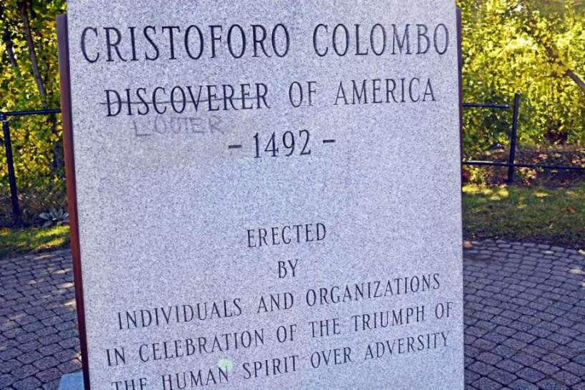
Who discovered America? As of this writing, Google gets the answer to that question wrong – while citing an article that gets it right. How can Columbus discover America if he was greeted on the beach? That would be like your friend arriving late to class, bursting through the door, and loudly proclaiming that he had discovered you, your teacher, and your peers. Columbus is certainly consequential. You can accurately say that he discovered the Americas for modern Europeans – but he was late to an already lively party. That party was in full swing, and, it can also be said that Columbus kicked off an unprecedented new era in American history characterized by conquest, colonialism, and exchange.
Why did Columbus think sailing west would lead him to Asia?
What was Columbus’s reaction to the indigenous peoples he encountered?
What is the Columbian Exchange?
In your opinion, was the large-scale death of Native Americans in the wake Spanish arrival an example of genocide?
How successful were early English efforts to profit from the Americas?
Listen to the children’s book as read in the video below. Compare and contrast the story told within to the one related in the text on this page. How do you account for the differences?Is it possible to understand Columbus from the storybook alone?
The Age of Discovery
During the fifteenth and the sixteenth century the states of Europe began their modern exploration of the world with a series of sea voyages. The Atlantic states of Spain and Portugal were foremost in this enterprise though other countries, notably England and the Netherlands, also took part. This period is known by historians as the Age of Discovery, or the Age of Exploration.
The Silk Road and spice trade routes later blocked by the Ottoman Empire in 1453 spurring exploration to find alternative sea routes.
The explorers of the fifteenth and sixteenth centuries had a variety of motivations, but were generally inspired by the prospects of trade and wealth – in particular, Portugal and Spain were motivated to circumvent Italian and Muslim merchants who controlled overland and maritime routes linking Europe, Africa, and Asia. The earliest explorations around the coast of West Africa were designed to bypass these trade routes. The improved naval techniques that developed from these experiments allowed Europeans to travel further afield, to India and, ultimately, to the Americas.
In 1492, a Spanish-based transatlantic maritime expedition led by Italian explorer Christopher Columbus (Cristoforo Colombo in his native language) encountered the Americas, continents which were completely unknown in Europe, Asia and Africa.
Contrary to popular belief, most educated Europeans of this period knew well enough that the world was round, a fact established through mathematical conjecture in ancient times by the Greeks and many others. Columbus was the first to sail west in search of the east because he believed that previous estimates about the size of the Earth were too large – he gambled that he could reach Asia before he and his crew ran out of fresh water in the open Atlantic. He was wrong, but it is accurate to say that his error ushered in the modern world.
A replica of the Niña, one of three ships used in Columbus’s 1492 journey. Technological advancements such as the adoption of the magnetic compass and the astrolabe, improved rudders, and sails made the Age of Discovery possible. The compass was invented by Chinese. It had been used for navigation in China by the 11th century and was adopted by the Arab traders in the Indian Ocean. The compass spread along trade routes to Europe by the late 12th or early 13th century.
Columbus’s crew sighted land on October 12, 1492. Columbus called the island San Salvador, in the present-day Bahamas or Turks and Caicos; the indigenous residents had named it Guanahani. Exactly which island in the Bahamas or Turks and Caicos this corresponds to is an unresolved topic.
The indigenous people he encountered, the Lucayan, Taíno, and Arawak, were peaceful and friendly. He called the inhabitants indios (Spanish for “Indians”). Noting their gold ear ornaments, Columbus took some of the Arawaks prisoner and insisted that they guide him to the source of the gold. From the entry in his journal of 12 October 1492, in which he wrote of them: “Many of the men I have seen have scars on their bodies, and when I made signs to them to find out how this happened, they indicated that people from other nearby islands come to San Salvador to capture them; they defend themselves the best they can. I believe that people from the mainland come here to take them as slaves. They ought to make good and skilled servants, for they repeat very quickly whatever we say to them. I think they can very easily be made Christians, for they seem to have no religion. If it pleases our Lord, I will take six of them to Your Highnesses when I depart, in order that they may learn our language.” Columbus noted that their primitive weapons and military tactics made them susceptible to easy conquest, writing, “these people are very simple in war-like matters … I could conquer the whole of them with 50 men, and govern them as I pleased.”
Landing of Columbus (12 October 1492), a painting by John Vanderlyn, is a heroic depiction of Columbus’s landfall in the Americas. Note the cowering, bowing natives in the shadows. In this light, Columbus is portrayed as bringing light and civilization to a hemisphere of savages. Long after his death, Columbus would become a hero to many, especially in United States during the latter part of the 1800s. This painting was commissioned for the Rotunda of the U.S. Capitol Building.
Since the late 20th century, historians have criticized Columbus for initiating colonization and for abuse of natives. Among reasons for this criticism is the poor treatment of the native Taíno people of Hispaniola, whose population declined rapidly after contact with the Spanish. As governor of the island, Columbus required the natives to pay tribute in gold and cotton. Modern estimates for the pre-Columbian population of Hispaniola are around 250,000–300,000. According to the historian Gonzalo Fernandez de Oviedo y Valdes, by 1548, 56 years after Columbus landed, and 42 years after he died, fewer than 500 Taíno were living on the island. The indigenous population declined rapidly, due primarily to the first pandemic of European endemic diseases, which struck Hispaniola after 1519. There is also ample documentation that they were overworked – subjected to deadly forced labor in gold and silver mines, as well as on large plantations called encomienda on a massive scale.
According to Spanish colonist and Dominican friar Bartolomé de las Casas’s contemporary A Short Account of the Destruction of the Indies, when slaves held in captivity began to die at high rates, Columbus ordered all natives over the age of thirteen to pay a hawk’s bell full of gold powder every three months. Natives who brought this amount to the Spanish were given a copper token to hang around their necks. The Spanish cut off the hands of those without tokens, and left them to bleed to death. Thousands of natives committed suicide by poison to escape their persecution.
The four voyages of Columbus began the Spanish colonization of the Americas. From the perspective of many non-Europeans, the Age of Discovery marked the arrival of invaders from previously unknown continents.
For a long time it was generally believed that Columbus and his crew had been the first Europeans to make landfall in the Americas. In fact they were not the first explorers from Europe to reach the Americas, having been preceded by the Viking expedition led by Leif Erikson in the 11th century; however, Columbus’s voyages were the ones that led to ongoing European contact with the Americas, inaugurating a period of exploration, conquest, and colonization whose effects and consequences persist to the present.
Beginning with the 1492 arrival of Christopher Columbus in the Caribbean and continuing control of vast territory for over three centuries, the Spanish Empire would expand across the Caribbean Islands, half of South America, most of Central America and much of North America (including present day Mexico, Florida and the Southwestern and Pacific Coastal regions of the United States).
Five hundred years of European colonial expansion, kicked off by Columbus on behalf of Spain in 1492.
European overseas exploration led to the rise of global trade and the European colonial empires, with the contact between the Old World (Europe, Asia and Africa) and the New World (the Americas and Australia) producing the Columbian Exchange, a wide transfer of plants, animals, food, human populations (including slaves), communicable diseases and culture between the Eastern and Western Hemispheres. This represented one of the most significant global events concerning ecology, agriculture and culture in history. The Age of Discovery and later European exploration allowed the global mapping of the world, resulting in a new worldview and distant civilizations coming into contact, but also led to the propagation of diseases that decimated populations not previously in contact with Eurasia and Africa and to the enslavement, exploitation, military conquest and economic dominance by Europe and its colonies over native populations.
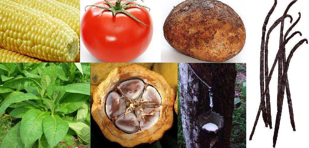
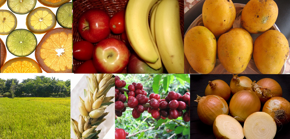
New World native plants. Clockwise, from top left: 1. Maize (Zea mays) 2. Tomato (Solanum lycopersicum) 3. Potato (Solanum tuberosum) 4. Vanilla (Vanilla) 5. Pará rubber tree (Hevea brasiliensis) 6. Cacao (Theobroma cacao) 7. Tobacco (Nicotiana rustica)Old World native plants. Clockwise, from top left: 1. Citrus (Rutaceae); 2. Apple (Malus domestica); 3. Banana (Musa); 4. Mango (Mangifera); 5. Onion (Allium); 6. Coffee (Coffea); 7. Wheat (Triticum spp.); 8. Rice (Oryza sativa)
The indigenous population of the Americas plummeted by an estimated 80% in the first century and a half following Columbus’s voyages, primarily through the spread of Afro-Eurasian diseases. This has been argued to be the first large-scale act of genocide in the modern era – the deliberate killing of a large group of people, especially those of a particular ethnic group or nation – although this claim is largely disputed due to the unintended nature of the disease introduction, which is considered a byproduct of Columbian exchange. Racial mixing was a central process in the Spanish colonization of the Americas, and ultimately led to the Latin American identity, which combines Hispanic, Native American, Arabic, Berber, and numerous African ethnicities.
Statues of Christopher Columbus are common throughout the world, especially in the United States. In the twenty-first century, veneration of Columbus has become increasingly controversial. This statue of Columbus is New York’s Central Park was defaced with red paint – representing blood on his hands.
English Competition in the Americas
At the time of Spain’s ascendancy, England was a relatively weak, small country on the periphery of Europe. In 1496, King Henry VII of England, following the successes of Spain and Portugal in overseas exploration, commissioned John Cabot to lead a voyage to discover a route to Asia via the North Atlantic. Cabot sailed in 1497, five years after the European discovery of America, but he made landfall on the coast of Newfoundland, and, mistakenly believing (like Christopher Columbus) that he had reached Asia, there was no attempt to found a colony. Cabot led another voyage to the Americas the following year but nothing was ever heard of his ships again.
No further attempts to establish English colonies in the Americas were made until well into the reign of Queen Elizabeth I, during the last decades of the 16th century. During this time, conflict between England and Spain grew, fueled mainly by English piracy and religious differences.
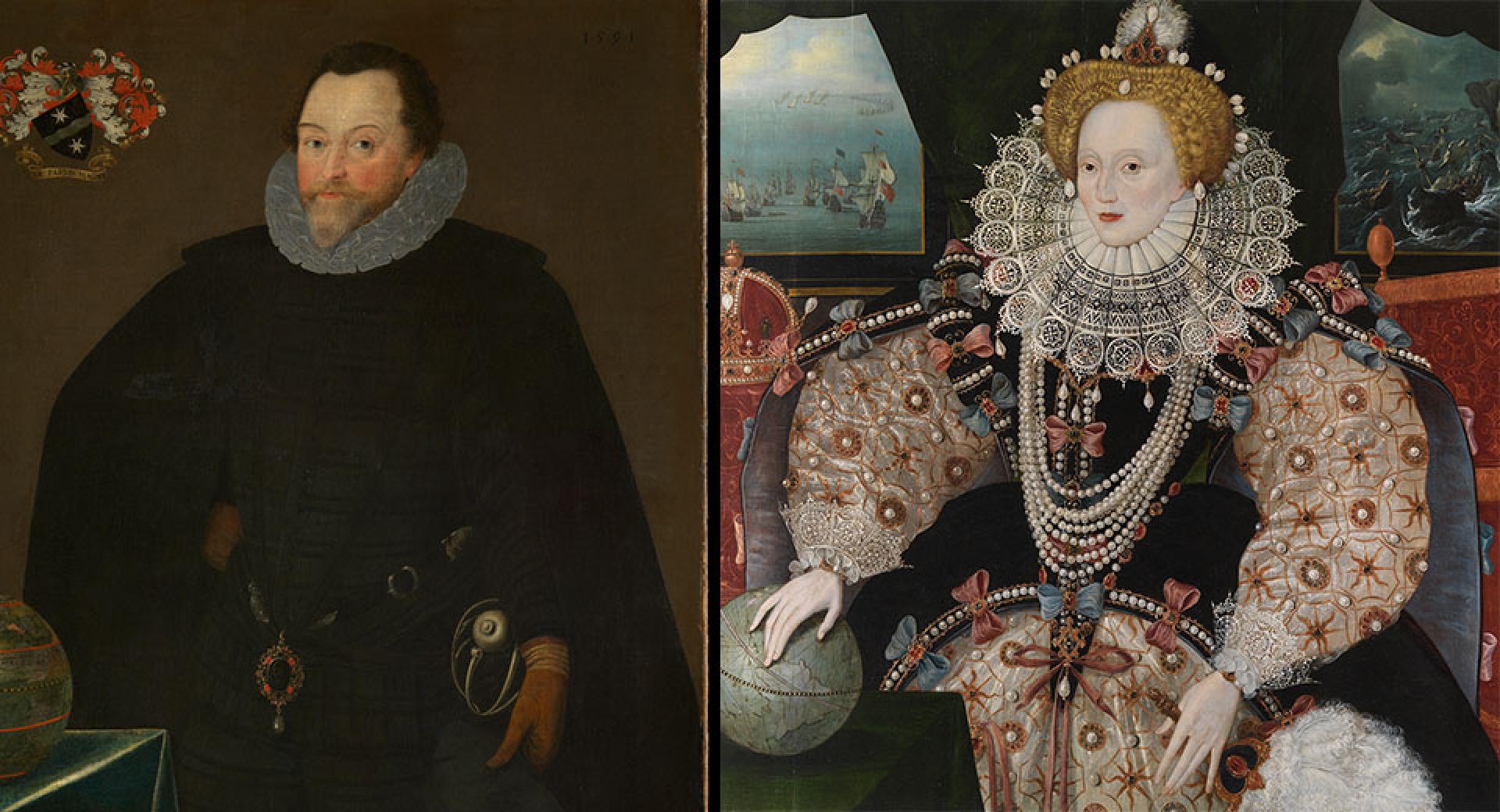
Sir Francis Drake by Marcus Gheeraerts (1591) and the Armada Portrait of Elizabeth I.
In 1562, the English Crown encouraged the privateers – pirates operating on behalf of a country – John Hawkins and Francis Drake to engage in slave-raiding attacks against Spanish and Portuguese ships off the coast of West Africa with the aim of breaking into the Atlantic slave trade. This effort was rebuffed and later, as the Anglo-Spanish Wars intensified, Elizabeth I gave her blessing to further privateering raids against Spanish ports in the Americas and shipping that was returning across the Atlantic, laden with treasure from the New World.
The Roanoke Colony was the first attempt at founding a permanent English settlement in North America. It was established in 1585 on Roanoke Island in what is now Dare County, North Carolina, United States.
The initial settlement was established in the summer of 1585, but a lack of supplies and bad relations with the local Native Americans caused many of its members to return to England with Sir Francis Drake a year later, leaving behind a small detachment. These men had all disappeared by the time a second expedition led by John White, who also served as the colony’s governor, arrived in July 1587. White, whose granddaughter Virginia Dare was born there shortly thereafter (making her the first English child born in the New World), left for England in late 1587 to request assistance from the government, but was prevented from returning to Roanoke until August 1590 due to the Anglo-Spanish War. Upon his arrival, the entire colony was missing with only a single clue to indicate what happened to them: the word “CROATOAN” carved into a tree.
The discovery of the word “Croatoan” carved onto a stockade board.
For many years, it was widely accepted that the colonists were massacred by local tribes, but no bodies were ever discovered, nor any other archaeological evidence. The most prevalent hypothesis now is that environmental circumstances forced the colonists to take shelter with local tribes, but that is mostly based on oral histories and also lacks conclusive evidence. Some artifacts were discovered in 1998 on Hatteras Island where the Croatan tribe was based, but researchers could not definitively say these were from the Roanoke colonists.
“And that support crosses political divides, according to the results of an exclusive new NPR/Ipsos poll: Whether they have children or not, two-thirds of Republicans and 9 in 10 Democrats agree that the subject needs to be taught in school.
A separate poll of teachers found that they are even more supportive, in theory — 86% agree that climate change should be taught.”
Californios Verdes and Your Public Purpose Project: Can young people change the world, or are they stuck with the messy one that adults are planning to hand to them? Learn about the Californios Verdes, a group of young people inspired to take action on behalf of the environment in their hometown of La Paz, Mexico. Based on this model, students will devise their own public purpose project – a year-long project devised and carried out by students to improve quality of life, raise environmental awareness, or in some other way positively impact their community.
Where do you fit into Earth’s Ecosystems? (Even the Ones You’ve Never Seen with Your Own Two Eyes): Read about John Steinbeck, the American author who took part in a voyage to collect scientific samples of species in the Sea of Cortez. His vivid writing is an entry point for students into a discussion of ecosystems, ecosystem goods and services, and human impacts on ecosystems. Afterwards, students will apply these concepts to surveying, quantifying, and mapping their own ecological footprint.
Unrecognized Potential: Terra Preta, Ancient Orchards, and Life in the Amazon: Until relatively recently, it was widely believed that the Amazon Rainforest was incapable of sustaining large scale human development. New findings have challenged this view, and evidence of ancient agriculture suggests that humans once developed this fragile region in ways so subtle that – in the form of carefully managed soils and prehistoric orchards – they have been hiding in plain sight all this time, challenging the basic tenants of “agriculture” as western eyes tend to recognize it.
The Pristine Myth: How Native Americans Shaped Their World (Free online text suited for middle or high school classroom use, guided reading questions, and suggested activities) For millennia before the arrival of Columbus, Native Americans shaped the environment around them to suit their needs, often in ways that were invisible from a European perspective.
The Three Sisters: Background information on the agricultural combination of maize (corn), beans, and squash that formed the backbone of the Mesoamerican and North American civilization, plus suggested activities.
“Let us go into the Sea of Cortez, realizing that we become forever a part of it; that our rubber boots slogging through a flat of eel-grass, that the rocks we turn over in a tide pool, make us truly and permanently a factor in the ecology of the region. We shall take something away from it, but we shall leave something too. And if we seem a small factor in a huge pattern, nevertheless it is of relative importance. We take a tiny colony of soft corals from a rock in a little water world. And that isn’t terribly important to the tide pool. Fifty miles away […] shrimp boats are dredging with overlapping scoops, bringing up tons of shrimps, rapidly destroying the species so that it may never come back, and with the species destroying the ecological balance of the whole region. That isn’t very important in the world. And thousands of miles away the great bombs are falling and the stars are not moved thereby. None of it is important or all of it is.” – John Steinbeck
This lesson was reported from:
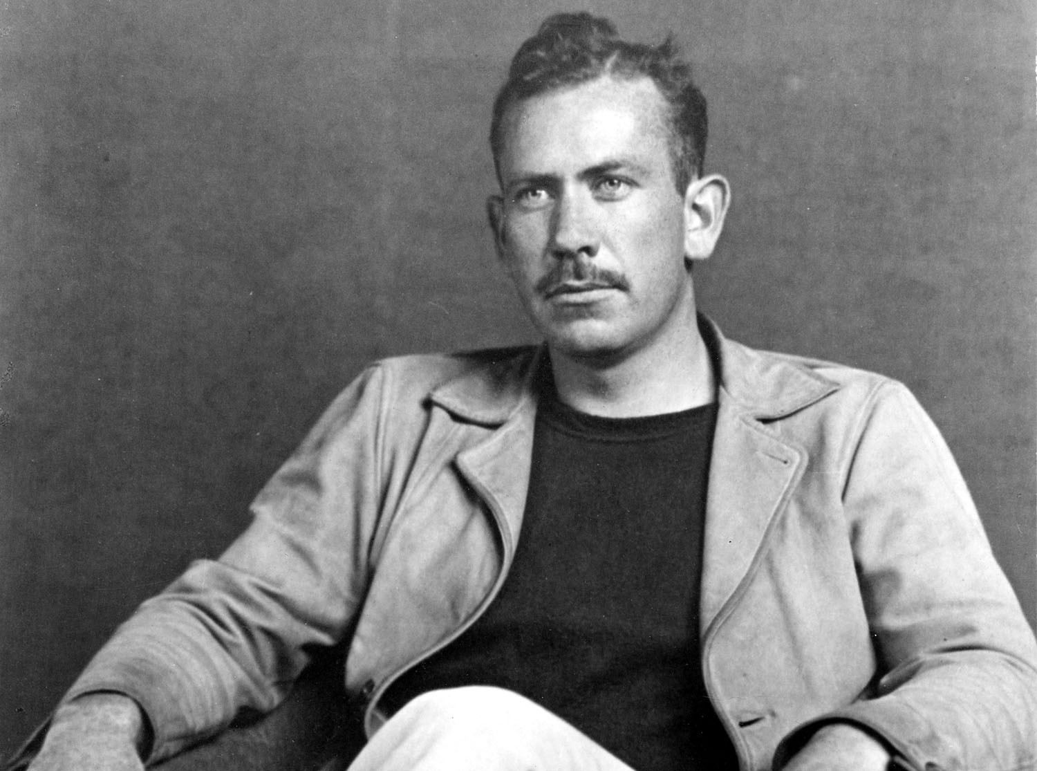
In 1940, the author John Steinbeck joined an expedition to the Sea of Cortez, also known as the Gulf of California, with his friend, the marine biologist Ed Ricketts. Their purpose was scientific – they wished to document and understand the ecology of the Sea of Cortez. They traveled with a small crew aboard a 75-foot boat named the Western Flyer, collecting scientific samples and data of the fauna they encountered, all with the goal of writing a scientific guidebook – one part species catalog, one part travel adventure – entitled Sea of Cortez: A Leisurely Journal of Travel and Research. (1941)
John Ernst Steinbeck Jr. (February 27, 1902 – December 20, 1968) was an American author. He won the 1962 Nobel Prize in Literature “for his realistic and imaginative writings, combining as they do sympathetic humor and keen social perception.” He has been called “a giant of American letters,” and many of his works – Of Mice and Men, The Grapes of Wrath, The Pearl – are considered classics of Western literature. (Wikipedia)
First edition of The Log from the Sea of Cortez by John Steinbeck, 1951.
The book describes the complex ecosystem of the Sea of Cortez, its islands, and shorelines. An ecosystem is a community of living organisms interacting with the nonliving components of their environment. Steinbeck describes the wildlife – in particular, the marine invertebrates – in colorful detail, but Sea of Cortez is perhaps most notable for placing humans and human activity firmly into his poetic take on ecology. After all, humans inhabit the Sea of Cortez, they fish in it, they mine the surrounding mountains, their carbon emissions and plastic waste from thousands of miles away effect it – humans should not be considered apart from its ecology.
Humans engage in complex interactions with ecosystems – both those in their immediate surroundings, where they live and work, and those on the other side of the planet, in areas that supply commercial goods that they consume or that are effected by greenhouse emissions. (Isla Espíritu Santo, Mexico, 2019.)(Enlarge and open in a new window.)
In fact, human activities are a significant factor in almost all of Earth’s ecosystems. The cumulative effects of their impact are large even enough to influence the planet’s climate, or patterns of weather over long periods of time.
Ecosystems provide a variety of goods and services upon which people depend. Ecosystem goods include food (fishing, for example), construction material (lumber from forests, sand, stone from quarries, metals from mines, plastics from petroleum pumped from deep under the Earth), and medicinal plants (aspirin, quinine, marijuana). Ecosystem goods also include less tangible items like tourism and outdoor recreation, staples of the economy in many communities around the globe.
Ecosystem services, on the other hand, are the many and varied benefits that humans gain from the natural environment and from properly-functioning ecosystems. These include clean air and water (thanks to plants which capture CO2 and aquifers which filter rain water) and crop pollination (by insects and birds). Even things like beauty, inspiration, and opportunities for scientific research, which help humans to better understand our world.
In addition to providing a home (habitat) for a great variety of other species, mangrove swamps protect coastal areas from erosion, storm surge (especially during hurricanes), and tsunamis – a great example of ecosystem services in action. (Florida Everglades at low tide, 2018.)
While ecosystem goods have traditionally been recognized as the basis for things of economic value – they are property and goods that one can own – ecosystem services tend to be taken for granted – available to all, whether one “owns” the forest or not. Ecosystem services are what an economist might call a public good – something shared more or less equally by everyone for free. Since they do not cost money, our capitalist system has traditionally placed little value on protecting them – even though they are vital to life as we know it.
In Sea of Cortez, Steinbeck connects the dots between ecosystem goods, ecosystem services, and human activity. While he was not the first to connect humans to the ecosystems they inhabit and exploit, his writing on the subject is both eloquent and persuasive. Early in the book, he writes:
“Let us go into the Sea of Cortez, realizing that we become forever a part of it; that our rubber boots slogging through a flat of eel-grass, that the rocks we turn over in a tide pool, make us truly and permanently a factor in the ecology of the region. We shall take something away from it, but we shall leave something too. And if we seem a small factor in a huge pattern, nevertheless it is of relative importance. We take a tiny colony of soft corals from a rock in a little water world. And that isn’t terribly important to the tide pool. Fifty miles away […] shrimp boats are dredging with overlapping scoops, bringing up tons of shrimps, rapidly destroying the species so that it may never come back, and with the species destroying the ecological balance of the whole region. That isn’t very important in the world. And thousands of miles away the great bombs are falling and the stars are not moved thereby. None of it is important or all of it is.”
The Earth can seem huge on a cross country drive that takes days, but it is actually finite. Its natural resources are vulnerable and limited. As human population and per capita consumption grow, so do the demands imposed on ecosystems and the effects of the human ecological footprint – that is, the impact of humanity on the global ecosystem in terms of carbon released, energy used, water consumed, and waste created.
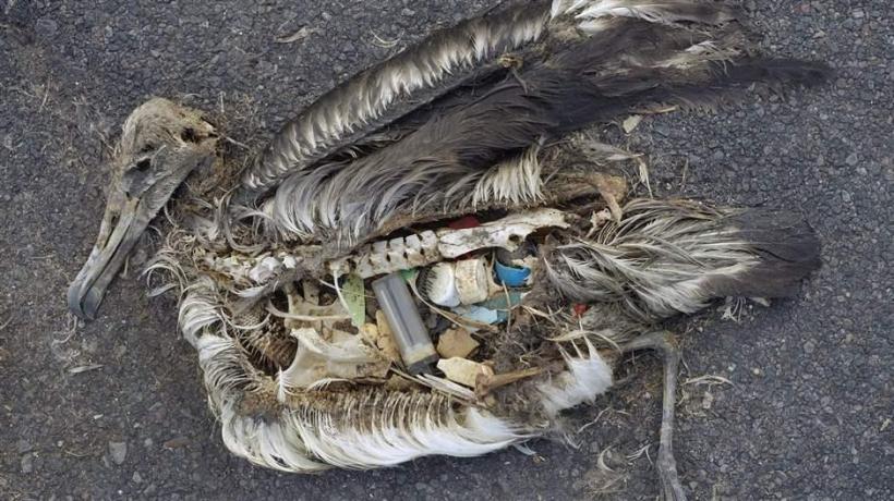
Ecosystem services are not only limited but also that they are threatened by human activities. Problems for all ecosystems include: environmental pollution, climate change, and biodiversity loss. For terrestrial ecosystems, additional threats include air pollution (chemicals released by manufacturing and power generation, emission of greenhouse gases), soil degradation (erosion from farming, salinization from irrigation, conversion of ecosystems for human construction projects), and deforestation (especially in tropical and coastal regions). For marine ecosystems threats include unsustainable exploitation of marine resources (overfishing of certain species), marine pollution (from deep sea oil drilling or spills), microplastics pollution (plastic takes thousands of years to biodegrade and too often ends up floating in the ocean), water pollution (from urban runoff and industrial manufacturing), and building on coastal areas.
Scientists have been conducting research for decades to help us better understand long-term ecosystem health and its role in enabling human habitation and economic activity. In a capitalistic democracy like the United States – where the priorities of both corporations and government are responsive to the will of the majority of people – it is important for all citizens to understand the findings of these scientists. Each of us must begin to recognize the way our habits of consumption impact on the ecosystems in our region, as well as – in a globalized economy threatened by climate change – ecosystems on the other side of the planet.
Downtown La Paz is beautiful, just like the downtown of your city, but human development shapes ecosystems as well. Earth, rock, and sand are paved over, waves and tidal action are broken, buildings and pavement reflect or trap heat and rain, runoff from roads after a rain can carry oil, plastic wastes, and other pollutants into otherwise clean waters. (La Paz, Mexico, 2019.)
Humans have the unique ability to shape our environment. This is one thing that distinguishes us from our fellow animals and plants.
Alongside this ability to shape, we also have the ability to ask and answer complex questions through careful observation of the world around us – this is what we can science. Elsewhere in Sea of Cortez, John Steinbeck said, “It is not enough to say that we cannot know or judge because all the information is not in. The process of gathering knowledge does not lead to knowing. A child’s world spreads only a little beyond his understanding while that of a great scientist thrusts outward immeasurably. An answer is invariably the parent of a great family of new questions. So we draw worlds and fit them like tracings against the world about us, and crumple them when they do not fit and draw new ones.”
As we begin to better understand the world around us, we find ourselves confronted with the uncomfortable truth that some of our activities as a species have damaged – and continue to damage – the ecosystems on which all life depends.
Modern technology has only enhanced these abilities to shape and to understand – just as it has enhanced our responsibility to create a sustainable future for our species and all others on this planet.
A handful of sand from the bottom of Candelero Bay on Isla Espíritu Santo reveals an entire ecosystem of marine worms living underfoot and, for most people, out of mind. (Isla Espíritu Santo, Mexico, 2019.)
For Writing or Discussion
1. What is an ecosystem? What goods and services do humans extract from them? What negative impacts do human activities have on them?
2. Describe an ecosystem in or near your hometown – name species of plants and animals, describe the average temperature, rainfall, etc in winter and summer. How have humans shaped this ecosystem and for what reasons?
3. In your own words, what does Steinbeck mean when he says “None of it is important or all of it is?” Do you agree with this sentiment?
4. Amongst life on Earth, human beings possess a unique level of self-awareness, as well as an unparalleled ability to shape every ecosystem on the planet for better or worse. Does that power come with any responsibility? Defend your answer.
Calculate Your Ecological Footprint
Trace your impact outward into the environment — list and categorize all of the (a) trash (paper, plastic, metal, recyclable or not), (b) carbon emissions (from electricity use, transportation, ordering things off of Amazon, etc), and (c) food/water (including showers, toilet flushes, and the sprinkler on your lawn) you consumed today. Be thorough and precise.
Quantify each of these impacts — weigh them, measure them, use information from the internet to estimate them. There are many tools online that can help you to calculate these numbers. Represent this information in charts or diagrams.
Incorporating information compiled in steps one and two, create a world map infographic or poster showing the origin points and impact points of your ecological footprint. Also, plot and illustrate the ways in which those points will effect you. For example: Where does your food come from? How is it transported to you? Is it refrigerated on the way? What is the carbon impact of these activities? What kind of biomagnification (plastics, pesticides, antibiotics, etc) is present in your diet? Was the tuna you may have eaten farmed or caught wild? Where? Is the current population of that fish in the wild sustainable?How many MPG does your car get? How far do you live from school? How long did your mom idle in carline? What temperature is the AC in your how many square foot house? Where do the plastics you trash end up? Where does the water in your toilet go after you flush? What effect does carbon have on the ice caps? Sea level? Acidification of the ocean? Where does your waste water go? What does your clean water come from? How will rising sea levels due to increased greenhouse activity impact your hometown? etc
In a reflective essay: Which of these impacts can you reduce through personal choices? What challenges or barriers to change will you encounter? Which of these impacts can only be reduced through government or corporate action?
Take It Further
Identify three concrete steps you will take to reduce your ecological footprint. This online quiz may help you. Describe exactly how you plan to take these steps. Resolve to carry them out for the next month.
. Describe exactly how you plan to take these steps. Resolve to carry them out for the next month.
If you value the free resources we offer, please consider making a modest contribution to keep this site going and growing.
John Steinbeck visited Isla Espíritu Santo, an island in the Gulf of California, off the Mexican state of Baja California Sur. Wikipedia describes ecosystems in the surrounding reefs as being home to parrotfish, angelfish, trumpetfish, Moorish idols, and rainbow wrasse, with many other species passing nearby including sharks, rays, turtles, dolphins, and whales. Birds who call the island home include brown pelicans, great blue herons, snowy egrets, turkey vultures, and hummingbirds. A large sea lion colony resides nearby. By the 1990s pressure to develop on Isla Espiritu Santo was intense: a real estate developer wanted to create a resort casino on the island. Tim Means, a conservationist based in nearby La Paz, formed a coalition of activists who were able to purchase part of the island from the ejido (farming commune) that wished to sell it to the developer. One third of the funds came from Mexican funders, another third from American funders via the Nature Conservancy, and the rest through an anonymous gift to the World Wildlife Fund. Today,Isla Espíritu Santo is protected as part of the Área de Protección de Flora y Fauna – Islas del Golfo de California. (Isla Espíritu Santo, Mexico, 2019.)
“The best thing would be to take your students on a field trip every day – a world tour that throws light on experiences that most of your class can scarcely imagine. But of course, for so many reasons, that isn’t possible.
In the meantime, we educators have a duty to report the world back to our students – in all its unvarnished wonder. The great Mark Twain wrote, ‘Travel is fatal to prejudice, bigotry, and narrow-mindedness, and many of our people need it sorely…’
Are you teaching with the spirit of a traveler?”
Thomas Kenning, the creator of Openendedsocialstudies.org, has written an article which appears in this month’s issue of Teacher Plus magazine entitled “How to Teach like a Traveler.”
Check it out now, and check out our library of lessons designed to help you do just that!


You must be logged in to post a comment.