The Sahara, the Camel, and the Caravan Trade

This lesson was reported from:

For Your Consideration:
  1. Citing specific examples, describe how the trans-Saharan trade linked Morocco to other regions of the world.  Likewise, how does trade link your hometown to other regions of the world?
  2. How does the camel make trans-Saharan trade possible?  Throughout history, where and when have other animals extended or enhanced the potential of humans?
  3. What factors lead to the rise of Islam in the West Africa?  Consider ancient Morocco and your own country – how does joining a dominant religion or social group give advantages to converts, immigrants, or outsiders?
  4. Taking inspiration from the griot tradition – using poetry, song, or visual art – tell the story of a journey along the trans-Saharan trade route from Timbuktu to Fez.  Be as specific and tangible as you can. Represent the geography, the people, the trade goods, and anything else you might encounter on the way.

The Sahara Desert

The Sahara (Arabic: الصحراء الكبرى‎, aṣ-ṣaḥrāʾ al-kubrā , ‘the Greatest Desert’) is the largest hot desert and third largest desert after Antarctica and the Arctic worldwide. Its surface area is comparable to that of the United States. The desert comprises much of the land found within North Africa. The Sahara stretches from the Red Sea in the east and the Mediterranean in the north, to the Atlantic Ocean in the west, where the landscape gradually transitions to a coastal plain. To the south, it is bordered by the Sahel, a belt of semi-arid tropical savanna around the Niger River valley and Sudan Region of Sub-Saharan Africa – which was, from c. 1230 to c. 1600 – the homeland of the Mali Empire.

Morocco and the historic empires that preceded it have benefited greatly by controlling trade routes through the Atlas Mountains, which link the economies surrounding the Mediterranean Sea to those on the far side of the Sahara.

map

Increasing desertification and economic incentive

The Sahara once had a very different environment. In Libya and Algeria, from at least 7000 BC, there was pastoralism, herding of sheep and goats, large settlements and pottery. Cattle wprehistoricere introduced to the Central Sahara (Ahaggar) from 4000 to 3500 BC. Remarkable rock paintings (dated 3500 to 2500 BC), in places which are currently very dry, portray vegetation and animal presence rather different from modern expectations.

For several hundred thousand years, the Sahara has alternated between desert and savanna grassland in a 41,000 year cycle caused by the precession of the Earth’s axis as it rotates around the Sun, which changes the location of the North African Monsoon. The area is next expected to become green in about 15,000 years (17,000 AD). There is a suggestion that the last time that the Sahara was converted from savanna to desert it was partially due to overgrazing by the cattle of the local population.

As a desert, Sahara is now a hostile expanse that separates the Mediterranean economy from the economy of the Niger basin. Crossing such a zone (especially without mechanized transport like a train or truck) is worthwhile only when exceptional circumstances cause the expected gain to outweigh the cost and danger. The Sahara has always been home to groups of people practicing trade on a regular, if only local basis.

berber desert
The Sahara covers 9 million square kilometres (3,500,000 sq mi), amounting to 31% of Africa.  It  is mainly rocky hamada (stone plateaus); ergs (sand seas – large areas covered with sand dunes, as pictured above) form only a minor part.  Other distinctive features of the Sahara include gravel plains (reg), dry valleys (wadi), dry lakes (oued), and salt flats (shatt or chott).
The Camel
IMG_4473
Camels water before a short trek across a sand sea. Camels do not directly store water in their humps; they are reservoirs of fatty tissue. Concentrating body fat in their humps minimizes the insulating effect fat would have if distributed over the rest of their bodies, helping camels survive in hot climates. The dromedary camel can drink as seldom as once every 10 days even under very hot conditions, and can lose up to 30% of its body mass due to dehydration.

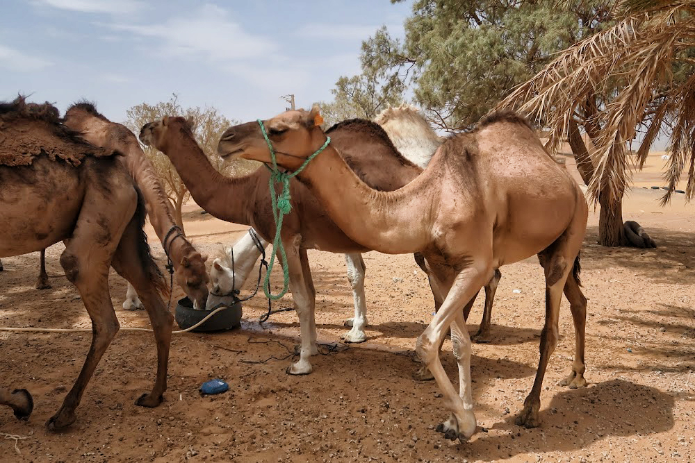
Although they rarely travel faster than the walking speed of a man, camels’ ability to withstand harsh conditions made them ideal for communication and trade in the desert areas of North Africa and the Arabian Peninsula for centuries, though they could only travel on routes with sufficient sources of food and water. The animals transformed the economy and culture of the Sahara.

Camels have a series of physiological adaptations that allow them to withstand long periods of time without any external source of water. Unlike other mammals, their red blood cells are oval rather than circular in shape. This facilitates the flow of red blood cells during dehydration and makes them better at withstanding high osmotic variation without rupturing when drinking large amounts of water: a 1,300 lb camel can drink 53 gallons of water in three minutes.

IMG_4621
Camels can close their nostrils the same way humans can blink their eyes, an adaptation that allows them close out the sand that sometimes blows fiercely across the desert.  Long eyelashes and ear hairs also form a barrier against sand. If sand gets lodged in their eyes, they can dislodge it using their transparent third eyelid.

When the camel exhales, water vapor becomes trapped in their nostrils and is reabsorbed into the body as a means to conserve water. Camels eating green herbage can ingest sufficient moisture in milder conditions to maintain their bodies’ hydrated state without the need for drinking.

Camels do not directly store water in their humps as was once commonly believed. The humps are actually reservoirs of fatty tissue: concentrating body fat in their humps minimizes the insulating effect fat would have if distributed over the rest of their bodies, helping camels survive in hot climates. When this tissue is metabolized, it yields more than one gram of water for every gram of fat processed.

Camels are able to withstand changes in body temperature and water consumption that would kill most other animals. Their body temperature ranges from 93 °F at dawn and steadily increases to 104 °F by sunset, before they cool off at night again. Maintaining the brain temperature within certain limits is critical for animals; to assist this, camels have a rete mirabile, a complex of arteries and veins lying very close to each other which utilizes countercurrent blood flow to cool blood flowing to the brain. Camels rarely sweat, even when ambient temperatures reach 120 °F.


Camels’ mouths have a thick leathery lining, allowing them to chew thorny desert plants. Long eyelashes and ear hairs, together with nostrils that can close, form a barrier against sand. If sand gets lodged in their eyes, they can dislodge it using their transparent third eyelid. The camels’ gait and widened feet help them move without sinking into the sand. The kidneys and intestines of a camel are very efficient at reabsorbing water. Camel urine comes out as a thick syrup, and camel feces is so dry that they do not require any additional processing when desert peoples use them to fuel fires.

The Ultimate Desert Technology

People have been using camels for over 4,000 years mostly as pack animals and for transportation. Camels came to north Africa from Arabia, by way of Egypt and the Sudan, coming into widespread use by 300 CE, replacing horses and donkeys as the preferred means of transportation across the Sahara. A caravan of camels took 70 to 90 days to cross the Sahara, so the camel’s ability to travel long distances without water made trans-Saharan trade possible. In short, adoption of domesticated camels represented the ultimate in desert technology.

Caravan Trade

Camels would be fattened for a number of months on the plains of either the Maghreb or the Sahel before being assembled into a caravan. According to Ibn Battuta, the famous Muslim explorer who accompanied one of the caravans, the average size per caravan was 1,000 camels; some caravans were as large as 12,000. Various Trans-Saharan trade routes connected sub- Saharan West Africa to the Mediterranean coast. Among the commodities carried southward were silk, cotton, horses, and salt. Among those carried northward were gold, ivory, pepper, and slaves.

Caravans would be guided by highly paid Berbers who knew the desert and could ensure safe passage from their fellow desert nomads. The survival of a caravan was precarious and would rely on careful coordination and knowledge of the land. Runners would be sent ahead to oases so that water could be shipped out to the caravan when it was still several days away, as the caravans could not easily carry enough with them to make the full journey.

kasbah
Aït Benhaddou is an ighrem (fortified village in English) along the former caravan route between the Sahara and Marrakech in present-day Morocco. Such villages offered a walled refuge – complete with fresh water – for caravans traveling between Timbuktu and Marrakech, along the harsh Sahara trade routes.

Mediterranean economies were short of gold, but could supply salt, whereas West African countries had plenty of gold but needed salt. The trans-Saharan slave trade was also important because large numbers of Africans were sent north, generally to serve as domestic servants or slave concubines. The West African states imported highly trained slave soldiers. It has been estimated that from the 10th to the 19th century some 6,000 to 7,000 slaves were transported north each year. Perhaps as many as nine million slaves were exported along the trans-Saharan caravan route.

trade routes

The Arrival of Islam

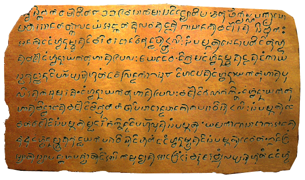
Merchants transported more than valuable commodities along the trans-Saharan routes. Just as Buddhism reached the Chinese Empire via Indian merchants traveling the Silk Road, Islam reached West Africa through Arab merchants on Saharan caravan routes. Arab merchants brought the Koran and the written language of Arabic to traditionally oral cultures in West Africa. The extensive trade networks throughout North and West Africa created a medium through which Islam spread peacefully, initially through the merchant class. By sharing a common religion and a common language (Arabic), traders showed greater willingness to trust, and therefore invest, in one another.

eating
Sharing a meal, sharing a culture.

The British Museum describes the process of conversion in West Africa:

It was Arab traders who first brought the new religion to the kingdom of Mali. Many of them were educated and religious men who through speech and the books of learned writers managed to spread the word. Malians who became traders, and who moved further from their roots, began abandoning their old religion and adopting Islam which proved a passport for entry into northern markets. Traders were followed by Arab immigrants who came as judges, imams and teachers and who settled in the country. They were treated with respect and one Mansa (king) even married his daughters to two of them. Mosques were built, and Islamic influences were felt in architecture, poetry, cooking and even dress. Men were sent to study in Moroccan madrasas (religious schools). Timbuktu became a major centre of Islamic culture and learning. Even so, in the villages much of the old religion remained, and Ibn Battuta was shocked to discover, even at court, old ceremonial dances being performed during an Islamic religious festival.

The Great Mali Empire

During the 13th and 14th centuries, the great Mali Empire owed its prosperity to its position at the center of a network of caravan trade routes which criss-crossed West Africa, linking sub-Saharan Africa, the Islamic world, and the Mediterranean. The empire was founded in 13th Century by Sundiata Keita, whose exploits remain celebrated in Mali today.

great mali map

Sundiata Keita

From the British Museum:

Sunjata (r. 1235–1255) was the first king to unify the Mandinka kingdoms and is as much a figure of legend as of fact. Epic songs of the griots tell of the ‘magician’ Sunjata who, when the Mandinka could no longer bear the burden of paying taxes to their Sosso leader Sumanguru, led them into battle. Sunjata killed Sumanguru at the Battle of Krina in 1235, and seized the major territories through which gold was traded. Sunjata declared himself Mansa (King of Kings) of the twelve kingdoms of the Mandinka. The 12 kings swore to obey Sunjata in return for being named governors of their territories. To help him rule, Sunjata set up a Gbara, or Great Assembly, of clan elders who would discuss and make decisions. Over the next two centuries the kingdom would expand through war, until it covered 1.3 million km2 . Sunjata’s successor Ali is credited with conquering the great trading centres of Timbuktu and Djenné.

An Oral History
image
A griot in modern Mali.
There are a few written accounts of this period, because West African society relied on a tradition of oral history passed down by griots (professional storytellers).  Our picture of the Mali Empire comes mainly from the modern continuation of this oral tradition, archaeological research, the extant remains of cities, and the accounts of a few visiting writers.  

In addition to royal griots who served the court, most villages also had their own griot, who told tales of births, deaths, marriages, battles, hunts, affairs, and hundreds of other things. 

Francis Bebey writes about the griot in his book African Music, A People’s Art (Lawrence Hill Books):

“The West African griot is a troubadour, the counterpart of the medieval European minstrel… The griot knows everything that is going on… He is a living archive of the people’s traditions… The virtuoso talents of the griots command universal admiration. This virtuosity is the culmination of long years of study and hard work under the tuition of a teacher who is often a father or uncle. 

griot 2

Mali’s Economy

With an economy built on the basis of the trans-Saharan trade, the Mali Empire was the largest and longest lasting kingdom in the history of West Africa. It profoundly influenced the culture of the region through the spread of its language, laws and customs along the Niger River, which ran through the heart of the empire. The empire contained three immense gold mines – Bambuk, Boure and Galam within its borders, by some estimates accounting for nearly half the gold supply in Africa, Asia, and Europe from the 12th century on. The empire taxed every ounce of gold, copper, and salt that crossed its borders.

Gold

Gold nuggets were the exclusive property of the mansa (king), and were illegal to trade within his borders. All gold was immediately handed over to the imperial treasury in return for an equal value of gold dust. Gold dust had been weighed and bagged for use at least since the reign of the Ghana Empire. Mali borrowed the practice to stem inflation of the substance, since it was so prominent in the region. The most common measure for gold within the realm was the ambiguous mithqal (4.5 grams of gold). This term was used interchangeably with dinar, though it is unclear if coined currency was used in the empire. Gold dust was used all over the empire, but was not valued equally in all regions.

gold
Panning for gold is still a common – if challenging – livelihood in some West African nations.
Slaves

Similar to Christianity of the time, Islamic Sharia law allowed slavery, but prohibited slavery involving other preexisting Muslims; as a result, the main target for slavery were the people who lived in the frontier areas of Islam in Africa, in the Sahara and Sahel. Bernard Lewis writes that “polytheists and idolaters were seen primarily as sources of slaves, to be imported into the Islamic world and molded in Islamic ways, and, since they possessed no religion of their own worth the mention, as natural recruits for Islam.”

slaves

Large numbers of Africans were sent north, generally to serve as domestic servants or slave concubines. The West African states imported highly trained slave soldiers. It has been estimated that from the 10th to the 19th century some 6,000 to 7,000 slaves were transported north each year.

Salt
salt
Rock salt at the market in Mopti. It is sold here in slabs, broken and weighed, and packaged into smaller amounts.

The next great unit of exchange in the Mali Empire was salt. Salt was as valuable, if not more valuable than gold in Sub-Saharan Africa. Salt is produced in the Sahara (and has been for over 2½ thousand years-mentioned by Herodotus) at several places. Since ancient times, salt has been used to flavor and preserve food. Salt was either extracted from evaporating pools or mined from underground, left behind from dried up ancient seabeds. It was cut into pieces and spent on goods with close to equal buying power throughout the empire. While it was as good as gold in the north, it was even better in the south. Salt was relatively rare in the south. The northern region on the other hand had no shortage of salt. Every year merchants entered Mali via Oualata with camel loads of salt to sell in Niani. According to Ibn Battuta who visited Mali in the mid-14th century, one camel load of salt sold at the northern trading post of Walata for 8–10 mithkals of gold, but in Mali proper it was worth 20–30 ducats and sometimes even 40. One particular source of salt in the Mali empire were salt-mining sites located in Taghaza. Ibn Battuta wrote that in Taghaza there were no trees and there is only sand and the salt mines. Nobody lived in the area except the Musafa slaves who working to dug the salts and lived on imported dates, camel meat, and millet imported from the Sudan. The buildings were even constructed from slabs of salt and roofed with camel skins. The salt was dug from the ground and cut into thick slabs, two of which were loaded onto each camel where they will be taken south across the desert and sold.

salt 2
Salt, mined from large deposits, is loaded onto boats on the Niger River.

No government can rule a nation if there is no economic activity to feed the people. Moroccan cities such as Fez and Marrakech appear to be landlocked on any map – they are nowhere near the ocean.  But in a very real sense, they are ports on the edge of a great sea – the Sahara.  Along with their neighbors to the south in Mali, the Berbers of Morocco became sailors on that sea, moving goods in great caravans on the backs of camels. Control of the last leg of the Saharan trade routes fueled the rise of Moroccan dynasties such as the Almoravids and Almohads.  The people of Morocco have long benefitted from their unique geographic perch – building an enterprising and resourceful civilization based on trade that straddles the Mediterranean and sub-Saharan worlds.


THIS LESSON WAS MADE POSSIBLE THROUGH A GENEROUS GRANT FROM THE QATAR FOUNDATION.

The article was adapted in part from:

  1. Tran-Saharan Trade
  2. The Camel
  3. The Kingdom of Mali

Islands in a Friendly Sea: Some Basics of Filipino History and Culture

This lesson was reported from:
Adapted in part from open sources.

Balangays and Barangays

  1. What is a balangay? 
  2. What is a barangay?

Image result for balangay
A balangay is traditional Filipino ship, made of wooden planks and pins.  It is used for everything from fishing to hauling cargo, travel and conducting war, and it was likely the boat that carried the original settlers of the Philippines to the islands in ancient times.

The balangay is a boat used by native Filipinos for at least 2,000 years.  The balangay could cross open ocean – with navigation techniques involving the sun, the stars, the wind, cloud formations, wave patterns, and bird migrations.  The word barangay – a variant – is also the word used to describe the basic unit of Filipino political organization, with a meaning similar to clan, before the arrival of the Spanish.  Members of a barangay – typically 30 to 100 families – owed their allegiance to a datu, or chief, who ruled in conjunction with other datus.  So, poetically you could think of your community as the people who were in the same boat as you.

While this system fell away under Spanish rule, the word barangay is still used to describe a neighborhood in the Philippines, an evocative double meaning in a nation so oriented to the sea.

There are a number of distinctions between the modern barangay or Barrio, and the city-states and independent principalities encountered by the Spanish when they first arrived in 1521 and established relatively permanent settlements in 1574. The most glaring difference would be that the modern entity represents a geographical entity, the pre-colonial barangays represented loyalty to a particular head (datu). Even during the early days of Spanish rule, it was not unusual for people living beside each other to actually belong to different barangays.

The barangay of precolonial times was either independent, or belonged to what was only a loose confederation of several barangays, over which the rulers picked among themselves who would be foremost – known as the Pangulo or Rajah. In most cases, his function was to make decisions which would involve multiple barangays, such as disputes between members of two different barangays. Internally, each datu retained his jurisdiction.

Image result for barangay
The barangay hall is typically a combination of city hall and community center.

timelineWho are the Filipinos?

  1. Consider the map of the Philippines – how does the country’s unique geography lend itself to the diversity of its population?

Image result for philippines gold chain ayala
This ten pound pure gold halter is one of the most spectacular artifacts ever found in the Philippines.  It is believed by some to be an Upavita, a ceremonial sacred thread worn members of the Brahmin class of India after a purification ritual – its existence demonstrates the influence of Hinduism and Indian culture in the early Philippines. (Ayala Museum, Makati, Philippines, 2018.)

There is no easy way to describe Filipino culture – no one settled definition – because the Philippines are a particularly diverse nation spread across some 7,000 islands, with hundreds of distinct languages and dialects, thousands of years worth of history, trade, and colonization serving to add color and flavor to what seems like a simple question.

Prior to the advent of European colonialism in the 1500s CE, much Southeast Asia including the Philippines was under the influence of greater India.  India was a wealthy society with well-developed technology and religions.  Indians spread throughout southeast Asia as professionals, traders, priests and warriors, bringing with them a written language (Sanskrit) and religion (Hinduism or Buddhism).


Image result for philippines gold chain ayala
Detail of the sacred thread, woven entirely from gold.

Numerous Indianized principalities and empires flourished for centuries in areas that would become modern Thailand, Indonesia, Malaysia, Singapore, Philippines, Cambodia and Vietnam.  Artwork, philosophy, models for royalty and class structure, as well as written languages in these lands were all influenced by India, similar to the way that Greek culture was a guiding influence on later European societies.  However, each of these countries adapted, blended, and assimilated this Indian influence in its own unique way, giving rise to the great diversity of cultures seen even just in the islands that make up the modern Philippines.

Locations of pre-colonial Polities and Kingdoms.
Locations of pre-colonial Filipino Polities and Kingdoms (900 CE to 1565 CE).

By 1000 BCE, the inhabitants of the Philippine archipelago had developed into four distinct kinds of peoples: tribal groups, such as the AetasHanunooIlongots and the Mangyan who depended on hunter-gathering and were concentrated in forests; warrior societies, such as the Isneg and Kalinga who practiced social ranking and ritualized warfare and roamed the plains; the petty plutocracy of the Ifugao Cordillera Highlanders, who occupied the mountain ranges of Luzon; and the harbor principalities of the estuarine civilizations that grew along rivers and seashores while participating in trans-island maritime trade. It was also during the first millennium BC that early metallurgy was said to have reached the archipelagos of maritime Southeast Asia via trade with India.

Piloncitos, small bead-like gold bits, each about the size of a corn kernel, are considered to be the earliest coin used for trade starting around the 9th Century CE by ancient Filipinos.  This one is marked with Baybayin, and a prehispanic Filipino alphabet.

Around 300–700 CE, the seafaring peoples of the islands traveling in balangays began to trade with the Indianized kingdoms in the Malay Archipelago and the nearby East Asian principalities, adopting influences from both Buddhism and Hinduism.

The Boxer Codex

  1. What is the Boxer Codex, and what can it tell us about the Philippines?
  2. Describe the general social structure of the prehispanic Philippines.  In what ways is it similar to or different from the social structure in your own society?
  3. Consider your status in your own society – to which corresponding class would you belong in ancient Filipino society?  Justify your answer.  Is this different from the class you WISH you belonged to?
  4. Can identify any foreign influence assimilated into the social structure of the Filipinos?

Image result for boxer codex
An illustration from the Boxer Codex depicting a Spanish ship greeted by natives of the Mariana Islands, near the Philippines, naked and seemingly bearing gifts.  The Boxer Codex is one of the earliest attempts to describe Filipino daily life in detail.

The Philippines were ruled as a colony of Spain for 333 years.  This colonial experience transformed the culture and social structure of the islands dramatically, as Spaniards converted Filipinos to Christianity, reorganized barangays into barrios that suited Spanish political needs, and reorganized farming and land use according to their own economic needs.  The diverse languages and traditions of prehispanic Filipinos did not disappear completely, by any means, and much can be learned by talking to and studying the way of life practiced in various parts of the modern Philippines.

However, another important way that historians and anthropologists can gain greater insight into what the Philippines were like before the Spanish arrived is via the Boxer Codex, an illustrated manuscript commissioned by the Spanish around 1590.  The Boxer Codex depicts the TagalogsVisayansZambals, Cagayanes or possibly Ibanags and Negritos of the Philippines in vivid color.  The technique of the paintings, as well as the use of Chinese paper, ink, and paints, suggests that the unknown artist may have been Chinese.  Since Spanish colonial governors were required to submit written reports on the territories they governed, it is likely that the manuscript was written under the orders of the governor.  While it is written from an outsider’s perspective and contains many cultural biases that the Spanish carried with them, it is still an invaluable tool: this richly illustrated document provides a window into Filipino society at a time when the Spanish themselves were trying to gain a clear picture of it.

Social Hierarchy of Pre-colonial Polities


Class Title Description
Maginoo (Ruling Class)
RajaLakan,
Paramount Leader of the confederacy of barangay states. In a confederacy forged by alliances among polities, the datu would convene to choose a paramount chief from among themselves; their communal decision would be based on a datu’s prowess in battle, leadership, and network of allegiances.
Boxer codex.jpg 
Datu
Datus were maginoo with personal followings (dulohan or barangay). His responsibilities included: governing his people, leading them in war, protecting them from enemies and settling disputes. He received agricultural produce and services from his people, and distributed irrigated land among his barangay with a right of usufruct.
Visayans 3.png
Maginoo
Maginoo comprised the ruling class of Tagalogs. Ginoo was both honorific for both men and women.Panginoon were maginoo with many slaves and other valuable property like houses and boats . Lineage was emphasized over wealth; the nouveau riche were derogatorily referred to as maygintawo (fellow with a lot of riches).

Members included: those who could claim noble lineage, members of the datu’s family.

Sultan Powerful governor of a province within the caliphate or dynasties of Islamic regions. Their position was inherited by a direct descent in a royal bloodline who could claim the allegiances of the datu. Sultans took on foreign relations with other states, and could declare war or allow subordinate datus to declare war if need be. The sultan had his court, a prime minister (gugu), an heir to the throne (Rajah Muda or crown prince), a third-ranking dignitary (Rajah Laut, or sea lord) and advisers (pandita).
Timawa and Maharlika (Middle Class and Freemen Visayans 2.png
Timawa
The timawa class were free commoners of Luzon and the Visayas who could own their own land and who did not have to pay a regular tribute to a maginoo, though they would, from time to time, be obliged to work on a datu’s land and help in community projects and events. They were free to change their allegiance to another datu if they married into another community or if they decided to move.

In Luzon, their main responsibility to the datu was agricultural labor, but they could also work in fisheries, accompany expeditions, and row boats. They could also perform irregular services, like support feasts or build houses

In Visayas, they paid no tribute and rendered no agricultural labor. They were seafaring warriors who bound themselves to a datu.

Members included: illegitimate children of maginoo and slaves and former alipin who paid off their debts

Cagayan Warrior.png 
Maharlika
Members of the Tagalog warrior class known as maharlika had the same rights and responsibilities as the timawa, but in times of war they were bound to serve their datu in battle. They had to arm themselves at their own expense, but they did get to keep the loot they won – or stole, depending on which side of the transaction you want to look at. Although they were partly related to the nobility, the maharlikas were technically less free than the timawas because they could not leave a datu’s service without first hosting a large public feast and paying the datu between 6 and 18 pesos in gold – a large sum in those days.
Naturales 1.png 
Alipin/Uripon (Slaves)
Alipin Namamahay Today, the word alipin means slave and that’s how the Spaniards translated it, too, but the alipins were not really slaves in the Western sense of the word. They were not bought and sold in markets with chains around their necks. A better description would be to call them debtors.  Slaves who lived in their own houses apart from their creditor. If the alipin’s debt came from insolvency or legal action, the alipin and his debtor agreed on a period of indenture and an equivalent monetary value in exchange for it. The alipin namamahay was allowed to farm a portion of barangay land, but he was required to provide a measure of threshed rice or a jar of rice wine for his master’s feasts. He came whenever his master called to harvest crops, build houses, row boats, or carry cargo.Members included: those who have inherited debts from namamahay parents, timawa who went into debt, and former alipin saguiguilid who married.
Alipin Saguiguilid Slaves who lived in their creditor’s house and were entirely dependent on him for food and shelter. Male alipin sagigilid who married were often raised to namamahay status, because it was more economical for his master (as opposed to supporting him and his new family under the same roof). However, female alipin sagigilid were rarely permitted to marry.Members included: children born in debtor’s house and children of parents who were too poor to raise them.

The Laguna Copperplate

  1. What is the Laguna Copperplate?  How does it further illuminate our understanding of early Filipino social structure?
  2. Do you have documents that perform similar functions in your own society?  What are they?
The Laguna Copperplate, a legal document inscribed on a copper plate in 900 AD, is the earliest known written document found in the Philippines.  The document states that it releases its bearers, the children of Namwaran, from a debt in gold amounting to 1 kati and 8 suwarnas (865 grams; 27.8 troy ounces).

The Laguna Copperplate Inscription was found in 1989 near the mouth of the Lumbang River near Laguna de Bay, by a man who was dredging sand to turn into concrete. Suspecting that the artifact might have some value, the man sold it to an antique dealer who, having found no buyers, eventually sold it to the National Museum of the Philippines, where it was assigned to Alfredo E. Evangelista, head of its anthropology department.

The text reads:

Line Transliteration Original translation by Antoon Postma (1991) Notes
1 swasti shaka warshatita 822 waisakha masa ding jyotishachaturthikrishnapaksha so- Hail! In the Saka-year 822; the month of March–April; according to the astronomer: the fourth day of the dark half of the moon; on
2 -mawara sana tatkala dayang angkatan lawan dengannya sanak barngaran si bukah Monday. At that time, Lady Angkatan together with her relative, Bukah by name,
3 anakda dang hwan namwaran di bari waradana wi shuddhapat(t)ra ulih sang pamegat senapati di tundu- the child of His Honor Namwaran, was given, as a special favor, a document of full acquittal, by the Chief and Commander of Tundun
4 n barja(di) dang hwan nayaka tuhan pailah jayadewa. di krama dang hwan namwaran dengan dang kaya- representing the Leader of Pailah, Jayadewa. This means that His Honor Namwran, through the Honorable Scribe
5 stha shuddha nu di parlappas hutangda wale(da)nda kati 1 suwarna 8 di hadapan dang hwan nayaka tuhan pu- was totally cleared of a salary-related debt of 1 kati and 8 suwarna (weight of gold): in the presence of His Honor the Leader of Puliran,
6 liran ka sumuran. dang hwan nayaka tuhan pailah barjadi ganashakti. dang hwan nayaka tu- Kasumuran; His Honor the Leader of Pailah, representing Ganasakti; (and) His Honor the Leader
7 han binwangan barjadi bishruta tathapi sadanda sanak kaparawis ulih sang pamegat de- of Binwangan, representing Bisruta. And, with his whole family, on orders of the Chief of Dewata
8 wata [ba]rjadi sang pamegat medang dari bhaktinda di parhulun sang pamegat. ya makanya sadanya anak representing the Chief of Mdang, because of his loyalty as a subject (slave?) of the Chief, therefore all the descendants
9 chuchu dang hwan namwaran shuddha ya kaparawis di hutangda dang hwan namwaran di sang pamegat dewata. ini gerang of his Honor Namwaran have been cleared of the whole debt that His Honor owed the Chief of Dewata. This (document) is (issued) in case
10 syat syapanta ha pashchat ding ari kamudyan ada gerang urang barujara welung lappas hutangda dang hwa … there is someone, whosoever, some time in the future, who will state that the debt is not yet acquitted of His Honor… * Line 10 of the LCI ends mid-sentence.

A year later, linguist Antoon Postma noted that the inscription was similar to the ancient Indonesian script of Kawi. Postma translated the script and found the document dated itself to the Saka year 822, an old Hindu calendar date which corresponds to 900 AD, making the Laguna Copperplate the earliest example of writing ever found in the Philippines. The document pre-dated the arrival of Ferdinand Magellan in 1521 and is from about the same time as the mention of the first known mention of Philippines in world history, in the official Chinese Song dynasty History of Song for the year 972.

Image result for laguna copperplate inscription
Place names mentioned in the Laguna Copperplate Inscription.

The text of the Laguna Copperplate offers us a window into Tondo culture, an ancient Filipino barangay that thrived along the Pasig River, not far from modern Metro Manila.  Because it is written in Kawi, an Indonesian script, and uses several Sanskrit loan-words, it demonstrates just how connected the Philippines were with other ancient societies in Southeast Asia.

IMG_2018
A turo turo is a special kind of Filipino restaurant.  Food is prepared in advance, and customers point, point – turo, turo in Tagalog – to the dishes they want to order. In a turo turo, one can find many of the Philippines’ most popular foods – and a great primer on its history. (Pasig City, Philippines, 2018.)

Available in the turo turo: Adobo is a popular dish in Philippine cuisine that usually involves pork or chicken marinated in vinegar, soy sauce, garlic, and black peppercorns. It has sometimes been considered as the unofficial national dish in the Philippines. Early Filipinos often cooked by immersion in vinegar and salt to preserve the food longer in the island heat.

New Voices, New Flavors

  1. What outside cultures have contributed to the notion of what a Filipino is?  Describe ways in which these newcomers have shaped the Philippines.

Trade and interactions with China have also shaped the culture of the Philippines since ancient times.  Starting in the 900s CE, trade with China become more regular, leading to increased access to Chinese goods as well as intermarriage between Chinese merchants and local Filipino women.  This exchange would culminate in the Manila galleon route during the Spanish colonial period. The arrival of the Spaniards to the Philippines attracted new waves of immigrants from China, and maritime trade flourished during the Spanish period. The Spanish recruited thousands of Chinese migrant workers called sangleys to build the colonial infrastructure in the islands. Many Chinese immigrants converted to Christianity, intermarried with the locals, and adopted Hispanized names and customs and became assimilated.

Image result for lumpia
Available in the turo turo: Lumpia are made from meat and vegetables, rolled in a crepe-like shell and usually fried.  They were brought to the Philippines by merchants from China’s Fujian province and have become a favorite Filipino snack.

Trade brought Arab and Malay merchants to the Philippines, especially in the southern islands of Mindanao and Palawan.  These traders brought with them their religion – Islam, which continues to be a crucial part of Filipino identity in these islands, where as much as 10% of the population is Muslim.  In fact, it is possible that if the Spanish had arrived much later, Islam could have become the dominant religion of the Philippines; while the independent-minded barangays were conquered one by one by the Spanish, the Muslim sultanates of that existed upon their arrival were united by a cohesive religious identity that contributed to an increased ability to resist Spanish attempts to dominate these islands.

philippinearab
Arab traders have been visiting Philippines for nearly 2000 years. After the advent of Islam, in 1380, Karim ul’ Makhdum, the first Muslim missionary to reach the Sulu Archipelago, brought Islam to what is now the Philippines, first arriving in Jolo. Subsequent visits of Arab Muslim missionaries strengthened the Muslim faith in the Philippines, concentrating in the south and reaching as far north as Manila. (Diorama in the Ayala Museum, Makati, Philippines, 2018.)

Image result for philippine satti
Available in the turo, turo: Satti is skewered, barbecued meat carried throughout the islands of Southeast Asia by Muslim traders.

The arrival of Portuguese explorer Ferdinand Magellan in 1521 began a period of European colonization. During the period of Spanish colonialism the Philippines was part of the Viceroyalty of New Spain, which was governed and controlled from Mexico City. Early Spanish settlers were mostly explorers, soldiers, government officials and religious missionaries born in Spain and Mexico who worked to convert the Philippines into a country that is today 83% Catholic.

2018-06-12 16.33.37
The death of Ferdinand Magellan while engaged in combat with the warriors of Lapu-Lapu became a potent symbol for later Filipino nationalists chaffing under the rule of the Spanish. (Diorama in the Ayala Museum, Makati, Philippines, 2018.)

A lush carving depicting the Virgin Mary – an important symbol for Filipino Catholics – adorns the 400 year old door of San Agustin Church.  The first San Agustin Church was the first religious structure constructed by the Spaniards on the island of Luzon. Made of bamboo and nipa, it was completed in 1571, but destroyed by fire in December 1574 during the attempted invasion of Manila by the forces of the Chinese pirate Limahong. A second wooden structure built on the same site. was destroyed in February 1583, by a fire that started when a candle ignited drapery on the funeral bier during services for Spanish Governor-General Gonzalo Ronquillo de Peñalosa.  The Spanish rebuilt the church using stone beginning in 1586. (Intramuros, Manila, Philippines, 2018.)

The Peninsulares (governors born in Spain), mostly of Castilian ancestry, settled in the islands to govern their territory. Most settlers married the daughters of rajahsdatus and sultans to reinforce the colonization of the islands. The Ginoo and Maharlika castes (royals and nobles) in the Philippines prior to the arrival of the Spanish formed the privileged Principalía (nobility) during the Spanish period.

Image result for longganisa
Available in the turo turo: Longganisa is a (usually, but not always) sweet sausage of Spanish origin eaten widely across the Philippines, with lots of varieties suited to local tastes across difference islands.  Here, it is served with eggs and rice for breakfast, but it be eaten at any meal.  In addition, as part of the Colombian Exchange, Spanish colonizers brought with them produce from the Americas like chili peppers, tomatoes, corn, potatoes, and the method of sautéing with garlic and onions.

Introduced from Spain, Lechón is a whole roasted pig, prepared throughout the year for any special occasion, during festivals, and the holidays. After seasoning, the pig is cooked by skewering the entire animal, entrails removed, on a large rotisserie stick and cooking for several hours in a pit filled with charcoal. The process of cooking and basting usually results in making the pork skin crisp and is a distinctive feature of the dish.

In modern times, the Philippines was an American colony and protectorate, meaning that English became the language of business and education, and the economy and culture of the Philippines was influenced heavily by this interaction.

The jeepney is the most popular form of public transportation in the Philippines and a relic of U.S. occupation.  Surplus Jeeps left behind by the U.S. military upon Philippine independence were transformed – their bodies were extended to increase passenger capacity and decorated in vibrant colors with chrome-plated ornaments on the sides and hood.  Thus was born a unique form of Filipino transportation. (Pasig City, Philippines, 2018.)

Image result for jollibee
Not available in the turo turo: The Americans inspired an abiding love of fried chicken and a distinctive, sweet style of spaghetti.  While you might be able to get each of those at the turo turo, Jollibee is a homegrown Filipino fast food restaurant with more locations across the country than McDonalds – they seem to have the market cornered.


Activities

  1. Seek out some Filipino recipes.  There are also plenty of cooking tutorial videos online.  Visit an Asian grocery store, purchase the necessary ingredients, and actually make a Filipino dish for dinner.  And don’t forget dessert – halo halo is one of my favorites (only the Filipinos would think to put raw beans in an icy desert).
  2. There is a long tradition of resistance to colonial rule in the Philippines. 

    Juan Sumuory is celebrated in the Gallery of Heroes. (Manila, Philippines, 2018.)

    Couple of this with the country’s strong Catholicism – with its tradition of sainthood and martyrdom – and you have nation that is very aware of those who have sacrificed to advance the cause of the Filipino.  Manila’s Rizal Park features the Gallery of Heroes, a row of bust sculpture monuments of historical Philippine heroes.  These include:  Andres Bonifacio, Juan Sumuroy, Aman Dangat, Marcelo H. Del Pilar, Gregorio Aglipay, Sultan Kudarat,  Juan Luna, Melchora Aquino, Rajah Sulayman, and Gabriela Silang.  Choose one of these personalities to commemorate in your own classroom.  Write a brief description of their accomplishments to accompany a piece of artwork that celebrates their life for those who aren’t aware.

FURTHER READING

History of the Philippines: From Indios Bravos to Filipinos by Luis Francia.


Today, the Philippines is increasingly urbanized.  Manila, the capital, is one of the most densely populated cities on the planet. (Manila, Philippines, 2018.)


THIS LESSON WAS INDEPENDENTLY FINANCED BY OPENENDEDSOCIALSTUDIES.ORG.

If you value the free resources we offer, please consider making a modest contribution to keep this site going and growing.

The Dubai Mall, Sharia Law, and Social Norms: No Short-Shorts, No PDA

This lesson was reported from:

Continue reading “The Dubai Mall, Sharia Law, and Social Norms: No Short-Shorts, No PDA”

New Mini-Documentary: What Happens in a Mosque?

Our new Open Ended Social Studies video has gone live.  Use it in your classroom to supplement your lessons on Islam.  Kick start a conversation about salat and the Five Pillars.  Answer the question: What happens in a mosque?

LESSON PLANS

Continue reading “New Mini-Documentary: What Happens in a Mosque?”

Muhammad, the Prophet of Islam

Who was Muhammad, and how did the Arab world of the seventh century shape his teachings? Continue reading “Muhammad, the Prophet of Islam”

November 22, 2016: Haram in Qatar, or How I Learned Not to Cast the First Stone

According to The Qatar Tribune, Qatari customs officials destroyed some 31,000 bottles of wine seized after routine inspections of incoming shipping containers in the nation’s port. Continue reading “November 22, 2016: Haram in Qatar, or How I Learned Not to Cast the First Stone”

November 19, 2016: Grand Mosques and Grand Desert Adventure in Abu Dhabi

The Sheikh Zayed Grand Mosque is located in Abu Dhabi, and is the largest mosque in the United Arab Emirates.  It holds up to 40,000 worshippers, has four massive minarets, each 106 meters tall with designs incorporating elements from major periods in Islamic history, and 82 domes, each inscribed in gold with verses from the Holy Quran.   Continue reading “November 19, 2016: Grand Mosques and Grand Desert Adventure in Abu Dhabi”