A Basic History of Morocco (Free online text suited for middle or high school classroom use, guided reading questions, and suggested activities): A brief overview of the geography, culture, and history of Morocco.
The Berbers: A Free and Noble People (Free online text suited for middle or high school classroom use, guided reading questions, and suggested activities): Who are the Berber, and what makes them a distinct and special people?
The Sahara, Camel, and the Caravan Trade (Free online text suited for middle or high school classroom use, guided reading questions, and suggested activities): Highlighting the role of the caravan trade in Morocco’s ancient economy. That trade was made possible in large part by the camel, which allowed Berber, Arab, and sub-Saharan peoples to traverse the harsh Sahara desert, moving trade goods, and establishing religious and cultural connections where none could otherwise exist.
Fes: Center of Moroccan Empire and Culture (Free online text suited for middle or high school classroom use, guided reading questions, and suggested activities): The first capital of a united Morocco has been a dynamic player in culture, education, and the economy of North Africa for more than a thousand years.
The Medina: Sustainable Cities of the Ancient World (Free online text suited for middle or high school classroom use, guided reading questions, and suggested activities): Examining the characteristics of a traditional medina, and evaluating those traits as a possible template for a more walkable, communal, sustainable future.
Chefchaouen and the Moroccan Quest for Independence (Free online text suited for middle or high school classroom use, guided reading questions, and suggested activities): Exploring Morocco’s experiences as an imperial power – and as the subject of imperial power from abroad. This history has shaped a distinctive culture at the crossroads of the Mediterranean, European, and African worlds.
Background on Islam, the dominant religion in Morocco:
Muhammad, the Prophet of Islam (Free online text suited for middle or high school classroom use, guided reading questions, and suggested activities): Who was Muhammad, and how did the Arab world of the seventh century shape his teachings?
Five Pillars to Hold Me Up: What Do Muslims Believe? (Free online text suited for middle or high school classroom use, guided reading questions, and suggested activities):What are the basic teachings of Islam, and what does it mean to be a Muslim?
Who are the Berber? Briefly describe their culture.
What do Berbers call themselves, and what does it mean in English?
Write your name in the Berber alphabet.
An anthropologist is someone who examines culture, artifacts, religion, language, lifestyles, and traditions to describe and understand a group of people, either from the present or the past. How would an anthropologist describe your community’s culture and history?
The main ethnic group inhabiting the Maghreb – which literally means “the west” in Arabic, and includes Morocco, Algeria, and Tunisia – are known as the Berber people. They and their ancestors have inhabited North Africa for more than 10,000 years, and possess a rich history and culture shaped by the varied geography of the area, as well as by their interactions with other groups, including the Phoenicians, the Romans, the Arabs, the Spanish, and the French.
The Berbers call themselves Imazighen, which means free or noble people in their own language. It is a fitting descriptor.
Historically, the Berbers have been successful in trade, navigating the harsh conditions of the Sahara and the Atlas Mountains, linking Sub Saharan Africa to the Mediterranean world when other groups struggled to do so. In ancient times, this wealth – as well as Berber prowess on horseback meant that groups such as the Carthaginians were paying them tribute in North Africa.
Unlike the conquests of previous religions and cultures, the coming of Islam, which was spread by Arabs, was to have extensive and long-lasting effects on the Maghreb. The new faith, in its various forms, would penetrate nearly all segments of Berber society, bringing with it armies, learned men, and fervent mystics, and in large part replacing tribal practices and loyalties with new social norms and political traditions influenced by the Arab world.
The Almohad Empire, a Berber empire based in Morocco that lasted from 1121 to 1269.
Traditionally, Berber men take care of livestock such as sheep, goats, cows, horses, and camels. Families migrate by following the natural cycle of grazing, and seeking water and shelter with the changing seasons. They are thus assured with an abundance of wool, cotton, and plants used for dyeing. For their part, women look after the family and produce handicrafts like clothing, rugs, or blankets – first for their personal use, and secondly for sale in local souqs, or markets. While many Berber still live according to these patterns, many more no longer follow these traditional patterns – they now have jobs, homes, and lifestyles similar to any of those found in your country.
The Berber are experts of irrigation, drawing water from mountain rivers and feeding it via gravity into green oases of productivity.
Traditionally, Berber men have raised livestock like these sheep, which provide wool, meat, and leather.
The goats are nearly as resourceful as the Berber themselves.
Staple crops of the modern Berber are wheat, corn, dates, and tomato.
The Berber inhabit a wide range of climate zones, including this harsh foothills of the Atlas Mountains, on the edge of the Sahara Desert. Rainfall and grass are sparse here, and the hearty goats herded by the Berber graze in the Argon trees that thrive in this arid landscape.
Berber women have traditionally created inticateky woven patterns on looms such as this one.
Berber women hand stitch the lushly detailed patterns seen on these kaftans. The work is exacting – and can earn a good income for the skilled artisan.
The Berber also cultivate alfalfa as a feed for livestock. This alfalfa is cut, bundled, and carried home from a family garden plot, usually by women.
Other Berber men work in tanneries, turning animal hides into leather in these vats of ammonia. The ammonia is sourced from the waste of animals.
Increasingly, the Berber are sedentary, but traditionally, many have been nomadic, following the green grass with their herds on a seasonal basis. This is mobile home of one family who still follows such a nomadic existence.
Like kids almost anywhere, modern Berber children love to play soccer – anywhere, any time.
Some Berber men create impressive tiled mosaics. These are the plain backsides of vibrantly-colored tiles, which will be held together with concrete. When flipped over, they will create a stunning geometric pattern – avoiding the depiction of the human form, as prescribed by Islam.
The traditional social structure of the Berbers is tribal. A leader is appointed to command the tribe through a generally democratic process. In the Middle Ages, many women had the power to govern. The majority of Berber tribes currently have men as heads of the tribe.
Berber hospitality centers on a sweet mint tea, offered upon the arrival of guests. Refusal of this offer is considered to be quite rude – take the tea! Let it cool! Have a sip!The Berber are known for creating beautiful, artist front doors for their homes, featuring striking patterns, carvings, metal work, and sometimes bright colors.
Imazighen (Berber) cuisine draws influence and flavors from distinct regions across North Africa and the Mediterranean world.
Principal Berber foods include:
Couscous, a staple dish made from a grain called semolina
Tajine, a stew made in various forms
Pastilla, a meat pie traditionally made with squab (fledgling pigeon) often today using chicken
Morocco is a former French colony, and French-style cafe culture has also influenced the country. Men in particular can be found at most hours of the day drinking espresso or tea, and possibly eating a pastry in one of the country’s thousands of cafes.
A tajine (Standard Moroccan Berber: ⵜⴰⵊⵉⵏ) is a Maghrebi dish which is named after the earthenware pot in which it is cooked. The earliest writings about the concept of cooking in a tajine appear in the famous One Thousand and One Nights, though the dish would have been already famous amongst the nomadic Bedouin people of the Arabian Peninsula, who added dried fruits like dates, apricots and plums to meat like mutton, chicken, or camel, giving tajine its unique taste. Tagine is now often eaten with french fries, either on the top or on the side.
Couscous (Berber : ⵙⴽⵙⵓ seksu, Arabic: كُسْكُس kuskus) is originally a Maghrebi dish of small (about 3 millimetres (0.12 in) diameter) steamed balls of crushed durum wheat semolina that is traditionally served with a stew spooned on top. It is a staple of the Moroccan diet, meaning that is eaten routinely and in such quantities that it constitutes a dominant portion of a standard diet for a given people, supplying a large fraction of energy needs and generally forming a significant proportion of the intake of other nutrients as well. In Tunisia, Algeria, Morocco, and Libya, couscous is generally served with vegetables (carrots, potatoes, and turnips) cooked in a spicy or mild broth or stew, and some meat (generally, chicken, lamb or mutton).
Pastilla (Moroccan Arabic: بسطيلة, romanized: bəsṭila) is a traditional Moroccan dish of Andalusian origin consumed in countries of the Maghreb. It is a pie which combines sweet and salty flavours; a combination of crisp layers of the crêpe-like werqa dough (a thinner cousin of phyllo dough), savory meat slow-cooked in broth and spices and then shredded, and a crunchy layer of toasted and ground almonds, cinnamon, and sugar. Pastilla is said to be “uniquely Moroccan, intricate and grand, fabulously rich and fantastical.”
In Morocco, Tunisia, Libya, Saudi Arabia, Jordan, and other parts of the Middle East, prickly pears of the yellow and orange varieties are grown by the side of farms, beside railway tracks and other otherwise noncultivable land. It is sold in summer by street vendors, and is considered a refreshing fruit for that season.
Writing in 1377, the scholar Ibn Khaldun offered a general description of the Berber that applies nearly as well in the twenty-first century:
“As for [their] moral virtues, one can cite: respect for one’s neighbours; the protection of guests; the observance of obligations and commitments; faithful adherence to promises and treaties; resolve in misfortune; indulgence towards the failings of others; renouncement of vengeance; kindness to the unfortunate; respect for the elderly; veneration for men of science; hatred of oppression; resolve before states; determination to win in matters of power; devotion to God in matters of religion.”
Indeed, nearly eight hundred years later the anthropologist Ahmed Skounti echoed these sentiments:
“The Imazighen (singular Amazigh) also known as the Berbers are among the original peoples of North Africa. Their myths, legends and history span 9,000 years, back to the Proto-Mediterraneans. They have achieved unity by keeping up their unique language and culture which are, like their land, both African and Mediterranean.
The Berbers of Morocco share this duality, reflecting the diversity of their nature and stormy history. Through contact with other peoples of the Mediterranean, they created kingdoms but also vast territories organised into powerful, democratic, war-mongering, tribal communities. Both aspects of this social political organisation have left a mark on recent historical events and the two millenia of the country’s history. As opposed to the pagan Mediterranean kingdoms of Antiquity, Berber empires developed inland and were Muslim. Judaism continued to be practiced, and the Sunni Islam majority gradually took
on a Berber hue with its brotherhoods, zaouias, marabouts. and rituals.
The roots of the Berber culture go deep down into Morocco’s proto-history. They are illustrated by a strong link with their land, a sense of community, hospitality sharing food and a specific relationship with spirituality. Its openness to many influences whether Mediterranean, African, Oriental, European or international have defined its current characteristics.
The Berber language, an Afro-Asian idiom, is the melting pot of the history and culture of the country. It has outlived most languages of Antiquity such as Ancient Greek, Phoenician, Latin and Egyptian. It used to be written but is now mainly oral. Though there are fewer now that can speak it, the language is nevertheless still used by a substantial number of Moroccans.”
The hamsa (Berber: ⵜⴰⴼⵓⵙⵜ tafust) is a palm-shaped amulet popular throughout the Middle East and North Africa and commonly used in jewelry and wall hangings. Depicting the open right hand, an image recognized and used as a sign of protection in many times throughout history, the hamsa is believed by some, predominantly Muslims and Jews, to provide defense against the evil eye. It has been theorized that its origins lie in Ancient Egypt or Carthage (modern-day Tunisia) and may have been associated with the Goddess Tanit. The Hamsa is also known as the Hand of Fatima after the daughter of the prophet Muhammad.
The Berber are known for their skills in working with silver. Its color is associated with purity and piety. The vibrant colors that highlight the silver are called enamel, which is a technique that probably arrived in Morocco in the 1400s, as many Muslims and Jews were expelled from Christian Spain.
Inseparable from poetry and associated with the dance, Amazigh music take many forms, but two popular folk forms include Ahwach and Rouaiss. – AHWACH: is a collective dance according to musical rhythms and with a accompaniment of songs. The group composed of flatists (aouad), percussion flat drums (bendir), percussion sionists of metal instruments (naqos) and dancers. ROUAISS a musical group that sings Amazigh poetry (amerg). The instruments used are the three-stringed lute (guembri), the monochord violin (rebab), the flat drum (bendir) and an instrument percussion metal (naqoss).
If men cover their heads, it is often with a wrapping as seen in this photo, which shields their heads and faces from the heat of the sun and the any sand on the wind.
Two men in traditional Berber clothing. The long tunic worn by both men and women is called a kaftan.
The djellaba is a long, loose-fitting outer robe with full sleeves that is worn in the Maghreb region of North Africa. Djellabas are made of wool in different shapes and colors, but lightweight cotton djellabas have now become popular. Among the Berbers, or Imazighen, such as the Imilchil in the Atlas Mountains, the color of a djellaba traditionally indicates the marital status (single or married) of the bearer: a dark brown djellaba indicating bachelorhood. Almost all djellabas of both styles (male or female) include a baggy hood called a qob (Arabic: قب) that comes to a point at the back. The hood is important for both sexes, as it protects the wearer from the sun, and in earlier times, it was used as a defence against sand being blown into the wearer’s face by strong desert winds. In colder climes, as in the mountains of Morocco and Algeria, it also serves the same function as a winter hat, preventing heat loss through the head and protecting the face from snow and rain. It is common for the roomy hood to be used as a pocket during times of warm weather; it can fit loaves of bread or bags of groceries.
Many women cover their heads in accordance with Muslim tradition, but many more do not.
No matter how traditional the dress, Berbers are not stuck in the past – this man carries a messenger bag containing his cell phone and other modern necessities.
Berber Writing
French and Arabic are the dominant languages for many Berber today, as evinced by this street art in Essaouira, Morocco, but Berbers also have their own traditional language that is distinct from either.The Berber alphabet has ancient roots. It is more properly called tifinagh.
The unique Berber alphabet is called tifinagh. Like the Berbers themselves, the writing has been attributed in turn to having Egyptian, Greek, Phoeno-Punic or South-Arabic origins, though none of these theories is definitive. Other research points toward the indigenous origins of Berber writing, linking it closely to cave art. The undecoded signs and symbols that accompany the depiction of humans, animals, weapons and ritual or combat scenes create a sort of visual vocabulary which may have later developed into the writing system.
Historically, Berber writing had limited uses, primarily in memorials and commemorative stone carvings. It was largely replaced by Arabic around the fifth or sixth centuries, and later by French in the twentieth century. Berber was originally written vertically from top to bottom, but today is oriented from right to left, like Arabic. The alphabet is composed of a distinctive geometric written form, in which 33 characters are created from three basic shapes: the circle, the line, and the dot.
This ancient alphabet serves as the basis for the formation of the modern tifinagh alphabet adopted since 2003 by Morocco in order to write the Berber language.
The yaz (ⵣ) symbolizes the “free man”, which is the meaning of the Berber word Imazighen, the Berbers’ own name for themselves. It can be seen here in graffiti, but also in more formal decorative settings, and in a flag that symbolizes Berber pride and culture.
THIS LESSON WAS MADE POSSIBLE THROUGH A GENEROUS GRANT FROM THE QATAR FOUNDATION.
(Information on the Berber alphabet was adapted from the work of Aline Star, anthropologist at the Institut National des Sciences de L’Archéologie et du Patrimoine. Rabat)
Idris and the wealthy elite of ancient Fes filled the city with fountains, madrasas (schools), library, the world’s first university, and community ovens for baking bread. They also built strong walls and thick gates to protect the residents of Fez – and traveling merchants spending the night. What kind of services and amenities does your city government provide for you? Did the people of Fes get better or worse care than you do?
How similar are the classes described at University of al-Qarawiyyin to those conducted in your school? Compare and contrast these two educational institutions.
The prosperous economy of Fes was based on its position along the trade routes linking sub-Saharan Africa and the Mediterranean world. What is the economy of your town based on? Provide specific industries, companies, dollar values, percentages, and numbers of people if you can. Do these industries make your town relatively wealthy, while employing a large number of people? How does the unemployment rate in your town compare that of the rest of your country?
Fes is the ancient capital of the first unified Moroccan state, founded in 803 CE when Idris I, the great-great-great grandson of Muhammad the Prophet, subdued local Berber tribes.
Idris I was a refugee of sorts – a member of the ruling class of the largest Arab empire based in Baghdad. A successful rebellion led to the death of his brothers, and he fled west, across the harsh Sahara to the land known as the Maghreb – today`s Morocco. There, he settled near the ruins of Roman Volubilis, where he was welcomed by the local Berber tribe – many of whom had converted to Islam after the religion was carried alongside gold, spices, and ivory in the trans-Saharan trade.
Moroccans, like many Muslims, look for a leader who has a quality they call barakah – blessed by God. This quality can be demonstrated in many ways – the leader brings prosperity to the country, he leads the army to great victories, a drought ends on his watch. It must have seemed miraculous to these Berbers, living at an unremarkable juncture on the Saharan trade routes that a descendant of the Prophet had come to live among them, and before long he was their leader, further demonstrating his barakah by conquering many neighboring Berber tribes and founding the Idrisid Dynasty, the first great Moroccan-based empire, with Fes as its capital.
As these thing go, this success ruined his hiding spot. The Arab rebels – known as the Abbasids – who had killed his family and sent him into hiding, eventually had Idris I assassinated, too.
Fez’s Palais Royale may be a modern palace, but it hints at the fantastic wealth of Idris I’s ancient capital. These large brass doors stand nearly a dozen feet tall. They are surrounded by sumptuous zellige (colorful geometric mosaic tilework) and carved cedar wood.
His son, Idris II attained even greater success in unifying the Maghreb. Fes was an important part of this success, as it occupies a pass in the Rif Mountains – guarding a main trade route between the Sahara and the Mediterranean Coast. Placing his capital at Fes meant that Idris could wield economic as well as military power over his people at their neighbors. He could tax goods as they moved through Fes’s many markets and funduqs. He could use this revenue to fund massive unlicensed works – fountains to provide beauty and freshwater to the city’s residents, for example, or communal ovens and local schools. Fes’s residents were merchants and innkeepers who prospered on his watch. In short, the quality of life for the average Berber under Idris I and II was pretty good. This is the epitome of barakah – which flows from God to those that are closest to God, such as saints and prophets. Those that have received barakah are thought to have the abilities to perform miracles (karamat) – in the case of a king, this could mean bringing peace and prosperity, good harvests, and good health to his people.
While it is not exactly the same thing, barakah could loosely be compared to what Enlightenment thinkers in Europe might have called “the social contract.” If the people of a kingdom are happy and safe, they will accept the rule of their emir. Idris could exercise all of this “soft power” before ever ordering a single act of violence or repression by his great army – and why would he ever need to do anything by force when life for his subjects was so good?
Under Idris, the souks – or markets – of Fes were flooded with trade goods from across the African and Mediterranean worlds.
For its part, Fes became a major producer of leather goods. Tanneries such as this one still produce fine leather using many of the same techniques they have for more than a thousand years.
A man and his son drop animal hides – goats, cows, or camels, usually – into vats of chemicals, which dye and preserve the skins as leather.
The end result of this process is a colorful array of bags, clothing, and other leather goods.
The fine artisans of Morocco produce intricate tilework by hand, a trade that has persisted for more than a thousand years. Then, as now, their detailed work is expensive – a sign of status whether it adorns a palace wall or the floors of a riad, or wealthy person’s home.
This riad likely belonged to a wealthy merchant in some distant past. This cedar wood likely came to Fes along the trade routes that passed through the city, and it was hand carved and painted by local artisans – a sign of great status on the part of the man who once owned this home.
Fes became the center of culture and learning in the Maghreb. While most Europeans of the time were living in what a previous generation of historians called “The Dark Ages,” in Fes, the world’s oldest functioning university – University of al-Qarawiyyin – began operation in 859 CE.
Al Quaraouiyine was founded with an associated madrasa, in 859 by Fatima al-Fihri, the daughter of a wealthy merchant named Mohammed Al-Fihri. Fatima and her sister Mariam, both of whom were well educated, inherited a large amount of money from their father. Fatima vowed to spend her entire inheritance improving the quality of life for her community.
As it has for over 1100 years, education at Al Quaraouiyine University concentrates on the Islamic religious and legal sciences with a heavy emphasis on, and particular strengths in, Classical Arabic grammar/linguistics and Islamic law, although a few lessons on other non-Islamic subjects such as French, English are also offered to students. Teaching is delivered in the traditional method, in which students are seated in a semi-circle (halqa) around a sheikh, who prompts them to read sections of a particular text, asks them questions on particular points of grammar, law, or interpretation, and explains difficult points. Students from all over Morocco and Islamic West Africa attend the Qarawiyyin, although a few might come from as far afield as Muslim Central Asia. Even Spanish Muslim converts frequently attend the institution, largely attracted by the fact that the sheikhs of the Qarawiyyin, and Islamic scholarship in Morocco in general, are heirs to the rich religious and scholarly heritage of Muslim al-Andalus.
Most students at the Qarawiyyin range from between the ages of 13 and 30, and study towards high school-level diplomas and university-level bachelor’s degrees, although Muslims with a sufficiently high level of Arabic are also able to attend lecture circles on an informal basis, given the traditional category of “visitors in search of knowledge.”
After the reign of Idris II, the dynasty began to fracture. Royal brother fought royal brother for control of the empire. They would eventually be conquered by a new dynasty arising in the south of Morocco, but the owing to its status as a center of trade and learning, the glory of Fes would not really fade.
Fes remains perhaps the greatest symbol of Morocco, a country at the crossroads of Africa, Europe, and the Mediterranean, reflected in the cosmopolitan flavor of a city founded by an Arab ruler leading a pan-Berber empire, accepting immigrants from as far afield as modern Spain, and protecting the diversity of Jews and Christians who have long called the city home.
THIS LESSON WAS MADE POSSIBLE THROUGH A GENEROUS GRANT FROM THE QATAR FOUNDATION.
Describe the geography of Morocco. How does it compare to the geography of your hometown or country?
What factors have brought foreigners to Morocco over the centuries?
Who was King Hassan II? How did he want to be remembered? How should he be remembered?
Based on the information in this article – as well as further online research – design a two week tour itinerary of Morocco that focuses on historically and culturally significant sites reflecting Morocco’s history. Where will you go? How will you travel between attractions? Where will you stay? What will you eat for each meal? Be sure to explain why each of your stops is significant enough to be included in your itinerary.
Geography
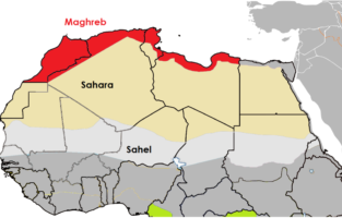
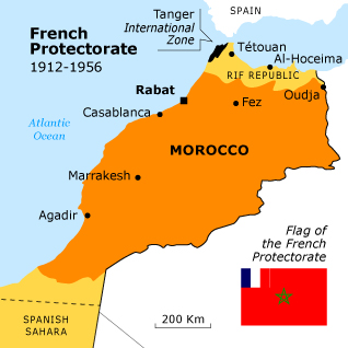
The nation of Morocco is in the northwest corner of Africa, with a coastline along the Atlantic Ocean, reaching past the Strait of Gibraltar into the Mediterranean Sea. It is bordered by Spain to the north (a water border through the Strait and land borders with three small Spanish-controlled exclaves, Ceuta, Melilla, and Peñón de Vélez de la Gomera), Algeria to the east, and Western Sahara to the south. Since Morocco controls most of Western Sahara, its de facto southern boundary is with Mauritania.
Dark green: Undisputed territory of Morocco. Lighter green: Western Sahara, a territory claimed and occupied mostly by Morocco as its Southern Provinces.
A large part of Morocco is mountainous, which isolates various villages and familial groups from one another, leading to the strong tribal and cultural divisions that have characterized the nation’s at times unstable political history.
The Atlas Mountains are rich in natural resources. There are deposits of iron ore, lead ore, copper, silver, mercury, rock salt, phosphate, marble, anthracite coal and natural gas among other resources.
The Rif Mountains stretch over the region bordering the Mediterranean from the north-west to the north-east. The Atlas Mountains run down the backbone of the country, from the northeast to the south west. Most of the southeast portion of the country is in the Sahara Desert – in the rain shadow of the Atlas Mountains – and as such is generally sparsely populated and unproductive economically. Most of the population lives to the north of these mountains, while to the south lies the Western Sahara, a former Spanish colony that was annexed by Morocco in 1975. Morocco claims that the Western Sahara is part of its territory and refers to that as its Southern Provinces, though its southern neighbor Mauritania contests this claim.
Morocco’s capital city is Rabat; its largest city is its main port, Casablanca. Other cities recording a population over 500,000 in the 2014 Moroccan census are Fes, Marrakesh, Meknes, Salé and Tangier.
Casablanca, located in the central-western part of Morocco and bordering the Atlantic Ocean, is the largest city in Morocco. It is also the largest city in the Maghreb region, as well as one of the largest and most important cities in Africa, both economically and demographically. Casablanca is Morocco’s chief port and one of the largest financial centers on the continent. According to the 2014 population estimate, the city has a population of about 3.35 million in the urban area.
The country’s Mediterranean climate is similar to that of southern California, with lush forests in the northern and central mountain ranges of the country, giving way to drier conditions and inland deserts further southeast. The Moroccan coastal plains experience remarkably moderate temperatures even in summer, owing to the effect of the cold Canary Current off its Atlantic coast.
The world’s ocean currents have a profound impact upon climates around the globe. The cold water of the Canary Current keeps temperatures on the coast of Morocco cool year round.
Prehistoric Morocco
Archaeological excavations have demonstrated the presence of people in Morocco that were ancestral to Homo sapiens, as well as the presence of early human species. The fossilized bones of a 400,000-year-old early human ancestor were discovered in Salé in 1971. The bones of several very early Homo sapiens were excavated at Jebel Irhoud in 1991, these were dated using modern techniques in 2017 and found to be at least 300,000 years old, making them the oldest examples of Homo Sapiens discovered anywhere in the world. In 2007, small perforated seashell beads were discovered in Taforalt that are 82,000 years old, making them the earliest known evidence of personal adornment found anywhere in the world.
Prehistoric rock engraving from Figuig, Morocco.
In Mesolithic times, between 20,000 and 5000 years ago, the geography of Morocco resembled a savanna more than the present arid landscape. While little is known of settlements in Morocco during that period, excavations elsewhere in the Maghreb region have suggested an abundance of game and forests that would have been hospitable to Mesolithic hunters and gatherers.
During the Neolithic period, which followed the Mesolithic, the savanna was occupied by hunters and herders. The culture of these Neolithic hunters and herders flourished until the region began to desiccate – or dry out – after 5000 BCE.
The indigenous – or native – people of North Africa are known as Berbers, and they make up the majority of Morocco’s population both in the modern day and throughout its three thousand year-old recorded history. The Berbers have historically been a people who practiced both settled agriculture and nomadic herding of animals. They have also developed extensive trade routes across the mountains and deserts of Morocco and North Africa generally, a region often referred to as the Maghreb. Berber society has historically been defined not by modern nation-states or empires, but by more local clans or tribes – extended familial and geographic identities. Modern Berbers are largely Sunni Muslim, but historically have practiced their own native religion, as well as Christianity and Judaism.
In the twenty-first century, Berbers pragmatically blend ancient patterns of life – such as the traditional kaftan style of dress – with modern developments – such as cell phones and satellite TV.
Morocco in Antiquity
Northwest Africa and Morocco were slowly drawn into the wider emerging Mediterranean world by the Phoenicians, who established trading colonies and settlements in the early Classical period.
The arrival of Phoenicians on the Moroccan coast heralded many centuries of rule by foreign powers in the north of Morocco. Phoenician traders penetrated the western Mediterranean before the 8th century BCE, and soon after set up depots for salt and ore along the coast and up the rivers of the territory of present-day Morocco.
By the 5th century BCE, the state of Carthage had extended its hegemony across much of North Africa. Carthage developed commercial relations with the Berber tribes of the interior, and paid them an annual tribute to ensure their cooperation in the exploitation of raw materials.
Mauretania was an independent tribal Berber kingdom on the Mediterranean coast of north Africa, corresponding to northern modern-day Morocco from about the 3rd century BCE. It became a client of the Roman empire in 33 BCE, then a full province after Emperor Caligula had the last king, Ptolemy of Mauretania, executed in AD 40.
Rome controlled the vast, ill-defined territory through alliances with the tribes rather than through military occupation, expanding its authority only to those areas, that were economically useful or that could be defended without additional manpower. Hence, Roman administration never extended outside the restricted area of the northern coastal plain and valleys. This strategic region formed part of the Roman Empire, governed as Mauretania Tingitana, with the city of Volubilis as its capital.
Volubilis is a partly excavated Berber city in Morocco situated near the city of Meknes, and commonly considered as the ancient capital of the kingdom of Mauretania. Built in a fertile agricultural area, it developed from the 3rd century BC onward as a Berber, then proto-Carthaginian, settlement before being the capital of the kingdom of Mauretania. It grew rapidly under Roman rule from the 1st century AD onward and expanded to cover about 42 hectares (100 acres) with a 2.6 km (1.6 mi) circuit of walls. The city gained a number of major public buildings in the 2nd century, including a basilica, temple and triumphal arch. Its prosperity, which was derived principally from olive growing, prompted the construction of many fine town-houses with large mosaic floors.
The Arch of Caracalla is one of Volubilis’ most distinctive sights, situated at the end of the city’s main street, the Decumanus Maximus. Although it is not architecturally outstanding, the triumphal arch forms a striking visual contrast with the smaller Tingis Gate at the far end of the decumanus. It was built in 217 by the city’s governor, Marcus Aurelius Sebastenus, to honour the emperor Caracalla and his mother Julia Domna. Caracalla was himself a North African and had recently extended Roman citizenship to the inhabitants of Rome’s provinces. However, by the time the arch was finished both Caracalla and Julia had been murdered by a usurper. The arch is constructed from local stone and was originally topped by a bronze chariot pulled by six horses. Statues of nymphs poured water into carved marble basins at the foot of the arch. Caracalla and Julia Domna were represented on medallion busts, though these have been defaced. The monument was reconstructed by the French between 1930–34. However, the restoration is incomplete and of disputed accuracy. The inscription on the top of the arch was reconstructed from the fragments noticed by Windus in 1722, which had been scattered on the ground in front of the arch.
The houses found at Volubilis range from richly decorated mansions to simple two-room mud-brick structures used by the city’s poorer inhabitants. The city’s considerable wealth is attested by the elaborate design of the houses of the wealthy, some of which have large mosaics still in situ.
The ruins remained substantially intact until they were devastated by an earthquake in the mid-18th century and subsequently looted by Moroccan rulers seeking stone for building Meknes. It was not until the latter part of the 19th century that the site was definitively identified as that of the ancient city of Volubilis.
Christianity was introduced to the region in the 2nd century AD, and gained converts in the towns and among slaves as well as among Berber farmers. By the end of the 4th century, the Romanized areas had been Christianized and inroads had been made among the Berber tribes, who sometimes converted en masse. Schismatic and heretical movements also developed, usually as forms of political protest. The area had a substantial Jewish population as well.
In the Islamic World
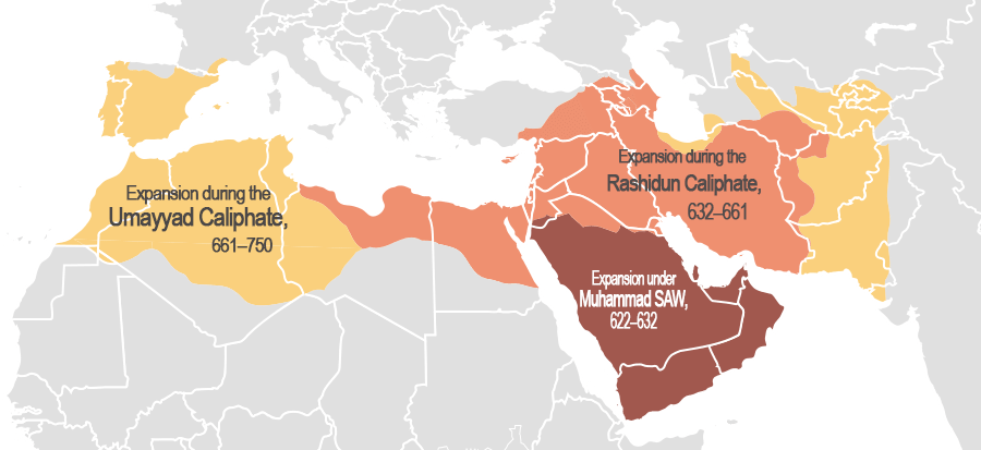
The Muslim conquest of the Maghreb, that started in the middle of the 7th century, was achieved by the Umayyad Caliphate early in the following century. It brought both the Arabic language and Islam to the area. The indigenous Berber tribes adopted Islam, but retained their customary laws. They also paid taxes and tribute to the new Muslim administration based in the city of Kairouan.
The Umayyad Caliphate (661–750 CE) was the second of the four major caliphates established after the death of Muhammad. The Umayyads continued the Muslim conquests, incorporating the Transoxiana, Sindh, the Maghreb and the Iberian Peninsula (Al-Andalus) into the Muslim world. At its greatest extent, the Umayyad Caliphate covered 11,100,000 km2 (4,300,000 sq mi) and 33 million people, making it one of the largest empires in history in both area and proportion of the world’s population. The dynasty was eventually overthrown by a rebellion led by the Abbasids in 750.
The Great Berber Revolt of 739/740–743 AD (122–125 AH in the Muslim calendar) marked the first successful secession from the Arab caliphate (ruled from Damascus). The Berber revolt against their Umayyad Arab rulers began in Tangiers in 740, and was led initially by Maysara al-Matghari. The revolt soon spread through the rest of the Maghreb (North Africa) and across the straits to al-Andalus (the Iberian Peninsula).
The Umayyads scrambled and managed to prevent the core of Ifriqiya (Tunisia, East-Algeria and West-Libya) and al-Andalus (Spain and Portugal) from falling into rebel hands. But the rest of the Maghreb was never recovered. After failing to capture the Umayyad provincial capital of Kairouan, the Berber rebel armies dissolved, and the western Maghreb fragmented into a series of small Berber statelets, ruled by tribal chieftains and Kharijite imams.
Some of the first Muslim states outside the Caliphate emerged from this revolt. In particular, this is sometimes regarded as the beginning of Moroccan independence, as Morocco would never again come under the rule of an eastern Caliph or any other foreign power until the 20th century.
Morocco was at its most powerful under a series of Berber dynasties, which rose to power south of the Atlas Mountains and expanded their rule northward, replacing local rulers. The 11th and 12th centuries witnessed the founding of several significant Berber dynasties led by religious reformers, each dynasty based on a tribal confederation that would dominate the Maghreb and Al-Andalus for more than 200 years. These dynasties – the Almoravids, Almohads, Marinids and Wattasids – gave the Berber people some measure of collective identity and political unity under a native regime for the first time in their history.
That is not to say that any of these dynasties were particularly stable or long-lasting – in fact, most rarely survived for more than three or four generations before chaotic in-fighting between heirs to the throne paved the way for the successive dynasty to rise up on the promise of political stability and religious reform, taking the previous dynasty’s place.
The Alaouite dynasty is the current Moroccan royal family. The Alaouite family claim descent from Muhammad through his daughter Fāṭimah az-Zahrah and her husband ‘Alī ibn Abī Ṭālib.
The kingdom was consolidated by Ismail Ibn Sharif (1672–1727), who began to create a unified state in the face of opposition from local tribes. Since the Alaouites, in contrast to previous dynasties, did not have the support of a single Berber or Bedouin tribe, Ismaīl controlled Morocco through an army of slaves. With these soldiers he drove the English from Tangiers (1684) and the Spanish from Larache in 1689. The unity of Morocco did not survive his death — in the ensuing power struggles the tribes became a political and military force once again, and it was only with Muhammad III (1757–1790) that the kingdom was unified again. The idea of centralization was abandoned and the tribes allowed to preserve their autonomy.
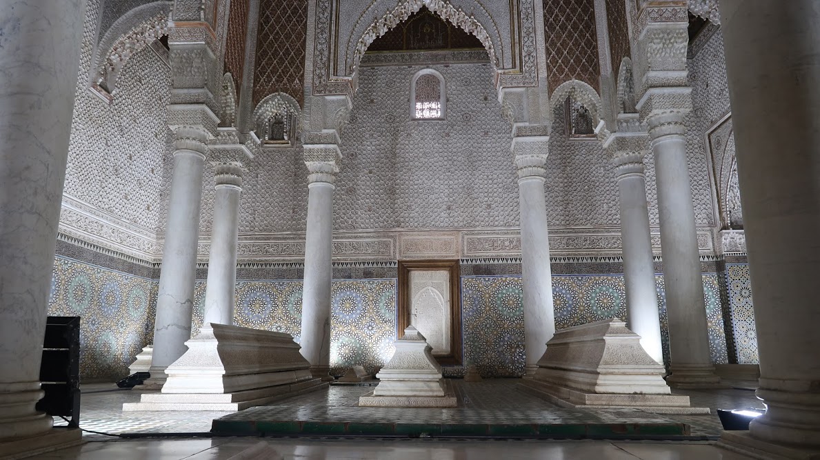
The Saadi dynasty was an Arab Moroccan dynasty, which ruled Morocco from 1549 to 1659. Their tombs, located in their capital of Marrakech, are the final resting place of some sixty members of the family, all buried with their heads toward Mecca, according to the Muslim tradition.
The Colonial Period
As Europe industrialised, Northwest Africa was increasingly prized for its potential for colonisation. France showed a strong interest in Morocco as early as 1830, not only to protect the border of its neighboring Algerian territory, but also because of the strategic position of Morocco with coasts on the Mediterranean and the open Atlantic. In 1860, a dispute over Spain’s Ceuta enclave led Spain to declare war. Victorious Spain won a further enclave and an enlarged Ceuta in the settlement. In 1884, Spain created a protectorate in the coastal areas of Morocco.
Tens of thousands of colonists entered Morocco. Some bought up large amounts of the rich agricultural land, others organised the exploitation and modernisation of mines and harbors. Interest groups that formed among these elements continually pressured France to increase its control over Morocco. Governor general Marshall Hubert Lyautey sincerely admired Moroccan culture and succeeded in imposing a joint Moroccan-French administration, while creating a modern school system.
The 1912 Treaty of Fez made Morocco an official protectorate of France, and triggered the 1912 Fez riots.
In 1943, the Istiqlal Party (Independence Party) was founded to press for independence, with discreet US support. That party subsequently provided most of the leadership for the nationalist movement.
In December 1952, a riot broke out in Casablanca over the murder of a Tunisian labor leader; this event marked a watershed in relations between Moroccan political parties and French authorities. In the aftermath of the rioting, the French government outlawed the Istiqlal.
France’s exile of the highly respected Sultan Mohammed V to Madagascar in 1953 – justified by his desire to pursue gradual independence – and his replacement by the unpopular Mohammed Ben Aarafa, sparked active opposition to the French protectorate both from nationalists and those who saw the sultan as a religious leader. Two years later, faced with a united Moroccan demand for the sultan’s return and rising violence in Morocco, the French government brought Mohammed V back to Morocco.
Sultan Muhammad V of Morocco wearing a jalaba in 1934. On 20 August 1953, the French who were occupying Morocco at the time forced Mohammed V and his family into exile on Corsica. His first cousin once removed, Mohammed Ben Aarafa, was placed on the throne. Mohammed V and his family were then transferred to Madagascar in January 1954. Mohammed V returned from exile on 16 November 1955, and was again recognized as Sultan after active opposition to the French protectorate. In February 1956 he successfully negotiated with France and Spain for the independence of Morocco, and in 1957 took the title of King.
In late 1955, in the middle of what came to be known as the Revolution of the King and the People, Sultan Mohammed V successfully negotiated the gradual restoration of Moroccan independence within a framework of French-Moroccan interdependence. The sultan agreed to institute reforms that would transform Morocco into a constitutional monarchy with a democratic form of government. Further negotiations for full independence culminated in the French-Moroccan Agreement signed in Paris on March 2, 1956.
On April 7, 1956, France officially relinquished its protectorate in Morocco.
In the months that followed independence, Mohammed V proceeded to build a modern governmental structure under a constitutional monarchy in which the sultan would exercise an active political role. He acted cautiously, intent on preventing the Istiqlal from consolidating its control and establishing a one-party state. He assumed the monarchy in 1957.
Upon the death of Mohammed V, Hassan II became King of Morocco on 3 March 1961. Morocco held its first general elections in 1963. However, Hassan declared a state of emergency and suspended parliament in 1965. In 1971, there was a failed attempt to depose the king and establish a republic. A truth commission set up in 2005 to investigate human rights abuses during his reign confirmed nearly 10,000 cases, ranging from death in detention to forced exile. Some 592 people were recorded killed during Hassan’s rule according to the truth commission.
The King Hassan II Mosque is the largest mosque in Africa, and the 5th largest in the world. Its minaret is the world’s second tallest minaret at 210 metres (689 ft). Mosque King Hassan II, son of Mohammed V, requested for the best of the country’s artisans to come forward and submit plans for a mausoleum to honour the departed king; it should “reflect the fervor and veneration with which this illustrious man was regarded.”
The walls are of hand-crafted marble and the roof is retractable. A maximum of 105,000 worshippers can gather together for prayer: 25,000 inside the mosque hall and another 80,000 on the mosque’s outside ground.
Construction costs, estimated to be about 585 million euro, were an issue of debate in Morocco, a lower mid-income country. While Hassan wished to build a mosque which would be second in size only to the mosque at Mecca, the government lacked funds for such a grand project. Much of the financing was by public subscription. Twelve million people donated to the cause, with a receipt and certificate given to every donor.
The mosque rises above the Atlantic Ocean. The building is built partially on land and partially over the ocean. Apart from the mosque, other structures in the area are a madrasa (Islamic school), hammams (bathhouses), a museum on Moroccan history, conference halls, and a very large library said to be the “most comprehensive in the Islamic world.”
Political reforms in the 1990s resulted in the establishment of a bicameral legislature in 1997 and Morocco’s first opposition-led government came to power in 1998.
With the death of King Hassan II of Morocco in 1999, the more liberal Crown Prince Sidi Mohammed took the throne, assuming the title Mohammed VI. He enacted successive reforms to modernize Morocco, and human-rights record of the country improved. One of the new king’s first acts was to free approximately 8,000 political prisoners held by his father, King Hassan II, and reduce the sentences of another 30,000. He also established a commission to compensate families of missing political activists and others subjected to arbitrary detention.
Morocco was an authoritarian regime according to the Democracy Index of 2014. The Freedom of the Press 2014 report gave it a rating of “Not Free.” This has improved since, however, and in 2017, Morocco was upgraded to being a “hybrid regime” according to the Democracy Index in 2017 and the Freedom of the Press report in 2017 found that Morocco was “partially free.”
Moroccan authorities continue to restrict the rights to peaceful expression, association and assembly through several laws. The authorities continue to prosecute both printed and online media which criticizes the government or the king. Homosexual acts are illegal in Morocco, and can be punishable by 6 months to 3 years of imprisonment. It is illegal to proselytize for any religion other than Islam, punishable by a maximum of 15 years of imprisonment.
On the other hand, tourism in Morocco is well developed, with a strong tourist industry focused on the country’s coast, culture, and history, welcoming 12.3 million tourists to a country of 36 million in 2018. Morocco has been one of the most politically stable countries in North Africa, which has allowed tourism to develop. Tourism is considered as one of the main foreign exchange sources in Morocco and since 2013 it had the highest number of arrivals out of any African country.
The country’s attractions can be divided into several regions:
The four Imperial cities — the four historical capital cities of Morocco: Fes, Marrakesh, Meknes, and Rabat, offering fantastic opportunities to learn about Berber history and culture
Casablanca — Morocco’s largest city; home of the Hassan II Mosque, which has the world’s tallest minaret at 656 feet
Tangier and the surrounding area, including the blue city, Chefchaouen
Ouarzazate — a noted film-making location; the fortified village (ksar) of Ait Benhaddou, which lies on the edge of the Sahara and was an important stop on the caravan trade
Essaouira, Agadir, and their beautiful Atlantic beaches
Fes – Morocco’s second largest city and it is the science and spiritual capital of Morocco, containing a medina, or old city, which is considered as the biggest area in the world where vehicles can’t get in. It is also the home of “Al Qarawyien” the world’s oldest university.
Citing specific examples, describe how the trans-Saharan trade linked Morocco to other regions of the world. Likewise, how does trade link your hometown to other regions of the world?
How does the camel make trans-Saharan trade possible? Throughout history, where and when have other animals extended or enhanced the potential of humans?
What factors lead to the rise of Islam in the West Africa? Consider ancient Morocco and your own country – how does joining a dominant religion or social group give advantages to converts, immigrants, or outsiders?
Taking inspiration from the griot tradition – using poetry, song, or visual art – tell the story of a journey along the trans-Saharan trade route from Timbuktu to Fez. Be as specific and tangible as you can. Represent the geography, the people, the trade goods, and anything else you might encounter on the way.
The Sahara Desert
The Sahara (Arabic: الصحراء الكبرى, aṣ-ṣaḥrāʾ al-kubrā , ‘the Greatest Desert’) is the largest hot desert and third largest desert after Antarctica and the Arctic worldwide. Its surface area is comparable to that of the United States. The desert comprises much of the land found within North Africa. The Sahara stretches from the Red Sea in the east and the Mediterranean in the north, to the Atlantic Ocean in the west, where the landscape gradually transitions to a coastal plain. To the south, it is bordered by the Sahel, a belt of semi-arid tropical savanna around the Niger River valley and Sudan Region of Sub-Saharan Africa – which was, from c. 1230 to c. 1600 – the homeland of the Mali Empire.
Morocco and the historic empires that preceded it have benefited greatly by controlling trade routes through the Atlas Mountains, which link the economies surrounding the Mediterranean Sea to those on the far side of the Sahara.
Increasing desertification and economic incentive
The Sahara once had a very different environment. In Libya and Algeria, from at least 7000 BC, there was pastoralism, herding of sheep and goats, large settlements and pottery. Cattle were introduced to the Central Sahara (Ahaggar) from 4000 to 3500 BC. Remarkable rock paintings (dated 3500 to 2500 BC), in places which are currently very dry, portray vegetation and animal presence rather different from modern expectations.
For several hundred thousand years, the Sahara has alternated between desert and savanna grassland in a 41,000 year cycle caused by the precession of the Earth’s axis as it rotates around the Sun, which changes the location of the North African Monsoon. The area is next expected to become green in about 15,000 years (17,000 AD). There is a suggestion that the last time that the Sahara was converted from savanna to desert it was partially due to overgrazing by the cattle of the local population.
As a desert, Sahara is now a hostile expanse that separates the Mediterranean economy from the economy of the Niger basin. Crossing such a zone (especially without mechanized transport like a train or truck) is worthwhile only when exceptional circumstances cause the expected gain to outweigh the cost and danger. The Sahara has always been home to groups of people practicing trade on a regular, if only local basis.
The Sahara covers 9 million square kilometres (3,500,000 sq mi), amounting to 31% of Africa. It is mainly rocky hamada (stone plateaus); ergs (sand seas – large areas covered with sand dunes, as pictured above) form only a minor part. Other distinctive features of the Sahara include gravel plains (reg), dry valleys (wadi), dry lakes (oued), and salt flats (shatt or chott).
The Camel
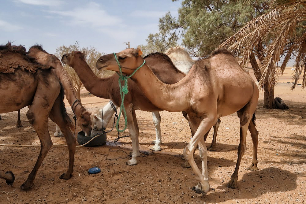
Camels water before a short trek across a sand sea. Camels do not directly store water in their humps; they are reservoirs of fatty tissue. Concentrating body fat in their humps minimizes the insulating effect fat would have if distributed over the rest of their bodies, helping camels survive in hot climates. The dromedary camel can drink as seldom as once every 10 days even under very hot conditions, and can lose up to 30% of its body mass due to dehydration.
Although they rarely travel faster than the walking speed of a man, camels’ ability to withstand harsh conditions made them ideal for communication and trade in the desert areas of North Africa and the Arabian Peninsula for centuries, though they could only travel on routes with sufficient sources of food and water. The animals transformed the economy and culture of the Sahara.
Camels have a series of physiological adaptations that allow them to withstand long periods of time without any external source of water. Unlike other mammals, their red blood cells are oval rather than circular in shape. This facilitates the flow of red blood cells during dehydration and makes them better at withstanding high osmotic variation without rupturing when drinking large amounts of water: a 1,300 lb camel can drink 53 gallons of water in three minutes.
Camels can close their nostrils the same way humans can blink their eyes, an adaptation that allows them close out the sand that sometimes blows fiercely across the desert. Long eyelashes and ear hairs also form a barrier against sand. If sand gets lodged in their eyes, they can dislodge it using their transparent third eyelid.
When the camel exhales, water vapor becomes trapped in their nostrils and is reabsorbed into the body as a means to conserve water. Camels eating green herbage can ingest sufficient moisture in milder conditions to maintain their bodies’ hydrated state without the need for drinking.
Camels do not directly store water in their humps as was once commonly believed. The humps are actually reservoirs of fatty tissue: concentrating body fat in their humps minimizes the insulating effect fat would have if distributed over the rest of their bodies, helping camels survive in hot climates. When this tissue is metabolized, it yields more than one gram of water for every gram of fat processed.
Camels are able to withstand changes in body temperature and water consumption that would kill most other animals. Their body temperature ranges from 93 °F at dawn and steadily increases to 104 °F by sunset, before they cool off at night again. Maintaining the brain temperature within certain limits is critical for animals; to assist this, camels have a rete mirabile, a complex of arteries and veins lying very close to each other which utilizes countercurrent blood flow to cool blood flowing to the brain. Camels rarely sweat, even when ambient temperatures reach 120 °F.
Camels lying in sternal recumbency, a position that aids heat loss. Dromedaries have a pad of thick tissue over the sternum called the pedestal. When the animal lies down in a sternal recumbent position, the pedestal raises the body from the hot surface and allows cooling air to pass under the body.
Camels’ mouths have a thick leathery lining, allowing them to chew thorny desert plants. Camels eating green herbage can ingest sufficient moisture in milder conditions to maintain their bodies’ hydrated state without the need for drinking.
Camel’s feet are leathery and broad, distributing their weight over the sand more evenly – they can walk easily over sand that into which a horse’s hooves would sink.
Humans may have first domesticated dromedaries in Somalia and southern Arabia around 3,000 BC.
Camels’ mouths have a thick leathery lining, allowing them to chew thorny desert plants. Long eyelashes and ear hairs, together with nostrils that can close, form a barrier against sand. If sand gets lodged in their eyes, they can dislodge it using their transparent third eyelid. The camels’ gait and widened feet help them move without sinking into the sand. The kidneys and intestines of a camel are very efficient at reabsorbing water. Camel urine comes out as a thick syrup, and camel feces is so dry that they do not require any additional processing when desert peoples use them to fuel fires.
The Ultimate Desert Technology
People have been using camels for over 4,000 years mostly as pack animals and for transportation. Camels came to north Africa from Arabia, by way of Egypt and the Sudan, coming into widespread use by 300 CE, replacing horses and donkeys as the preferred means of transportation across the Sahara. A caravan of camels took 70 to 90 days to cross the Sahara, so the camel’s ability to travel long distances without water made trans-Saharan trade possible. In short, adoption of domesticated camels represented the ultimate in desert technology.
A funduq was a rest stop for merchants traveling along the Saharan trade routes. Most typically a funduq was a building with a square or rectangular walled exterior, with a single portal wide enough to permit large or heavily laden beasts such as camels to enter. The courtyard was almost always open to the sky, and the inside walls of the enclosure were outfitted with a number of identical animal stalls, bays, niches or chambers to accommodate merchants and their servants, animals, and merchandise. Funduqs provided water for human and animal consumption, washing and ritual purification – that is, washing before prayer or eating. Sometimes they had elaborate baths. They also kept fodder for animals and had shops for travelers where they could acquire new supplies. In addition, some shops bought goods from the travelling merchants.
The Sahara is dry and harsh – but resourceful humans learned long ago how to make the most of it to raise food and facilitate long distance trade. The location of oases has been of critical importance for trade and transportation routes in desert areas; caravans must travel via oases so that supplies of water and food can be replenished. Thus, political or military control of an oasis has in many cases meant control of trade on a particular route. People who live in an oasis must manage land and water use carefully; fields must be irrigated to grow plants like apricots, dates, figs, and olives. The most important plant in an oasis is the date palm, which forms the upper layer. These palm trees provide shade for smaller trees like peach trees, which form the middle layer. By growing plants in different layers, the farmers make best use of the soil and water. Many vegetables are also grown and some cereals, such as barley, millet, and wheat, are grown where there is more moisture.
Caravan Trade
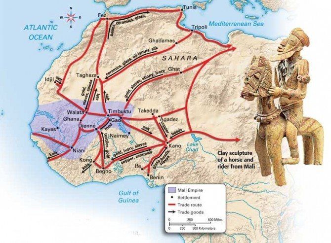
Camels would be fattened for a number of months on the plains of either the Maghreb or the Sahel before being assembled into a caravan. According to Ibn Battuta, the famous Muslim explorer who accompanied one of the caravans, the average size per caravan was 1,000 camels; some caravans were as large as 12,000. Various Trans-Saharan trade routes connected sub- Saharan West Africa to the Mediterranean coast. Among the commodities carried southward were silk, cotton, horses, and salt. Among those carried northward were gold, ivory, pepper, and slaves.
Caravans would be guided by highly paid Berbers who knew the desert and could ensure safe passage from their fellow desert nomads. The survival of a caravan was precarious and would rely on careful coordination and knowledge of the land. Runners would be sent ahead to oases so that water could be shipped out to the caravan when it was still several days away, as the caravans could not easily carry enough with them to make the full journey.
Aït Benhaddou is an ighrem (fortified village in English) along the former caravan route between the Sahara and Marrakech in present-day Morocco. Such villages offered a walled refuge – complete with fresh water – for caravans traveling between Timbuktu and Marrakech, along the harsh Sahara trade routes.
Mediterranean economies were short of gold, but could supply salt, whereas West African countries had plenty of gold but needed salt. The trans-Saharan slave trade was also important because large numbers of Africans were sent north, generally to serve as domestic servants or slave concubines. The West African states imported highly trained slave soldiers. It has been estimated that from the 10th to the 19th century some 6,000 to 7,000 slaves were transported north each year. Perhaps as many as nine million slaves were exported along the trans-Saharan caravan route.
The Arrival of Islam
Merchants transported more than valuable commodities along the trans-Saharan routes. Just as Buddhism reached the Chinese Empire via Indian merchants traveling the Silk Road, Islam reached West Africa through Arab merchants on Saharan caravan routes. Arab merchants brought the Koran and the written language of Arabic to traditionally oral cultures in West Africa. The extensive trade networks throughout North and West Africa created a medium through which Islam spread peacefully, initially through the merchant class. By sharing a common religion and a common language (Arabic), traders showed greater willingness to trust, and therefore invest, in one another.
Sharing a meal, sharing a culture.
The British Museum describes the process of conversion in West Africa:
It was Arab traders who first brought the new religion to the kingdom of Mali. Many of them were educated and religious men who through speech and the books of learned writers managed to spread the word. Malians who became traders, and who moved further from their roots, began abandoning their old religion and adopting Islam which proved a passport for entry into northern markets. Traders were followed by Arab immigrants who came as judges, imams and teachers and who settled in the country. They were treated with respect and one Mansa (king) even married his daughters to two of them. Mosques were built, and Islamic influences were felt in architecture, poetry, cooking and even dress. Men were sent to study in Moroccan madrasas (religious schools). Timbuktu became a major centre of Islamic culture and learning. Even so, in the villages much of the old religion remained, and Ibn Battuta was shocked to discover, even at court, old ceremonial dances being performed during an Islamic religious festival.
The Great Mali Empire
During the 13th and 14th centuries, the great Mali Empire owed its prosperity to its position at the center of a network of caravan trade routes which criss-crossed West Africa, linking sub-Saharan Africa, the Islamic world, and the Mediterranean. The empire was founded in 13th Century by Sundiata Keita, whose exploits remain celebrated in Mali today.
Sundiata Keita
From the British Museum:
Sunjata (r. 1235–1255) was the first king to unify the Mandinka kingdoms and is as much a figure of legend as of fact. Epic songs of the griots tell of the ‘magician’ Sunjata who, when the Mandinka could no longer bear the burden of paying taxes to their Sosso leader Sumanguru, led them into battle. Sunjata killed Sumanguru at the Battle of Krina in 1235, and seized the major territories through which gold was traded. Sunjata declared himself Mansa (King of Kings) of the twelve kingdoms of the Mandinka. The 12 kings swore to obey Sunjata in return for being named governors of their territories. To help him rule, Sunjata set up a Gbara, or Great Assembly, of clan elders who would discuss and make decisions. Over the next two centuries the kingdom would expand through war, until it covered 1.3 million km2 . Sunjata’s successor Ali is credited with conquering the great trading centres of Timbuktu and Djenné.
An Oral History
A griot in modern Mali.
There are a few written accounts of this period, because West African society relied on a tradition of oral history passed down by griots (professional storytellers). Our picture of the Mali Empire comes mainly from the modern continuation of this oral tradition, archaeological research, the extant remains of cities, and the accounts of a few visiting writers.
In addition to royal griots who served the court, most villages also had their own griot, who told tales of births, deaths, marriages, battles, hunts, affairs, and hundreds of other things.
Francis Bebey writes about the griot in his book African Music, A People’s Art (Lawrence Hill Books):
“The West African griot is a troubadour, the counterpart of the medieval European minstrel… The griot knows everything that is going on… He is a living archive of the people’s traditions… The virtuoso talents of the griots command universal admiration. This virtuosity is the culmination of long years of study and hard work under the tuition of a teacher who is often a father or uncle.
Mali’s Economy
With an economy built on the basis of the trans-Saharan trade, the Mali Empire was the largest and longest lasting kingdom in the history of West Africa. It profoundly influenced the culture of the region through the spread of its language, laws and customs along the Niger River, which ran through the heart of the empire. The empire contained three immense gold mines – Bambuk, Boure and Galam within its borders, by some estimates accounting for nearly half the gold supply in Africa, Asia, and Europe from the 12th century on. The empire taxed every ounce of gold, copper, and salt that crossed its borders.
Gold
Gold nuggets were the exclusive property of the mansa (king), and were illegal to trade within his borders. All gold was immediately handed over to the imperial treasury in return for an equal value of gold dust. Gold dust had been weighed and bagged for use at least since the reign of the Ghana Empire. Mali borrowed the practice to stem inflation of the substance, since it was so prominent in the region. The most common measure for gold within the realm was the ambiguous mithqal (4.5 grams of gold). This term was used interchangeably with dinar, though it is unclear if coined currency was used in the empire. Gold dust was used all over the empire, but was not valued equally in all regions.
Panning for gold is still a common – if challenging – livelihood in some West African nations.
Slaves
Similar to Christianity of the time, Islamic Sharia law allowed slavery, but prohibited slavery involving other preexisting Muslims; as a result, the main target for slavery were the people who lived in the frontier areas of Islam in Africa, in the Sahara and Sahel. Bernard Lewis writes that “polytheists and idolaters were seen primarily as sources of slaves, to be imported into the Islamic world and molded in Islamic ways, and, since they possessed no religion of their own worth the mention, as natural recruits for Islam.”
Large numbers of Africans were sent north, generally to serve as domestic servants or slave concubines. The West African states imported highly trained slave soldiers. It has been estimated that from the 10th to the 19th century some 6,000 to 7,000 slaves were transported north each year.
Salt
Rock salt at the market in Mopti. It is sold here in slabs, broken and weighed, and packaged into smaller amounts.
The next great unit of exchange in the Mali Empire was salt. Salt was as valuable, if not more valuable than gold in Sub-Saharan Africa. Salt is produced in the Sahara (and has been for over 2½ thousand years-mentioned by Herodotus) at several places. Since ancient times, salt has been used to flavor and preserve food. Salt was either extracted from evaporating pools or mined from underground, left behind from dried up ancient seabeds. It was cut into pieces and spent on goods with close to equal buying power throughout the empire. While it was as good as gold in the north, it was even better in the south. Salt was relatively rare in the south. The northern region on the other hand had no shortage of salt. Every year merchants entered Mali via Oualata with camel loads of salt to sell in Niani. According to Ibn Battuta who visited Mali in the mid-14th century, one camel load of salt sold at the northern trading post of Walata for 8–10 mithkals of gold, but in Mali proper it was worth 20–30 ducats and sometimes even 40. One particular source of salt in the Mali empire were salt-mining sites located in Taghaza. Ibn Battuta wrote that in Taghaza there were no trees and there is only sand and the salt mines. Nobody lived in the area except the Musafa slaves who working to dug the salts and lived on imported dates, camel meat, and millet imported from the Sudan. The buildings were even constructed from slabs of salt and roofed with camel skins. The salt was dug from the ground and cut into thick slabs, two of which were loaded onto each camel where they will be taken south across the desert and sold.
Salt, mined from large deposits, is loaded onto boats on the Niger River.
No government can rule a nation if there is no economic activity to feed the people. Moroccan cities such as Fez and Marrakech appear to be landlocked on any map – they are nowhere near the ocean. But in a very real sense, they are ports on the edge of a great sea – the Sahara. Along with their neighbors to the south in Mali, the Berbers of Morocco became sailors on that sea, moving goods in great caravans on the backs of camels. Control of the last leg of the Saharan trade routes fueled the rise of Moroccan dynasties such as the Almoravids and Almohads. The people of Morocco have long benefitted from their unique geographic perch – building an enterprising and resourceful civilization based on trade that straddles the Mediterranean and sub-Saharan worlds.
This restaurant in modern day Fez was once a fantastic private residence – built and maintained by wealth hard-earned in the trans-Saharan trade.
One set among the dozens of front doors to the royal palace in Fez, each featuring intricate decorative work produced at great expense – again, paid for through taxes on the trans-Saharan trade.
This is the Al-Attarine madrasa – the ancient equivalent of a high school in the Muslim world. Built in Fez between 1323 and 1325, its stunning woodwork and stucco detailing were funded via tax revenue from the trans-Saharan trade.
THIS LESSON WAS MADE POSSIBLE THROUGH A GENEROUS GRANT FROM THE QATAR FOUNDATION.


 Moroccans, like many Muslims, look for a leader who has a quality they call barakah – blessed by God. This quality can be demonstrated in many ways – the leader brings prosperity to the country, he leads the army to great victories, a drought ends on his watch. It must have seemed miraculous to these Berbers, living at an unremarkable juncture on the Saharan trade routes that a descendant of the Prophet had come to live among them, and before long he was their leader, further demonstrating his barakah by conquering many neighboring Berber tribes and founding the Idrisid Dynasty, the first great Moroccan-based empire, with Fes as its capital.


 Morocco’s capital city is Rabat; its largest city is its main port, Casablanca. Other cities recording a population over 500,000 in the 2014 Moroccan census are Fes, Marrakesh, Meknes, Salé and Tangier.


 The indigenous – or native – people of North Africa are known as Berbers, and they make up the majority of Morocco’s population both in the modern day and throughout its three thousand year-old recorded history. The Berbers have historically been a people who practiced both settled agriculture and nomadic herding of animals. They have also developed extensive trade routes across the mountains and deserts of Morocco and North Africa generally, a region often referred to as the Maghreb. Berber society has historically been defined not by modern nation-states or empires, but by more local clans or tribes – extended familial and geographic identities. Modern Berbers are largely Sunni Muslim, but historically have practiced their own native religion, as well as Christianity and Judaism.


You must be logged in to post a comment.