A Basic History of Morocco (Free online text suited for middle or high school classroom use, guided reading questions, and suggested activities): A brief overview of the geography, culture, and history of Morocco.
The Berbers: A Free and Noble People (Free online text suited for middle or high school classroom use, guided reading questions, and suggested activities): Who are the Berber, and what makes them a distinct and special people?
The Sahara, Camel, and the Caravan Trade (Free online text suited for middle or high school classroom use, guided reading questions, and suggested activities): Highlighting the role of the caravan trade in Morocco’s ancient economy. That trade was made possible in large part by the camel, which allowed Berber, Arab, and sub-Saharan peoples to traverse the harsh Sahara desert, moving trade goods, and establishing religious and cultural connections where none could otherwise exist.
Fes: Center of Moroccan Empire and Culture (Free online text suited for middle or high school classroom use, guided reading questions, and suggested activities): The first capital of a united Morocco has been a dynamic player in culture, education, and the economy of North Africa for more than a thousand years.
The Medina: Sustainable Cities of the Ancient World (Free online text suited for middle or high school classroom use, guided reading questions, and suggested activities): Examining the characteristics of a traditional medina, and evaluating those traits as a possible template for a more walkable, communal, sustainable future.
Chefchaouen and the Moroccan Quest for Independence (Free online text suited for middle or high school classroom use, guided reading questions, and suggested activities): Exploring Morocco’s experiences as an imperial power – and as the subject of imperial power from abroad. This history has shaped a distinctive culture at the crossroads of the Mediterranean, European, and African worlds.
Background on Islam, the dominant religion in Morocco:
Muhammad, the Prophet of Islam (Free online text suited for middle or high school classroom use, guided reading questions, and suggested activities): Who was Muhammad, and how did the Arab world of the seventh century shape his teachings?
Five Pillars to Hold Me Up: What Do Muslims Believe? (Free online text suited for middle or high school classroom use, guided reading questions, and suggested activities):What are the basic teachings of Islam, and what does it mean to be a Muslim?
Idris and the wealthy elite of ancient Fes filled the city with fountains, madrasas (schools), library, the world’s first university, and community ovens for baking bread. They also built strong walls and thick gates to protect the residents of Fez – and traveling merchants spending the night. What kind of services and amenities does your city government provide for you? Did the people of Fes get better or worse care than you do?
How similar are the classes described at University of al-Qarawiyyin to those conducted in your school? Compare and contrast these two educational institutions.
The prosperous economy of Fes was based on its position along the trade routes linking sub-Saharan Africa and the Mediterranean world. What is the economy of your town based on? Provide specific industries, companies, dollar values, percentages, and numbers of people if you can. Do these industries make your town relatively wealthy, while employing a large number of people? How does the unemployment rate in your town compare that of the rest of your country?
Fes is the ancient capital of the first unified Moroccan state, founded in 803 CE when Idris I, the great-great-great grandson of Muhammad the Prophet, subdued local Berber tribes.
Idris I was a refugee of sorts – a member of the ruling class of the largest Arab empire based in Baghdad. A successful rebellion led to the death of his brothers, and he fled west, across the harsh Sahara to the land known as the Maghreb – today`s Morocco. There, he settled near the ruins of Roman Volubilis, where he was welcomed by the local Berber tribe – many of whom had converted to Islam after the religion was carried alongside gold, spices, and ivory in the trans-Saharan trade.
Moroccans, like many Muslims, look for a leader who has a quality they call barakah – blessed by God. This quality can be demonstrated in many ways – the leader brings prosperity to the country, he leads the army to great victories, a drought ends on his watch. It must have seemed miraculous to these Berbers, living at an unremarkable juncture on the Saharan trade routes that a descendant of the Prophet had come to live among them, and before long he was their leader, further demonstrating his barakah by conquering many neighboring Berber tribes and founding the Idrisid Dynasty, the first great Moroccan-based empire, with Fes as its capital.
As these thing go, this success ruined his hiding spot. The Arab rebels – known as the Abbasids – who had killed his family and sent him into hiding, eventually had Idris I assassinated, too.
Fez’s Palais Royale may be a modern palace, but it hints at the fantastic wealth of Idris I’s ancient capital. These large brass doors stand nearly a dozen feet tall. They are surrounded by sumptuous zellige (colorful geometric mosaic tilework) and carved cedar wood.
His son, Idris II attained even greater success in unifying the Maghreb. Fes was an important part of this success, as it occupies a pass in the Rif Mountains – guarding a main trade route between the Sahara and the Mediterranean Coast. Placing his capital at Fes meant that Idris could wield economic as well as military power over his people at their neighbors. He could tax goods as they moved through Fes’s many markets and funduqs. He could use this revenue to fund massive unlicensed works – fountains to provide beauty and freshwater to the city’s residents, for example, or communal ovens and local schools. Fes’s residents were merchants and innkeepers who prospered on his watch. In short, the quality of life for the average Berber under Idris I and II was pretty good. This is the epitome of barakah – which flows from God to those that are closest to God, such as saints and prophets. Those that have received barakah are thought to have the abilities to perform miracles (karamat) – in the case of a king, this could mean bringing peace and prosperity, good harvests, and good health to his people.
While it is not exactly the same thing, barakah could loosely be compared to what Enlightenment thinkers in Europe might have called “the social contract.” If the people of a kingdom are happy and safe, they will accept the rule of their emir. Idris could exercise all of this “soft power” before ever ordering a single act of violence or repression by his great army – and why would he ever need to do anything by force when life for his subjects was so good?
Under Idris, the souks – or markets – of Fes were flooded with trade goods from across the African and Mediterranean worlds.
For its part, Fes became a major producer of leather goods. Tanneries such as this one still produce fine leather using many of the same techniques they have for more than a thousand years.
A man and his son drop animal hides – goats, cows, or camels, usually – into vats of chemicals, which dye and preserve the skins as leather.
The end result of this process is a colorful array of bags, clothing, and other leather goods.
The fine artisans of Morocco produce intricate tilework by hand, a trade that has persisted for more than a thousand years. Then, as now, their detailed work is expensive – a sign of status whether it adorns a palace wall or the floors of a riad, or wealthy person’s home.
This riad likely belonged to a wealthy merchant in some distant past. This cedar wood likely came to Fes along the trade routes that passed through the city, and it was hand carved and painted by local artisans – a sign of great status on the part of the man who once owned this home.
Fes became the center of culture and learning in the Maghreb. While most Europeans of the time were living in what a previous generation of historians called “The Dark Ages,” in Fes, the world’s oldest functioning university – University of al-Qarawiyyin – began operation in 859 CE.
Al Quaraouiyine was founded with an associated madrasa, in 859 by Fatima al-Fihri, the daughter of a wealthy merchant named Mohammed Al-Fihri. Fatima and her sister Mariam, both of whom were well educated, inherited a large amount of money from their father. Fatima vowed to spend her entire inheritance improving the quality of life for her community.
As it has for over 1100 years, education at Al Quaraouiyine University concentrates on the Islamic religious and legal sciences with a heavy emphasis on, and particular strengths in, Classical Arabic grammar/linguistics and Islamic law, although a few lessons on other non-Islamic subjects such as French, English are also offered to students. Teaching is delivered in the traditional method, in which students are seated in a semi-circle (halqa) around a sheikh, who prompts them to read sections of a particular text, asks them questions on particular points of grammar, law, or interpretation, and explains difficult points. Students from all over Morocco and Islamic West Africa attend the Qarawiyyin, although a few might come from as far afield as Muslim Central Asia. Even Spanish Muslim converts frequently attend the institution, largely attracted by the fact that the sheikhs of the Qarawiyyin, and Islamic scholarship in Morocco in general, are heirs to the rich religious and scholarly heritage of Muslim al-Andalus.
Most students at the Qarawiyyin range from between the ages of 13 and 30, and study towards high school-level diplomas and university-level bachelor’s degrees, although Muslims with a sufficiently high level of Arabic are also able to attend lecture circles on an informal basis, given the traditional category of “visitors in search of knowledge.”
After the reign of Idris II, the dynasty began to fracture. Royal brother fought royal brother for control of the empire. They would eventually be conquered by a new dynasty arising in the south of Morocco, but the owing to its status as a center of trade and learning, the glory of Fes would not really fade.
Fes remains perhaps the greatest symbol of Morocco, a country at the crossroads of Africa, Europe, and the Mediterranean, reflected in the cosmopolitan flavor of a city founded by an Arab ruler leading a pan-Berber empire, accepting immigrants from as far afield as modern Spain, and protecting the diversity of Jews and Christians who have long called the city home.
THIS LESSON WAS MADE POSSIBLE THROUGH A GENEROUS GRANT FROM THE QATAR FOUNDATION.
Citing specific examples, describe how the trans-Saharan trade linked Morocco to other regions of the world. Likewise, how does trade link your hometown to other regions of the world?
How does the camel make trans-Saharan trade possible? Throughout history, where and when have other animals extended or enhanced the potential of humans?
What factors lead to the rise of Islam in the West Africa? Consider ancient Morocco and your own country – how does joining a dominant religion or social group give advantages to converts, immigrants, or outsiders?
Taking inspiration from the griot tradition – using poetry, song, or visual art – tell the story of a journey along the trans-Saharan trade route from Timbuktu to Fez. Be as specific and tangible as you can. Represent the geography, the people, the trade goods, and anything else you might encounter on the way.
The Sahara Desert
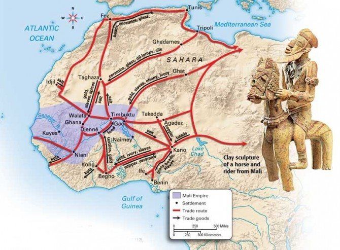
The Sahara (Arabic: الصحراء الكبرى, aṣ-ṣaḥrāʾ al-kubrā , ‘the Greatest Desert’) is the largest hot desert and third largest desert after Antarctica and the Arctic worldwide. Its surface area is comparable to that of the United States. The desert comprises much of the land found within North Africa. The Sahara stretches from the Red Sea in the east and the Mediterranean in the north, to the Atlantic Ocean in the west, where the landscape gradually transitions to a coastal plain. To the south, it is bordered by the Sahel, a belt of semi-arid tropical savanna around the Niger River valley and Sudan Region of Sub-Saharan Africa – which was, from c. 1230 to c. 1600 – the homeland of the Mali Empire.
Morocco and the historic empires that preceded it have benefited greatly by controlling trade routes through the Atlas Mountains, which link the economies surrounding the Mediterranean Sea to those on the far side of the Sahara.
Increasing desertification and economic incentive
The Sahara once had a very different environment. In Libya and Algeria, from at least 7000 BC, there was pastoralism, herding of sheep and goats, large settlements and pottery. Cattle were introduced to the Central Sahara (Ahaggar) from 4000 to 3500 BC. Remarkable rock paintings (dated 3500 to 2500 BC), in places which are currently very dry, portray vegetation and animal presence rather different from modern expectations.
For several hundred thousand years, the Sahara has alternated between desert and savanna grassland in a 41,000 year cycle caused by the precession of the Earth’s axis as it rotates around the Sun, which changes the location of the North African Monsoon. The area is next expected to become green in about 15,000 years (17,000 AD). There is a suggestion that the last time that the Sahara was converted from savanna to desert it was partially due to overgrazing by the cattle of the local population.
As a desert, Sahara is now a hostile expanse that separates the Mediterranean economy from the economy of the Niger basin. Crossing such a zone (especially without mechanized transport like a train or truck) is worthwhile only when exceptional circumstances cause the expected gain to outweigh the cost and danger. The Sahara has always been home to groups of people practicing trade on a regular, if only local basis.
The Sahara covers 9 million square kilometres (3,500,000 sq mi), amounting to 31% of Africa. It is mainly rocky hamada (stone plateaus); ergs (sand seas – large areas covered with sand dunes, as pictured above) form only a minor part. Other distinctive features of the Sahara include gravel plains (reg), dry valleys (wadi), dry lakes (oued), and salt flats (shatt or chott).
The Camel
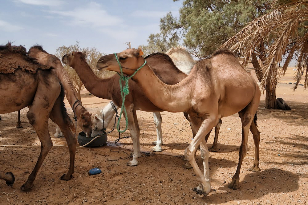
Camels water before a short trek across a sand sea. Camels do not directly store water in their humps; they are reservoirs of fatty tissue. Concentrating body fat in their humps minimizes the insulating effect fat would have if distributed over the rest of their bodies, helping camels survive in hot climates. The dromedary camel can drink as seldom as once every 10 days even under very hot conditions, and can lose up to 30% of its body mass due to dehydration.
Although they rarely travel faster than the walking speed of a man, camels’ ability to withstand harsh conditions made them ideal for communication and trade in the desert areas of North Africa and the Arabian Peninsula for centuries, though they could only travel on routes with sufficient sources of food and water. The animals transformed the economy and culture of the Sahara.
Camels have a series of physiological adaptations that allow them to withstand long periods of time without any external source of water. Unlike other mammals, their red blood cells are oval rather than circular in shape. This facilitates the flow of red blood cells during dehydration and makes them better at withstanding high osmotic variation without rupturing when drinking large amounts of water: a 1,300 lb camel can drink 53 gallons of water in three minutes.
Camels can close their nostrils the same way humans can blink their eyes, an adaptation that allows them close out the sand that sometimes blows fiercely across the desert. Long eyelashes and ear hairs also form a barrier against sand. If sand gets lodged in their eyes, they can dislodge it using their transparent third eyelid.
When the camel exhales, water vapor becomes trapped in their nostrils and is reabsorbed into the body as a means to conserve water. Camels eating green herbage can ingest sufficient moisture in milder conditions to maintain their bodies’ hydrated state without the need for drinking.
Camels do not directly store water in their humps as was once commonly believed. The humps are actually reservoirs of fatty tissue: concentrating body fat in their humps minimizes the insulating effect fat would have if distributed over the rest of their bodies, helping camels survive in hot climates. When this tissue is metabolized, it yields more than one gram of water for every gram of fat processed.
Camels are able to withstand changes in body temperature and water consumption that would kill most other animals. Their body temperature ranges from 93 °F at dawn and steadily increases to 104 °F by sunset, before they cool off at night again. Maintaining the brain temperature within certain limits is critical for animals; to assist this, camels have a rete mirabile, a complex of arteries and veins lying very close to each other which utilizes countercurrent blood flow to cool blood flowing to the brain. Camels rarely sweat, even when ambient temperatures reach 120 °F.
Camels lying in sternal recumbency, a position that aids heat loss. Dromedaries have a pad of thick tissue over the sternum called the pedestal. When the animal lies down in a sternal recumbent position, the pedestal raises the body from the hot surface and allows cooling air to pass under the body.
Camels’ mouths have a thick leathery lining, allowing them to chew thorny desert plants. Camels eating green herbage can ingest sufficient moisture in milder conditions to maintain their bodies’ hydrated state without the need for drinking.
Camel’s feet are leathery and broad, distributing their weight over the sand more evenly – they can walk easily over sand that into which a horse’s hooves would sink.
Humans may have first domesticated dromedaries in Somalia and southern Arabia around 3,000 BC.
Camels’ mouths have a thick leathery lining, allowing them to chew thorny desert plants. Long eyelashes and ear hairs, together with nostrils that can close, form a barrier against sand. If sand gets lodged in their eyes, they can dislodge it using their transparent third eyelid. The camels’ gait and widened feet help them move without sinking into the sand. The kidneys and intestines of a camel are very efficient at reabsorbing water. Camel urine comes out as a thick syrup, and camel feces is so dry that they do not require any additional processing when desert peoples use them to fuel fires.
The Ultimate Desert Technology
People have been using camels for over 4,000 years mostly as pack animals and for transportation. Camels came to north Africa from Arabia, by way of Egypt and the Sudan, coming into widespread use by 300 CE, replacing horses and donkeys as the preferred means of transportation across the Sahara. A caravan of camels took 70 to 90 days to cross the Sahara, so the camel’s ability to travel long distances without water made trans-Saharan trade possible. In short, adoption of domesticated camels represented the ultimate in desert technology.
A funduq was a rest stop for merchants traveling along the Saharan trade routes. Most typically a funduq was a building with a square or rectangular walled exterior, with a single portal wide enough to permit large or heavily laden beasts such as camels to enter. The courtyard was almost always open to the sky, and the inside walls of the enclosure were outfitted with a number of identical animal stalls, bays, niches or chambers to accommodate merchants and their servants, animals, and merchandise. Funduqs provided water for human and animal consumption, washing and ritual purification – that is, washing before prayer or eating. Sometimes they had elaborate baths. They also kept fodder for animals and had shops for travelers where they could acquire new supplies. In addition, some shops bought goods from the travelling merchants.
The Sahara is dry and harsh – but resourceful humans learned long ago how to make the most of it to raise food and facilitate long distance trade. The location of oases has been of critical importance for trade and transportation routes in desert areas; caravans must travel via oases so that supplies of water and food can be replenished. Thus, political or military control of an oasis has in many cases meant control of trade on a particular route. People who live in an oasis must manage land and water use carefully; fields must be irrigated to grow plants like apricots, dates, figs, and olives. The most important plant in an oasis is the date palm, which forms the upper layer. These palm trees provide shade for smaller trees like peach trees, which form the middle layer. By growing plants in different layers, the farmers make best use of the soil and water. Many vegetables are also grown and some cereals, such as barley, millet, and wheat, are grown where there is more moisture.
Caravan Trade
Camels would be fattened for a number of months on the plains of either the Maghreb or the Sahel before being assembled into a caravan. According to Ibn Battuta, the famous Muslim explorer who accompanied one of the caravans, the average size per caravan was 1,000 camels; some caravans were as large as 12,000. Various Trans-Saharan trade routes connected sub- Saharan West Africa to the Mediterranean coast. Among the commodities carried southward were silk, cotton, horses, and salt. Among those carried northward were gold, ivory, pepper, and slaves.
Caravans would be guided by highly paid Berbers who knew the desert and could ensure safe passage from their fellow desert nomads. The survival of a caravan was precarious and would rely on careful coordination and knowledge of the land. Runners would be sent ahead to oases so that water could be shipped out to the caravan when it was still several days away, as the caravans could not easily carry enough with them to make the full journey.
Aït Benhaddou is an ighrem (fortified village in English) along the former caravan route between the Sahara and Marrakech in present-day Morocco. Such villages offered a walled refuge – complete with fresh water – for caravans traveling between Timbuktu and Marrakech, along the harsh Sahara trade routes.
Mediterranean economies were short of gold, but could supply salt, whereas West African countries had plenty of gold but needed salt. The trans-Saharan slave trade was also important because large numbers of Africans were sent north, generally to serve as domestic servants or slave concubines. The West African states imported highly trained slave soldiers. It has been estimated that from the 10th to the 19th century some 6,000 to 7,000 slaves were transported north each year. Perhaps as many as nine million slaves were exported along the trans-Saharan caravan route.
The Arrival of Islam
Merchants transported more than valuable commodities along the trans-Saharan routes. Just as Buddhism reached the Chinese Empire via Indian merchants traveling the Silk Road, Islam reached West Africa through Arab merchants on Saharan caravan routes. Arab merchants brought the Koran and the written language of Arabic to traditionally oral cultures in West Africa. The extensive trade networks throughout North and West Africa created a medium through which Islam spread peacefully, initially through the merchant class. By sharing a common religion and a common language (Arabic), traders showed greater willingness to trust, and therefore invest, in one another.
Sharing a meal, sharing a culture.
The British Museum describes the process of conversion in West Africa:
It was Arab traders who first brought the new religion to the kingdom of Mali. Many of them were educated and religious men who through speech and the books of learned writers managed to spread the word. Malians who became traders, and who moved further from their roots, began abandoning their old religion and adopting Islam which proved a passport for entry into northern markets. Traders were followed by Arab immigrants who came as judges, imams and teachers and who settled in the country. They were treated with respect and one Mansa (king) even married his daughters to two of them. Mosques were built, and Islamic influences were felt in architecture, poetry, cooking and even dress. Men were sent to study in Moroccan madrasas (religious schools). Timbuktu became a major centre of Islamic culture and learning. Even so, in the villages much of the old religion remained, and Ibn Battuta was shocked to discover, even at court, old ceremonial dances being performed during an Islamic religious festival.
The Great Mali Empire
During the 13th and 14th centuries, the great Mali Empire owed its prosperity to its position at the center of a network of caravan trade routes which criss-crossed West Africa, linking sub-Saharan Africa, the Islamic world, and the Mediterranean. The empire was founded in 13th Century by Sundiata Keita, whose exploits remain celebrated in Mali today.
Sundiata Keita
From the British Museum:
Sunjata (r. 1235–1255) was the first king to unify the Mandinka kingdoms and is as much a figure of legend as of fact. Epic songs of the griots tell of the ‘magician’ Sunjata who, when the Mandinka could no longer bear the burden of paying taxes to their Sosso leader Sumanguru, led them into battle. Sunjata killed Sumanguru at the Battle of Krina in 1235, and seized the major territories through which gold was traded. Sunjata declared himself Mansa (King of Kings) of the twelve kingdoms of the Mandinka. The 12 kings swore to obey Sunjata in return for being named governors of their territories. To help him rule, Sunjata set up a Gbara, or Great Assembly, of clan elders who would discuss and make decisions. Over the next two centuries the kingdom would expand through war, until it covered 1.3 million km2 . Sunjata’s successor Ali is credited with conquering the great trading centres of Timbuktu and Djenné.
An Oral History
A griot in modern Mali.
There are a few written accounts of this period, because West African society relied on a tradition of oral history passed down by griots (professional storytellers). Our picture of the Mali Empire comes mainly from the modern continuation of this oral tradition, archaeological research, the extant remains of cities, and the accounts of a few visiting writers.
In addition to royal griots who served the court, most villages also had their own griot, who told tales of births, deaths, marriages, battles, hunts, affairs, and hundreds of other things.
Francis Bebey writes about the griot in his book African Music, A People’s Art (Lawrence Hill Books):
“The West African griot is a troubadour, the counterpart of the medieval European minstrel… The griot knows everything that is going on… He is a living archive of the people’s traditions… The virtuoso talents of the griots command universal admiration. This virtuosity is the culmination of long years of study and hard work under the tuition of a teacher who is often a father or uncle.
Mali’s Economy
With an economy built on the basis of the trans-Saharan trade, the Mali Empire was the largest and longest lasting kingdom in the history of West Africa. It profoundly influenced the culture of the region through the spread of its language, laws and customs along the Niger River, which ran through the heart of the empire. The empire contained three immense gold mines – Bambuk, Boure and Galam within its borders, by some estimates accounting for nearly half the gold supply in Africa, Asia, and Europe from the 12th century on. The empire taxed every ounce of gold, copper, and salt that crossed its borders.
Gold
Gold nuggets were the exclusive property of the mansa (king), and were illegal to trade within his borders. All gold was immediately handed over to the imperial treasury in return for an equal value of gold dust. Gold dust had been weighed and bagged for use at least since the reign of the Ghana Empire. Mali borrowed the practice to stem inflation of the substance, since it was so prominent in the region. The most common measure for gold within the realm was the ambiguous mithqal (4.5 grams of gold). This term was used interchangeably with dinar, though it is unclear if coined currency was used in the empire. Gold dust was used all over the empire, but was not valued equally in all regions.
Panning for gold is still a common – if challenging – livelihood in some West African nations.
Slaves
Similar to Christianity of the time, Islamic Sharia law allowed slavery, but prohibited slavery involving other preexisting Muslims; as a result, the main target for slavery were the people who lived in the frontier areas of Islam in Africa, in the Sahara and Sahel. Bernard Lewis writes that “polytheists and idolaters were seen primarily as sources of slaves, to be imported into the Islamic world and molded in Islamic ways, and, since they possessed no religion of their own worth the mention, as natural recruits for Islam.”
Large numbers of Africans were sent north, generally to serve as domestic servants or slave concubines. The West African states imported highly trained slave soldiers. It has been estimated that from the 10th to the 19th century some 6,000 to 7,000 slaves were transported north each year.
Salt
Rock salt at the market in Mopti. It is sold here in slabs, broken and weighed, and packaged into smaller amounts.
The next great unit of exchange in the Mali Empire was salt. Salt was as valuable, if not more valuable than gold in Sub-Saharan Africa. Salt is produced in the Sahara (and has been for over 2½ thousand years-mentioned by Herodotus) at several places. Since ancient times, salt has been used to flavor and preserve food. Salt was either extracted from evaporating pools or mined from underground, left behind from dried up ancient seabeds. It was cut into pieces and spent on goods with close to equal buying power throughout the empire. While it was as good as gold in the north, it was even better in the south. Salt was relatively rare in the south. The northern region on the other hand had no shortage of salt. Every year merchants entered Mali via Oualata with camel loads of salt to sell in Niani. According to Ibn Battuta who visited Mali in the mid-14th century, one camel load of salt sold at the northern trading post of Walata for 8–10 mithkals of gold, but in Mali proper it was worth 20–30 ducats and sometimes even 40. One particular source of salt in the Mali empire were salt-mining sites located in Taghaza. Ibn Battuta wrote that in Taghaza there were no trees and there is only sand and the salt mines. Nobody lived in the area except the Musafa slaves who working to dug the salts and lived on imported dates, camel meat, and millet imported from the Sudan. The buildings were even constructed from slabs of salt and roofed with camel skins. The salt was dug from the ground and cut into thick slabs, two of which were loaded onto each camel where they will be taken south across the desert and sold.
Salt, mined from large deposits, is loaded onto boats on the Niger River.
No government can rule a nation if there is no economic activity to feed the people. Moroccan cities such as Fez and Marrakech appear to be landlocked on any map – they are nowhere near the ocean. But in a very real sense, they are ports on the edge of a great sea – the Sahara. Along with their neighbors to the south in Mali, the Berbers of Morocco became sailors on that sea, moving goods in great caravans on the backs of camels. Control of the last leg of the Saharan trade routes fueled the rise of Moroccan dynasties such as the Almoravids and Almohads. The people of Morocco have long benefitted from their unique geographic perch – building an enterprising and resourceful civilization based on trade that straddles the Mediterranean and sub-Saharan worlds.
This restaurant in modern day Fez was once a fantastic private residence – built and maintained by wealth hard-earned in the trans-Saharan trade.
One set among the dozens of front doors to the royal palace in Fez, each featuring intricate decorative work produced at great expense – again, paid for through taxes on the trans-Saharan trade.
This is the Al-Attarine madrasa – the ancient equivalent of a high school in the Muslim world. Built in Fez between 1323 and 1325, its stunning woodwork and stucco detailing were funded via tax revenue from the trans-Saharan trade.
THIS LESSON WAS MADE POSSIBLE THROUGH A GENEROUS GRANT FROM THE QATAR FOUNDATION.
What spurred Spain to fund Columbus’s initial expedition?
Why was the silver mined in Potosi of special interest to the Spanish?
Trade between Filipinos and Chinese predates the arrival of the Spanish by centuries. (From a diorama in the Ayala Museum, Makati, Philippines, 2018.)
Schoolchildren learn that Columbus sailed under the flag of Spain, and that his venture was funded on the audacious notion that a lucrative trade route with the far east might be established with an easy trip west. Columbus grossly misjudged the diameter of the Earth, it turns out, though his mistake became one of the most consequential in all of world history, bringing the Eastern and Western Hemispheres into direct contact for the first time, opening the Americas for European conquest and colonization, and inaugurating a period of social, economic, and environmental exchange through which we are still living in the early the early 21st century.
But the Spanish wanted more. They never gave up on that tantalizing promise of a western trade route with Asia, especially after the initial plunder of the Aztec and the Inca in the early 1500s.
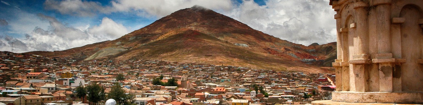
The Spanish continued to extract raw materials from indigenous labor their American colonies, most notably silver from the great mine at Potosi, in modern Bolivia. Silver mines were opened here in 1545 and soon accounted for fully half of the silver produced in the world on an annual basis. On its own, the silver mined at Potosi was of little use to Spanish. The rich don’t love money, but what it can buy for them. In this case, much of the silver mined at Potosi made its way to Ming China – via the Manila Galleon.
Cerro Rico in Potosi, Bolivia. This mountain produced an estimated 60% of all silver mined in the world during the second half of the 16th century.
The Manila Galleon
The death of Ferdinand Magellan while engaged in combat with the warriors of Lapu-Lapu became a potent symbol for later Filipino nationalists chaffing under the rule of the Spanish. (From a diorama in the Ayala Museum, Makati, Philippines, 2018.)
What challenges and what discoveries on behalf of the Spanish led to the opening of the Manila Galleon route?
Did the wealth generated by this trade route benefit all parties equally? Why or why not? Consider the Spanish, the Chinese, and Filipinos in your answer, describing the role of each.
Consider modern trade in the same way – does it benefit all parties equally?
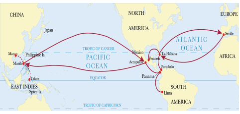
In 1521, just after the conquest of the Aztec in Mexico, and just before the conquest of the Inca in Peru, a Spanish expedition led by Ferdinand Magellan sailed west across the Pacific using the westward trade winds. The expedition arrived in the Philippines, finding there a diverse assortment of tribal groups, Muslim sultanates, and most enticing to the Spanish, a small community of Chinese merchants. Magellan promptly claimed the archipelago for Spain.
Although he died there after involving himself in a local conflict, one of Magellan’s ships made it back to Spain by continuing westward around the tip of Africa. In the decades that followed, other Spanish sailors figured out how to sail east – rising eastward winds at the 38th parallel north, off the coast of Japan – back over the Pacific toward Mexico, a journey that under the best of conditions took four months, but sometimes as long as six. This is an incredibly long time to go without taking on fresh water or food.
The goods arrived in Acapulco and were transported by land across Mexico to the port of Veracruz on the Gulf of Mexico, where they were loaded onto the Spanish treasure fleet bound for Spain. From the early days of exploration, the Spanish knew that the American continent was much narrower across the Panamanian isthmus than across Mexico. They tried to establish a regular land crossing there, but the thick jungle and malaria made it impractical.
This route was a vital alternative to the even riskier trip west across the Indian Ocean, and around the Cape of Good Hope, which was reserved to Portugal according to the Treaty of Tordesillas and fraught with European privateers who might commandeer the Spaniard’s valuable cargo.
View of Manila, c. 1665, complete with galleons in the bay. Notice the fortified, walled Spanish city – Intramuros – in the center, near the Pasig River. On peninsula in the foreground is Cavite, a shipyard and military outpost that continues to serve the Philippine navy today.
As it was, the city of Manila, representing wealth and a formidable European foothold in Asia, became a regional hub of trade and a target for foreign powers. At various times, has Manila come under attack by the Chinese, the Dutch, the English, the Americans, and the Japanese. In 1574, a fleet of Chinese pirates led by Limahong attacked the city and destroyed it before the Spaniards drove them away. The colony was rebuilt by the survivors. These attacks prompted the construction of a walled, stone city – today known as Intramuros – to anchor and secure the eastern end of Spain’s trade route.
Fort Santiago is a citadel first built by Spanish conquistador, Miguel López de Legazpi for the new established city of Manila in the Philippines. The defense fortress is part of the structures of the walled city of Manila referred to as Intramuros. (Manila, Philippines, 2018.)
The first Manila Galleon made the round trip between Acapulco and Manila in 1565, with galleons making the same circuit nearly every year until Mexican Independence in the early 1800s. This trade route, whose main hub was Manila, marked a new chapter in globalization, linking the labor and products of Asia, the Americas, and Europe. While this is a remarkable achievement, it is important to remember that it came about through tremendous hardship, brutality, and exploitation at almost every turn.
A reconstructed galleon, typical of the sort that would have plied the Pacific route between Manila and Acapulco.
Potosi silver – mined, refined, and transported by native slaves under horrendous conditions – was taken by llama and mule train to the Pacific coast. From there, the silver was transported by ship up the coast to the port of Acapulco (in present-day Mexico), and from there on to Manila in the Philippines. This silver was in high demand by the Chinese, who based their monetary system on this precious metal.
Wary of outsiders, the Chinese spurned European attempts to establish trading posts in their home territory. As a result, the Asian end of the galleon trade was supplied by merchants largely from port areas of Fujian in southern China, who traveled with the blessing of the Chinese Emperor to Manila to sell the Spaniards spices, porcelain, ivory, lacquerware, processed silk cloth, and other valuable commodities. These are the same products – so valuable in Europe – that in ancient times fueled the Silk Road; the same ones that nearly a century earlier tempted Columbus and other men hungry for profit.
In Manila, Filipino laborers load an Acapulco-bound galleon under supervision from Spanish managers, who reaped a disproportionate percentage of the profits. (From a diorama in the Ayala Museum, Makati, Philippines, 2018.)
As a result, every available corner of the galleon was dedicated to carrying its profitable cargo – reports even suggest that cisterns meant to carry fresh water were sometimes given over to commercial product – and hygiene was poor. Historian Jan DeVries found that some 2 million men made trading voyages to Asia between 1580 and 1795, but only 920,412 survived: an overall survival rate of just 46%. On the Manila Galleon route, a large number of these men were Filipino, who worked under these harsh conditions for pay that you and I would find appalling – but which represented to them a tremendous windfall, the likes of which were otherwise hard to come by under the poverty of Spanish rule.
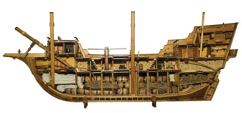
This cross-section of a Spanish galleon hints at the tightly-packed conditions endured by the largely Filipino crews that plied the Manila-Acapulco route.
“In Manila, life was leisurely, even beautiful,” writes David Z. Morris, describing the height of the galleon trade as experienced by the Spanish elite. “The work of administering the galleons took up only two or three months of a year, with the rest of the colonists’ time given purely to lavish parties, carriage rides, and social intrigue. The Spanish were singularly indolent occupiers, developing no aspect of the local economy except the galleon trade.”
The elegant courtyards of Intramuros in Manila bring to mind nothing short of Madrid or Venice – cities of wealth and European culture. Such was the world of the Spanish colonizer as a result of the lucrative galleon trade, but inaccessible to the vast majority of Filipinos. (Manila, Philippines, 2018.)
By contrast, little of this wealth made its way into the hands of Filipinos. The Spanish cultivated a deliberate policy of exclusion toward their colonized subjects – prohibiting their education in the Spanish language as means to hold Filipinos from professional jobs and more cosmopolitan views of the world, encouraging Filipino submission through the careful application and withholding of Catholic teachings, and establishing large Spanish-owned estates in the countryside, reducing the Filipino to little more than an unskilled laborer and a tenant in his own homeland, even as its resources were enriched the Spanish conquerors.
From time to time during more than 300 years of Spanish rule, Filipinos openly rebelled against this injustice. Manila proved to be too lucrative a prize, however, and the Spanish would not let it go so easily, even after Spain’s American colonies achieved independence in the early 1800s. During these centuries, tens of thousands of Filipinos went abroad – settling at the other end of the galleon route, in Acapulco, in Mexico City, in California, seeking greater opportunity outside of the repressive structures that the Spanish had erected to maintain their domination over Manila.
The San Diego
Why is the discovery and recovery of the San Diego valuable to historians?
Formerly known as San Antonio, the San Diego was a trading ship built in Cebu by Filipino workers under the supervision of European boat-builders. It was docked at the port of Cavite to undergo reconditioning and repair, but at the end of October 1600, under threat of an impending Dutch attack on Manila, it was hastily converted into a warship and renamed.
An Illustration of the sinking of the Spanish flagship San Diego after a battle with the Dutch ship Eendracht in Manila Bay in 1600.
On December 14, 1600, the fully laden San Diego was engaged by the Dutch warship Mauritius under the command of Admiral Olivier van Noort a short distance away from Fortune Island, Nasugbu, Philippines. Since San Diego couldn’t handle the extra weight of her cannons, which led to a permanent list and put the cannon portholes below sea level, she was sunk without firing a single shot in response. The Dutch were later reported firing upon and hurling lances at the survivors attempting to climb aboard the Mauritius.
Nearly 400 years later, in 1992, the wreck was discovered by an underwater archaeologist. A total of 34,407 artifacts were recovered from the shipwreck, including more than five hundred blue-and-white Chinese ceramics in the form of plates, dishes, bottles, kendis, and boxes which may be ascribed to the Wan Li Period of the Ming Dynasty; more than seven hundred and fifty Chinese, Thai, Burmese, and Spanish or Mexican stoneware jars; over seventy Philippine-made earthenware potteries influenced by European stylistic forms and types; parts of Japanese samurai swords; fourteen bronze cannons of different types and sizes; parts of European muskets; stone and lead cannonballs; metal navigational instruments and implements; silver coins from the mint at Potosi; two iron anchors; animal bones and teeth (pig and chicken); and seed and shell remains (prunes, chestnuts, and coconut), all of which shed invaluable light on the physical reality of a Manila Galleon.
Recovered from the San Diego was this part of a larger, mass produced set of Chinese porcelain with a deer motif – each hand painted, varying organically, but following the same design. (Manila, Philippines, 2018.)
Another fine example of Chinese porcelain recovered from the San Diego. (Manila, Philippines, 2018.)
This Mexican made vessel is decorated with Mediterranean influenced designs. It was aboard the San Diego when it sunk. (Manila, Philippines, 2018.)
Also aboard the San Diego were these silver coins were mined and minted in Potosi, in modern day Bolivia. (Manila, Philippines, 2018.)
Activities
Design a chart that lists the items in the room around you by their locations of manufacture. Check labels on the items themselves or, when all else fails, ask Google.
Speculate/Research: Choose one of the items that you use every day. Who physically made this item – were they rich or poor, young or old, male or female? Under what conditions do they live and work? Was this item cheap or expensive – why? Who got most of the money that you or your parents paid – the worker or the corporation whose logo appears on the item? Consider yourself, the worker, and the corporation – who are the economic winners and losers in this system? How would your life and the lives of Filipino workers be different if this trade connection did not exist?
Research: What are the primary exports of your country to the Philippines and the rest of the world? What are the Philippines’s primary exports to your country? What is the estimated value of trade in both directions? What kind of modern cultural exchange might accompany this economic exchange?
Use www.marinetraffic.com/ to examine cargo shipping around the globe. What patterns do you notice? Where are the ships most densely clustered? Find a large port near your hometown – where are these ships coming from and going to? Can you determine roughly how long it takes for a ship to travel between the Philippines and the US? Choose several ships and check back in on them over the coming days or weeks – do you notice a route or a pattern for this specific ship, how long it takes to complete this pattern, and so on?
Compare and contrast trade along the Manila Galleon route with modern trade networks. How have changes in technology changed both how goods are traded – and what is traded? Does more or less international trade happen now? Does more or less cultural exchange happen now? Is trade a force for good or ill in the world?
For Discussion: What kind of resources are involved in the manufacture and transportation of new goods? Are there more responsible ways to consume? Ways to avoid consumption all together?
The bangka outrigger boat is ubiquitous in the modern Philippines, used for purposes as varied as trade, fishing, and ferrying. (Taal Lake, Philippines, 2018.)
THIS LESSON WAS INDEPENDENTLY FINANCED BY OPENENDEDSOCIALSTUDIES.ORG.
If you value the free resources we offer, please consider making a modest contribution to keep this site going and growing.
How do goods, wealth, technology, and culture spread? What is gained or lost in the exchange? Does trade benefit all sides equally? Who sets the terms of international trade?
China’s ancient capital of Xian became a cosmopolitan melting pot because its position as a crossroad of the Silk Road trading network, a home to Buddhists and Muslims, where almost anything that was for sale in the ancient world could be bought or sold. (Xian, China, 2015.)


 Moroccans, like many Muslims, look for a leader who has a quality they call barakah – blessed by God. This quality can be demonstrated in many ways – the leader brings prosperity to the country, he leads the army to great victories, a drought ends on his watch. It must have seemed miraculous to these Berbers, living at an unremarkable juncture on the Saharan trade routes that a descendant of the Prophet had come to live among them, and before long he was their leader, further demonstrating his barakah by conquering many neighboring Berber tribes and founding the Idrisid Dynasty, the first great Moroccan-based empire, with Fes as its capital.


You must be logged in to post a comment.